This copy is copyright protected.
Copyright © 2024 Geographicus Rare Antique Maps
1882 Dutton Map of the Grand Canyon, Arizona (4 sheets)
GrandCanyon-dutton-1882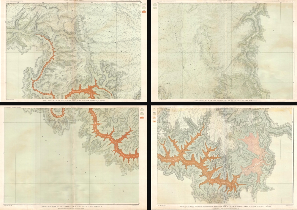

. . . exalt(ing) the mind sufficiently to comprehend the sublimity of the subjects. Their sublimity has in fact been hitherto underrated. Great as is the fame of the Grand Cañon of the Colorado, the half remains to be toldThis map was engraved by Julius Bien and published in Washington D.C. in 1882. The separate panels here can be joined to form a single enormous map.
Clarence Edward Dutton (May 15, 1841 – January 4, 1912) was an American geologist and Army officer. Dutton was born in Wallingford, Connecticut on May 15, 1841. He graduated from Yale College in 1860 and took postgraduate courses there until the outbreak of the American Civil War. In 1862, he enlisted in the 21st Connecticut Volunteer Infantry with which he saw action in Fredericksburg, Suffolk, Nashville and Petersburg. In 1876, when the United States Geological Survey (U.S.G.S.) was created, Dutton began working in the Colorado Plateau where, through his close friendship with John Wesley Powell, G. D. Gilbert, and William Henry Holmes, produced the first detailed atlas of the Grand Canyon. He retired from the Geological Survey in 1891 and took a position as commander of the San Antonio Arsenal, Texas. He retired officially from the army in 1901, but continued to study Geology from his home in Englewood, New Jersey. Dutton in addition to being one of the founders of the U.S.G.S. is also a founding member of the National Geographic Society. More by this mapmaker...
Julius (Julien) Bien (September 27, 1826 - December 21, 1909) was a German-Jewish lithographer and engraver based in New York City. Bien was born in Naumburg, Germany. He was educated at the Academy of Fine Arts, Cassell and at Städel's Institute, Frankfurt-am-Main. Following the suppression of the anti-autocratic German Revolutions of 1848, Bien, who participated in the pan-German movement, found himself out of favor in his home country and joined the mass German immigration to the United States. Bien can be found in New York as early as 1849. He established the New York Lithographing, Engraving & Printing Company in New York that focused on the emergent chromo-lithograph process - a method of printing color using lithographic plates. His work drew the attention of the U.S. Government Printing Office which contracted him to produce countless government maps and surveys, including the Pacific Railroad Surveys, the census, numerous coast surveys, and various maps relating to the American Civil War. Bien also issued several atlases both privately and in conjunction with a relation, Joseph Bien. At the height of his career Bien was elected president of the American Lithographers Association. After his death in 1909, Bien's firm was taken over by his son who promptly ran it into insolvency. The firm was sold to Sheldon Franklin, who, as part of the deal, retained the right to publish under the Julius Bien imprint. In addition to his work as a printer, Bien was active in the New York German Jewish community. He was director of the New York Hebrew Technical Institute, the New York Hebrew Orphan Asylum, and president of the B'nai B'rith Order. Learn More...
The United States Geological Survey (1878 - Present), aka the U.S.G.S., is a scientific agency of the United States government, which was founded in 1879. USGS scientists study the landscape of the United States, its natural resources, and the natural hazards that threaten it. The organization has four major science disciplines: biology, geography, geology, and hydrology. It is a bureau of the United States Department of the Interior and is the department's only scientific agency. Learn More...
Copyright © 2024 Geographicus Rare Antique Maps | Geographicus Rare Antique Maps
This copy is copyright protected.
Copyright © 2024 Geographicus Rare Antique Maps