This item has been sold, but you can get on the Waitlist to be notified if another example becomes available, or purchase a digital scan.
1839 Bradshaw Railroad Map of Great Britain
GreatBritain-bradshaw-1839$675.00

Title
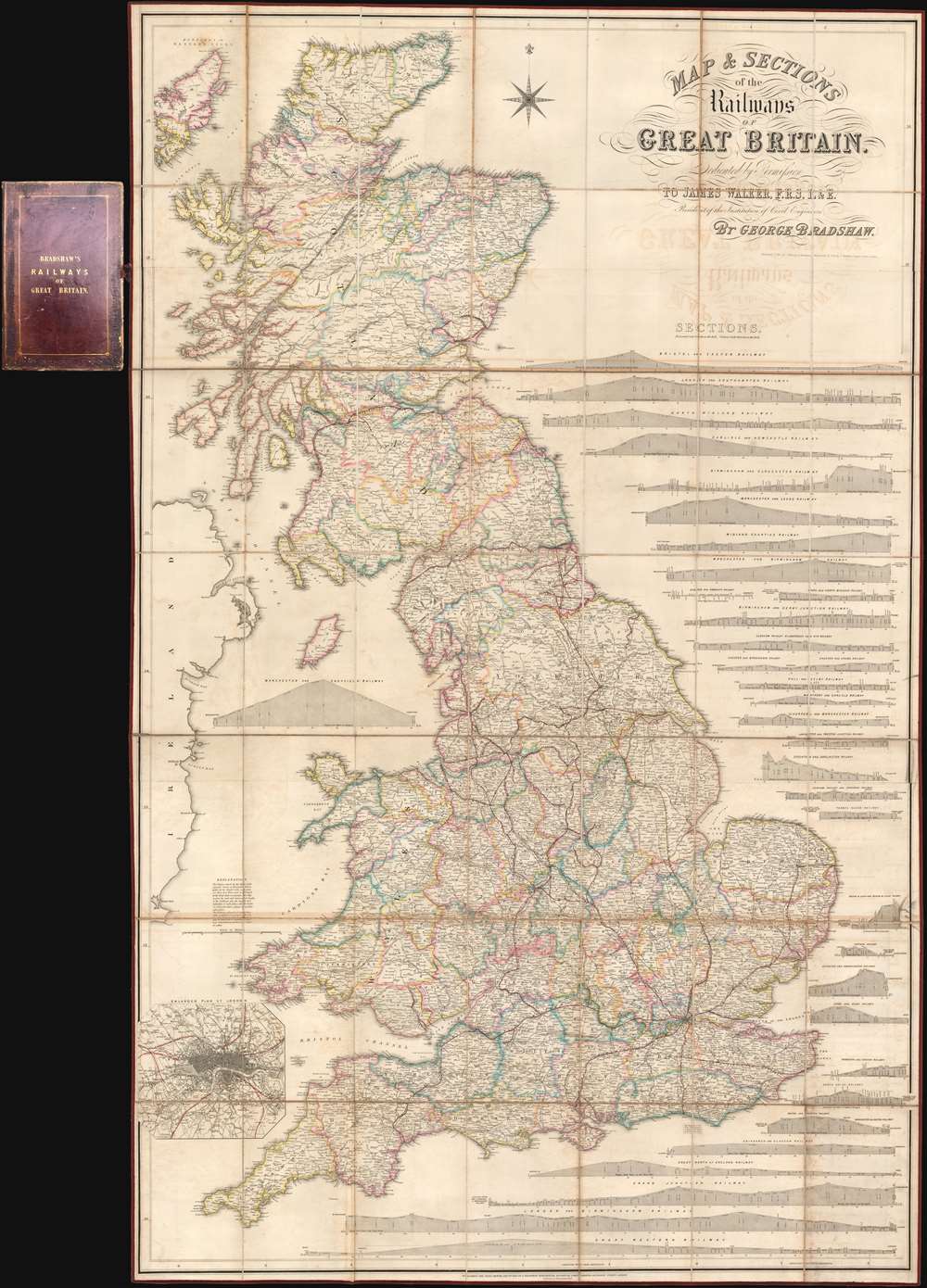
Map and Sections of the Railways of Great Britain.
1839 (dated) 65 x 40.5 in (165.1 x 102.87 cm) 1 : 633600
1839 (dated) 65 x 40.5 in (165.1 x 102.87 cm) 1 : 633600
Description
Here in its rare first edition, this 1839 map of Great Britain by George Bradshaw is considered to be the first comprehensive railroad map. The map covers all of Great Britain as well as parts of the Hebrides and Ireland. Complete railroad lines are identified in strong red, while lines under construction or proposed, such as the 'Northern and Eastern Railway' and the 'Manchester and Birmingham Extension', appear in yellow. It is of note that, while this my no means the first map to show a railroad, it is, in the words of map historian Rodney Shirley,
This map is rare in its first edition. We have identified examples at the University of British Columbia, The National Library of Scotland, and the Huntington Library. Other holdings are typically later editions.
undoubtedly the first large scale map to treat railways as the primary subject in terms of content and presentation.… and indeed the map is magnificent in size and presentation, comprehensive in scope, and extensive it is meticulous attention to detail. In addition to the map proper, there are 32 profile sections illustrating elevation for each major railway. An inset map of London and vicinity appears in the lower left quadrant.
The Development of British Railroads
Great Britain was fast to adapt to railroad technology, constructing one of the world's first large scale railroad networks. Nonetheless, despite rapid growth, a proper comprehensive railroad map was not available until Bradshaw compiled this work. 1839 was an important year for British Railroads. In that year the important 'London and Birmingham' line was completed and, one year later, the 'Great Western' began operations. In 1830, when Bradshaw began publishing railroad guides in Manchester, the network of passenger railways could claim only about 100 miles of track (some under construction), by the end of the decade, when this map was published, there were more than 2000 miles of working track.Publication History and Census
The present example is the first edition, published in January 14,1839, or as Bradshaw, whose Quaker religious values did not allow him to use pagan-inspired month names, called it, the '1st Mo. 14.' The map was subsequently updated and revised near annually until at least 1847. The map is dedicated to the Scottish civil engineer James Walker (1781 - 1862), then president of the Institution of Civil Engineers. This was Bradshaw's greatest accomplishment and accordingly appears prominently behind him in his portrait at the National Portrait Gallery in London. The engraving is generally attributed to John Dower, although we have not been able to identify Dower's imprint anywhere on the work. It is accompanied by Bradshaw's 'Address to the Public' and a 27 page letterpress Tables of the Gradients.This map is rare in its first edition. We have identified examples at the University of British Columbia, The National Library of Scotland, and the Huntington Library. Other holdings are typically later editions.
Cartographer
George Bradshaw (July 29, 1801 - September 6, 1853) was a British map publisher active in the middle part of the 19th century. Bradshaw was born in Windsor Bridge, Pendleton, Lancashire, England, the only son of Thomas Bradshaw and Mar Rogers. From 1815, when he was 14, he apprenticed in Manchester under the engraver J. Beale. After his apprenticeship, in 1820, he moved briefly to Belfast, where he worked as a printer and engraver. He returned to Manchester in 1821, and there concentrated on map engraving. Around 1839, he began publishing railroad timetables, maps, and guides, which he updated monthly. He had, by this time, taken on his own apprentice, William Thomas Blacklock, who joined the Bradshaw firm as a partner in 1842. The firm was thus renamed 'Bradshaw and Blacklock.' Bradshaw's railroad guides were extremely successful, earning him both fame and wealth. On a trip to Norway in 1853, Bradshaw contracted cholera and died in Christiania, where he is buried. The firm continued to publish under the 'Bradshaw and Blacklock' imprint for many years after his death. In addition to his publishing work, when he was 20 or so, Bradford became a Quaker, joining the Society of Friends. More by this mapmaker...
Condition
Very good. Some offsetting. Folds into handsome leather binder. Original linen backing and edging.
References
OCLC 82189635. Wardington Sale; Sotheby’s, October 18, 2005; lot 69.