This item has been sold, but you can get on the Waitlist to be notified if another example becomes available, or purchase a digital scan.
1710 Moll Map of England and Wales
GreatBritainEngland-moll-1710$300.00

Title
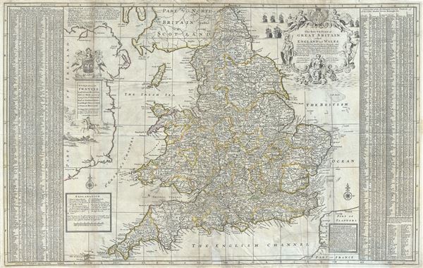
The Southern Part of Great Britain called England and Wales.
1710 (dated) 24.5 x 38 in (62.23 x 96.52 cm) 1 : 1000000
1710 (dated) 24.5 x 38 in (62.23 x 96.52 cm) 1 : 1000000
Description
This is a fascinating 1710 Herman Moll map of South Britain, or England and Wales. It depicts the entirety of England and Wales, including the Isle of Man. The map is extremely detailed, noting cities, roads, towns, bishoprics, archbishoprics, distances between towns, rivers, and a host of additional topographical features. This map also offers splendid detail throughout with respect to undersea shoals and reefs in the surrounding waters. An exhaustive alphabetical list of the towns of England and Wales, a list of parliamentary constituencies, is included along the left and right borders of the map.
The Wall of Hadrian or Picts Wall, fortifications built by the Roman Empire to defend against the unruly tribes of the north, are identified.
The top right quadrant of the map features a large ornamental title cartouche which includes the coat of arms and a fleet of ships. Another cartouche near the top left features a dedication to 'Francis lord Viscount Rialton' with the Godolphin family coat of arms and a country scene depicting horse riders. This map was created by Herman Moll in 1710.
Cartographer
Herman Moll (1654 - 1732) was an important 18th century map publisher and engraver based in London and Holland. Moll's origins are disputed with some suggesting he was born in the Netherlands and others Germany - the Moll name was common in both countries during this period. Most likely Moll was a German from Bremen, as his will, friends, and contemporaries suggest. What is known for certain is that he moved to London in 1678, possibly fleeing the Scanian War, where he worked as an engraver for Moses Pitt and other London map publishers. Around the turn of the century, Moll set up his own shop where he produced a large corpus of work known for its high quality and decorative flair. As a new émigré to England, Moll made himself more English than the English, and through his cartography proved a fierce advocate for his adopted nation. Most of Moll's early maps were issued as loose sheets that would be bound to order, however, he did publish several important atlases late in his career. Moll is said to have made the bold claim that without a doubt "California is an Island" and that he "had in [his] office mariners who have sailed round it." While California may not be an island (yet), it is true that Moll had talent for attracting interesting friends and acquaintances. He frequented London's first stock exchange, Jonathan's Coffeehouse at Number 20 Exchange Alley, Cornhill. At the time Jonathan's was known as "a place of very considerable concourse for Merchants, sea faring Men and other traders" (Erleigh, The Viscount, The South Sea Bubble, Manchester: Peter Davies, Ltd., 1933, 21). Eventually this activity attracted the interest of stock brokers, who inspired by sailor's tales, sponsored the ill-fated South Sea Company, the world's first stock bubble. Moll's close circle, mostly from the Coffee House, included scientist Robert Hooke, the writers Daniel Defoe (Robinson Crusoe) and Jonathan Swift (Gulliver's Travels), the pirates William Dampier, William Hacke and Woodes Rogers, and the archeologist William Stukeley. Herman Moll's work was highly regarded for its decorative beauty and was pirated, most notably by the Irish publisher George Grierson, both in his lifetime and after his 1732 death at St. Clement Danes, London. More by this mapmaker...
Condition
Very good. Overall toning and creasing. Verso repair along centerfold damage. Minor spotting. Minor wear along original fold lines.