1815 Direccion Hidrografia Chart of the Greater Antilles and Environs
GreaterAntilles-direccionhidrografia-1815$1,600.00


Title
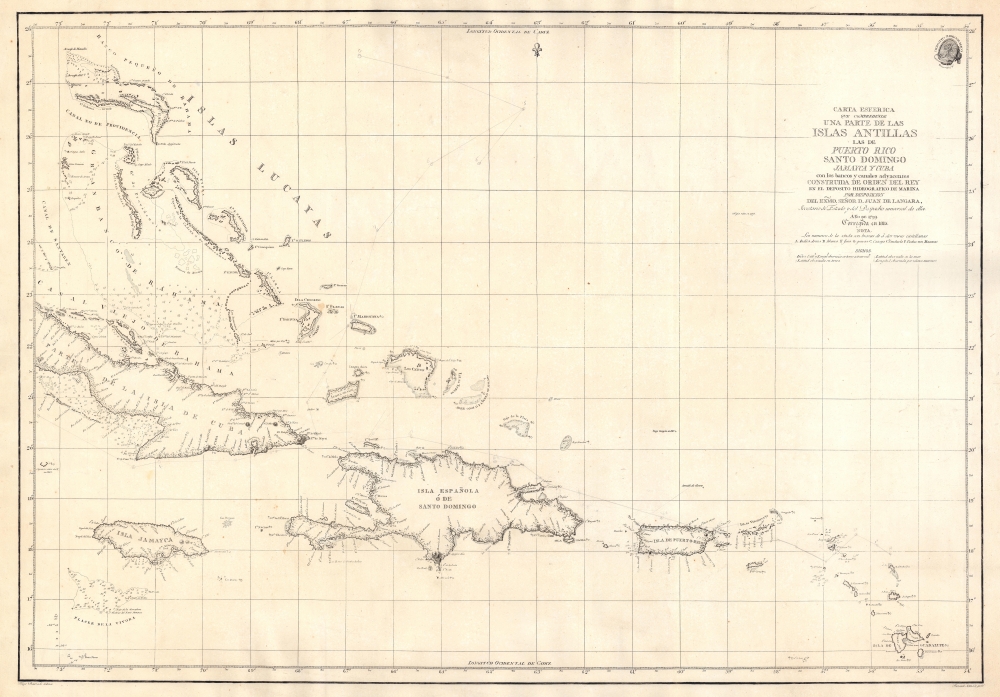
Carta Esferica que Comprehende una Parte de las Islas Antillas, las de Puerto Rico, Santo Domingo, Jamayca y Cuba con los Bancos y Canales Adyacentes.
1815 (dated) 23.5 x 33.5 in (59.69 x 85.09 cm) 1 : 2300000
1815 (dated) 23.5 x 33.5 in (59.69 x 85.09 cm) 1 : 2300000
Description
An impressive large-format nautical chart, produced in 1815 by the Spanish Dirección Hidrografía, covering the waters off the Greater Antilles and surrounding islands, taking in Cuba, the Bahamas, Hispaniola, Jamaica, Puerto Rico, the Virgin Islands, and Guadeloupe.
A Closer Look
Ranging from Grand Bahama and Great Abaco to Guadeloupe, with dozens of islands and islets in between, this chart provides fantastic detail on coastal terrain and settlements, hazards, shoals, soundings, anchorages, and other important navigational features. Abbreviations and signs are explained below the title, with the latter indicating where and how longitude measurements were taken at various points (longitude is measured from the Real Instituto y Observatorio de la Armada in Cadiz). Hand-drawn annotations appear to track the course of one or perhaps two vessels through the region, suggesting that the map was used on a ship.Publication History and Census
This chart was drawn by Felipe Bauza and engraved by Fernando Selma for the Dirección Hidrografía. It was first issued in 1799, and was subsequently corrected to 1815 and 1825. Despite the note 'bajo guigou en 1817' at center towards bottom-right, which appears to be predictive rather than retrospective, the present chart algins with other known examples dated to 1815 and differs notably from the 1825. The present edition is only known to be held by the University of Florida, the British Library, the Museu Marítim de Barcelona, and the Bayerische Staatsbibliothek.CartographerS
The Direccion Hidrografía (1787 - 1927), also known as the Deposito Hydrografico and the Direction de Hidrografía, was the Spanish equivalent of the British Admiralty or the U.S. Coast Survey. This organization, founded in 1787, was commissioned to collect and produce accurate nautical charts of all waters frequented by Spanish vessels. In essence, it replaced the Casa de la Contratación de las Indias (House of Trade of the Indies), which closed its doors in 1790. Like most such organizations, the Direccion Hidrografía marked a new age in cartography. Rather than simply collect charts created by navigators, explorers, and merchants, the Direccion Hidrografía worked closely with naval and military personnel to mount cartographic and hydrographic expeditions in pursuit of the most accurate hydrographical, astronomical, and geodetic measurements. The Direccion Hidrografía created a massive library of nautical charts that, though not nearly as common as similar nautical charts by the U.S. Coast Survey and British Admiralty, are highly desirable for the beauty of their manufacture as well as their accuracy and detail. The office was originally located on Calle Ballesta, but relocated to 36 Alcala, both in Madrid. After 1908 the Dirección was subsumed into other governmental agencies. In 1927 the Direccion was absorbed into the Institute and Observatory of San Fernando, located in Cadiz. The library of original maps, charts, and journals was transferred to the Naval Museum of Madrid - where it resides to this day. More by this mapmaker...
Felipe Bauzá y Cañas (February 17, 1764 - March 3, 1834) was a Spanish cartographer, navigator, and naval officer active in the late 18th and early 19th centuries. Bauzá was born on the Balearic Islands in the Mallorcan city of Palma. He attended the Spanish maritime college in Cartagena, Spain. He saw action during the Siege of Gibraltar (1779 - 1782), the capture of Port Mahón, and a campaign against the Moors (1783 - 1784). Exhibiting a proficiency in mathematics and draftsmanship, he subsequently trained as a hydrographer and cartographer under Vicente Tofiño (1732 – 1795), the premier Spanish nautical chartmaker of the day. Bauzá was the head cartographer on the Malaspina Expedition (1789 - 1794) to the Americas, Oceania, and Australasia. From 1797, he worked with the Depósito Hidrográfico / Dirección Hidrografica in Madrid, becoming head of said organization in 1815. Renowned as a cartographer, he was honored with the Russian Cross of St. Vladimir in 1816 and was elected a Foreign Member of the Royal Society of London in 1819. From about 1800, he began assembling a personal collection of maps and charts intended to form the backdrop of a series of definitive maps of Latin America. Political fate intervened with his plan. Bauzá was a supporter and leader of the of Rafael de Riego Revolution in 1920, and served the Cortes Generales during the Trienio Liberal ('Three Liberal Years', 1820 - 1823), as the deputy for Mallorca. After the fall of that regime, in 1823, he was sentenced to death by King Ferdinand VII. Bauzá fled to England in that year, taking with him his nautical charts and other geographical source materials. Bauzá and his family struggled in London, attempting to support themselves by publishing his cartography and selling parts of his collection to the British Admiralty's Hydrographic Office. His death sentence was finally commuted in 1833, but before he could return to Spain, he died of a brain hemorrhage. He family was left in destitution and his widow Teresa Rivera y Bauzá, made ends meet by selling his map collections. Some went to foreign governments (Venezuela) but most are not part of the Bauzá collection in the British Library. Learn More...
Ferdinand Selma (1752 - January 8, 1810) was a Spanish line engraver active in Madrid with the Direccion Hidrografía in the late 18th and early 19th centuries. Selma was born in Valencia and died in Madrid. His is best known for his engravings for his 1788 Illustrations de Relacion del ultimo viage al estracho de Magallanes. Learn More...
Condition
Very good. Uneven toning and light foxing.
References
OCLC 1099272692, 557910554, 165257313. Museu Marítim de Barcelona Núm Registre:2222C.