
1856 Kolmann Set of Greek Educational Maps

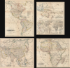
ΧAΡΤΗΣ ΤΗΣ ΑΜΕΡΙΚHΣ / ΧAΡΤΗΣ ΤΗΣ ΑΥΣΤΡΑΛIΑΣ / ΧΆΡΤΗΣ ΤΗΣ ΑΣIΑΣ / ΧAΡΤΗΣ ΤΗΣ ΑΦΡΙΚHΣ.
Geography for the Nation, in Greek!
- Digital Map Information
- Suitable for large format printing
- File Size: 91.34 MB
- File Type: ZIP / TIFF
- ICC color profile embedded
- Delivered instantly via download link
Geography for the Nation, in Greek!
This is an extremely rare c. 1856 set of four Greek-language educational maps published by the Athenian printer Karl Joseph Kolmann. The maps represent an early attempt by the newly independent Greece to reform and nationalize its educational system.A Closer Look
The set consists of four maps, with the first covering the Americas. Color outlines are used to distinguish territories of different empires and countries, such as the red used for Britain's American colonies. Though the border between the United States and Canada (British North America) is somewhat squiggly, the borders roughly approximate those of the time. Cities, forts, and frontier settlements are labelled throughout, with an index at right listing individual American states and territories. California appears as 'New California' (ΝΕΑ ΚΑΛΙΦΟΡΝΙΑ), while the Pacific Northwest includes Oregon and 'New Albion' (ΝΕΑ ΑΛΒΙΩΝ). It is likely that Kolmann was working off an old map (maybe even from the 1820s), as the large Indian Territory (later Missouri Territory) in the Great Plains translates the names of the loosely divided formerly-French districts of that era: Ozark, Osage, and Mandan (ΟΖΑΡΚΗ, ΟΣΑΓΗ, ΜΑΝΔΑΝ). Handwritten annotations throughout, including doodles, suggest that the map saw actual use by a student.The following sheet includes a map of Australia and Insular Southeast Asia. Though titled 'Map of Australia,' the continent itself is labeled 'New Holland' (ΝΕΑ ΟΛΛΑΝΔΙΑ). Here, too, hand-color outlines are used to distinguish the territories. The bottom half of the sheet contains two polar projections, of the Northern and Southern Hemisphere, respectively, along with a smaller hemisphere explaining latitude-longitude and the tropics. It also includes a 'Universal map of civilization' (ΧΑΡΤΗΣ ΟΙΚΟΥΜΕΝΙΚΟΣ ΤΟΥ ΠΟΛΙΤΙΣΜΟΥ) on a Mercator projection with information about different countries' level of 'civilization,' land area, population, religion, and other details. The Asia and Africa maps follow the same pattern of hand-color outlines for different empires and kingdoms, but reflect the still-imperfect geographical knowledge of the time, especially with regard to Africa. These two maps also contain some annotations and ink smudges indicating use by a Greek student long ago.
Didactic Maps in the National Language
In 1856, Greece remained a young and fragile kingdom still consolidating its independence, which had only been officially recognized some 25 years earlier. After the Greek statesman and Governor (effectively a Prime Minister) Ioannis Kapodistrias was assassinated in 1831, Britain, France, and Russia determined, without Greek input, that the country needed a monarchy and set up the young Otto I of Bavaria (r. 1832 - 1862) as King of Greece. His reign was marked by efforts to modernize the country's institutions, economy, army, and educational system. These maps are related to the aspiration of Greek publishers, including Kolmann, who partly specialized in educational material, to provide up-to-date geographical information about the world to Greek students in the national language. We have been unable to concretely identify source maps for the present maps, but they most likely would have been based on leading British or perhaps French cartographers of the era.Publication History and Census
These maps were published by Karl Joseph Kolmann (Καρλ Γιόζεφ Κόλμαν or Κόλμανν) in or around 1856 in Athens. Publication information differs somewhat from map to map: the Americas map names Karl Joseph Kolmann and is dated 1855 (noting that the stone on which it was lithographed came in 1852 from a mountain near Missolonghi, site of a critical battle in the Greek War of Independence); the Australia map mentions Kolmann but also says that is was printed by Ch. Christodoulou (Χ. Χριστοδούλου); the Asia map is recorded as having been engraved by K. and G. Kolman (Κ. και Γ. Κόλμαν) suggesting a brother or son of Karl; and the Africa map lacks any publication information but is stylistically similar to the others. The maps' subtitles read: 'For the atlas intended for the use of primary and Greek [i.e., secondary] schools,' suggesting that these maps were all originally part of a school atlas, likely with a map of Europe and Greece itself. In any event, we have been unable to locate any other examples of the individual maps or of such an atlas in institutional collections, while the maps have been on the market only once (at a Greek auction house) in recent years. It is possible that these maps were influential on the later works of Herakles Lazaridou (see our Americas-lazaridou-1866).Cartographer
Karl Joseph Kolmann (Καρλ Γιόζεφ Κόλμαν; 1812-1870), also as Κόλμανν, was a publisher of maps, educational materials, and other works based in Athens. Although he published in Greek and may have been born there, his name suggests that his family was of German extraction. Kolmann's early life and training are a mystery, but he was publishing maps on his own or with a G. Kolmann (Γ. Κόλμαν) by the mid-1850s, and works continued to be publish under Kolmann's name even after his death, into the mid-1880s. At some point in this period, the Kolmann lithography studio was sold to Vasileios Papachrysanthou (Βασίλειος Παπαχρυσάνθου), who then founded a new firm under his own name in 1888, which also published maps. Vasileios' son Phoebus Papachrysanthou (Φοίβος Παπαχρυσάνθου, 1900-1986) continued the business until about the mid-1950s. Soon afterwards, another publishing house employing the same surname (Κ. and Σία Παπαχρυσάνθου) produced colorful chromolithographic film posters, but it is unclear if they are related to the earlier Papachrysanthou family. Further Details...
Condition
Good. Soiling. Toning. Laid down on original linen. Some wear on old fold lines.