This item has been sold, but you can get on the Waitlist to be notified if another example becomes available, or purchase a digital scan.
1885 Atkinson Map of Western China
GrossTibet-atkinson-1885$175.00

Title
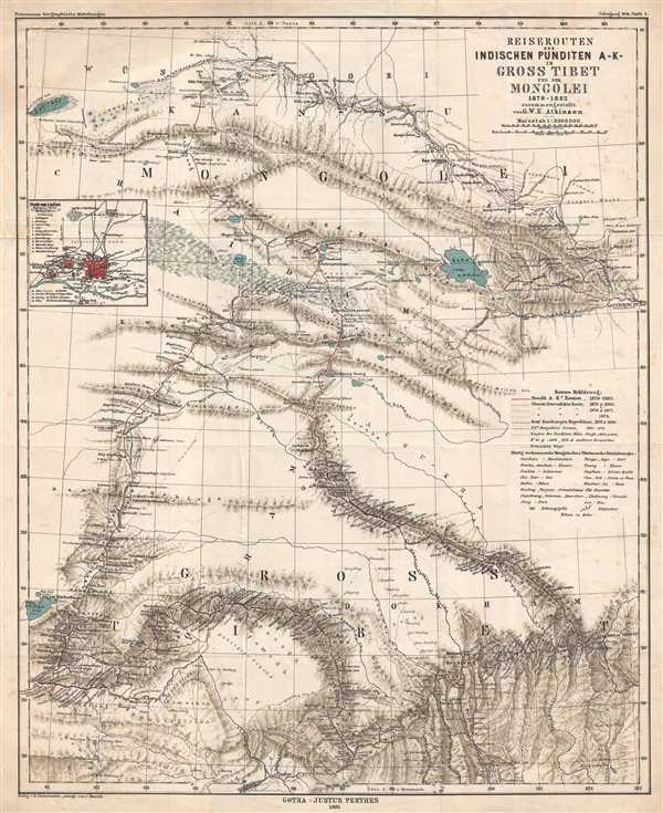
Reiserouten des Indischen Punditen A - K - in Gross Tibet und der Mongolei 1879-1882.
1885 (dated) 20.5 x 17 in (52.07 x 43.18 cm) 1 : 3000000
1885 (dated) 20.5 x 17 in (52.07 x 43.18 cm) 1 : 3000000
Description
This is an 1885 map of expeditions in western China compiled by G.W.E. Atkinson. The map depicts from Mongolia through Qinghai Province to Tibet. The map illustrates several different routes takes by different explorers, including the route of three different expeditions by Russian explorer Nikolay Mikhaylovich Przhevalsky, in 1873, 1876 and 1877, and 1879 and 1880. Several cities and towns are labeled, including Lhasa, which is situated in the lower left quadrant of the map near the border. An inset map of the city of Lhasa is included along the left border and 19 locations are identified within the city. Lhasa was Przhevalsky's goal, but he never actually saw the Tibetan capital. Nonetheless, his expeditions mapped previously little known territory and brought back a wealth of scientific information.
This map was published by Petermanns Geographische Mitteilungen in Gotha in 1885.
This map was published by Petermanns Geographische Mitteilungen in Gotha in 1885.
Cartographer
Bruno Hassenstein (November 23, 1839 - August 27, 1902) was a German cartographer and was born in Ruhla, Thuringia. In 1854, Hassenstein began studying cartography and working under August Petermann in Gotha, founder of Petermanns Geographische Mitteilungen. Over the ensuing years, Hassenstein drew numerous maps for Petermanns Geographische Mitteilungen before relocating to Berlin in 1866 to work for another cartographer, including Karl Klaus von der Decken. He returned to Gotha two years later and works on maps for Henrich Theodor Menke's edition of Spurner's atlas of medieval history. He became editor of the cartography section of the Mittellungen in 1878 and worked on the Atlas von Japan, which was published in 1885. The University of Göttingen awarded him an honorary doctorate in 1878. More by this mapmaker...
Condition
Very good. Foxing throughout. Blank on verso.