This item has been sold, but you can get on the Waitlist to be notified if another example becomes available, or purchase a digital scan.
1815 Thomson Map of Guadaloupe, Antigua, Marie Galante ( West Indies )
Guadeloupe-thomson-1815$100.00

Title
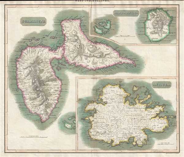
West India Islands. Guadaloupe. Antigua. Mariegalante etc.
1815 (undated) 20.25 x 23.5 in (51.435 x 59.69 cm) 1 : 120000
1815 (undated) 20.25 x 23.5 in (51.435 x 59.69 cm) 1 : 120000
Description
This is an 1815 John Thomson map of Guadeloupe, Antigua, and Marie-Galante in the West Indies. Each island is depicted as an inset, with each inset focusing on one island. All three islands are illustrated in detail, with numerous coastal locations, towns, villages, and other physical features labeled on each of them. The topography of the islands is also depicted, with Sainte Anne and La Soufriere labeled on Guadeloupe.
This map was engraved by Kirkwood and Son of Endiburgh and published by John Thomson in the 1815 edition of Thomson's A New General Atlas.
This map was engraved by Kirkwood and Son of Endiburgh and published by John Thomson in the 1815 edition of Thomson's A New General Atlas.
CartographerS
John Thomson (1777 - c. 1841) was a Scottish cartographer, publisher, and bookbinder active in Edinburgh during the early part of the 19th century. Thomson apprenticed under Edinburgh bookbinder Robert Alison. After his apprenticeship, he briefly went into business with Abraham Thomson. Later, the two parted ways, John Thomson segueing into maps and Abraham Thomson taking over the bookbinding portion of the business. Thomson is generally one of the leading publishers in the Edinburgh school of cartography, which flourished from roughly 1800 to 1830. Thomson and his contemporaries (Pinkerton and Cary) redefined European cartography by abandoning typical 18th-century decorative elements such as elaborate title cartouches and fantastic beasts in favor of detail and accuracy. Thomson's principle works include Thomson's New General Atlas, published from 1814 to 1821, the New Classical and Historical Atlas of 1829, and his 1830 Atlas of Scotland. The Atlas of Scotland, a work of groundbreaking detail and dedication, would eventually bankrupt the Thomson firm in 1830, at which time their plates were sequestered by the court. The firm partially recovered in the subsequent year, allowing Thomson to reclaim his printing plates in 1831, but filed again for bankruptcy in 1835, at which time most of his printing plates were sold to A. K. Johnston and Company. There is some suggestion that he continued to work as a bookbinder until 1841. Today, Thomson maps are becoming increasingly rare as they are highly admired for their impressive size, vivid hand coloration, and superb detail. More by this mapmaker...
Robert Kirkwood (December 8, 1774 – November 14, 1818) was a Scottish engraver active in Edinburgh during the late 18th and early 19th century. He is the scion of the important Scottish Kirkwood family, who produced a number of great engravers. His father was James Kirkwood, another well-known Edinburgh engraver, and probably the man who trained him in the engraver's art. Initially he patterned with his father and they published under the imprint of 'Kirkwood and Son,' but after about 1814 to his death, he published under his own name. Around 1803 Kirkwood invented and patented a modification to the standard printing press that increased printing speeds. He died at his home, 3 Arniston Place, in Edinburgh. He was survived by his son, also Robert Kirkwood (1798 – 1843) who continued the family engraving enterprise. Learn More...
Source
Thomson, J. A New General Atlas, (Edinburgh) 1815.
Condition
Very good. Even overall toning. Blank on verso.
References
Catalogue of maps of Hispanic America, v. 1, p. 245. Rumsey 1007.071.