This item has been sold, but you can get on the Waitlist to be notified if another example becomes available, or purchase a digital scan.
1898 La Depeche Map of the Eastern United States and the Caribbean
GuerreHispanoAmericaine-depeche-1898-2$775.00


Title
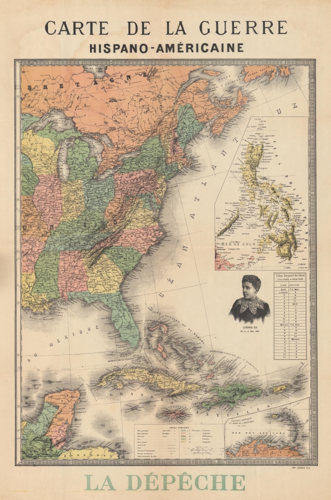
Carte de la Guerre Hispano-Américaine.
1898 (undated) 30 x 19.5 in (76.2 x 49.53 cm) 1 : 7000000
1898 (undated) 30 x 19.5 in (76.2 x 49.53 cm) 1 : 7000000
Description
This is an 1898 anti-American propaganda map of the eastern United States and the Caribbean published during the Spanish-American War (April 21, 1898 - December 10, 1898) by the 'then' radical-socialist French newspaper La Depêche. The map illustrates the eastern United States, the Caribbean, and, in a large inset, the Philippines - thus detailing all major theaters of engagement. In the Atlantic, there is a striking vignette engraving a very worried looking Alphonso XIII, the boy King of Spain. Alphonso XIII was King of Spain from birth and in this illustration is just 12, as the map underscores by printing his birth date. The anti-American message is subtle but clear - look at the big bad USA bullying this poor little boy.
The Spanish-American War
The Spanish-American War was fought between Spain and the United States between April 21, 1898, and August 13, 1898. The war started after the USS Maine suffered a massive explosion and sank in Havana Harbor. Tensions had been rising between the two countries for some time, with the U.S. showing support for Cuban independence while Spain claimed Cuba as a province. After the fighting, the U.S. received the Philippines, Guam, and Puerto Rico as territories and Cuba became a U.S. protectorate.Publication History and Census
This map was created and published by the French newspaper La Depêche. It was engraved and printed by Cassan Fils. We have encountered at least one other state, without La Depêche printed in the lower margin. We are aware of only one other surviving example of the present state which is in private hands.Cartographer
La Dépêche du Midi (October 2, 1870 - Present) is a regional French daily newspaper circulated in southeastern France. The newspaper first appeared under the title La Dépêche and its first issue was published on October 2, 1870. Famous French politicians Jean Jaurès and Georges Clemenceau wrote for La Dépêche early in their careers. La Dépêche soon became associated with the radical-socialist left wing of French politics, and by the beginning of the twentieth century, French Catholic bishops began to see reading the paper as a 'grave sin.' The paper continued publishing throughout the twentieth century. However, since La Dépêche was operated by collaborationists during World War II, it was banned after the Liberation of France. It reemerged with the name La Dépêche du Midi in 1947. Nonetheless, La Dépêche again took firm radical left and anticommunist positions. More by this mapmaker...
Condition
Good. Wear along original fold lines. Small area of loss at one fold intersection. Reinforcement at a few fold intersections. Light dampstaining barely visible on recto. Verso repair to a fold separation in margin.