1807 Vaugondy Map of Poland following the Third Partition
GuerrePologne-vaugondy-1807$750.00

Title
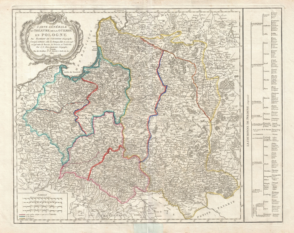
Carte générale du théatre de la guerre en Pologne… Corrigée et Divisée selon les Partages faits en 1772, 1793 et 1795 entre la Russie, la Prusse et l'Autriche.
1807 (dated) 20 x 24.5 in (50.8 x 62.23 cm) 1 : 2490000
1807 (dated) 20 x 24.5 in (50.8 x 62.23 cm) 1 : 2490000
Description
A rare 1807 Robert de Vaugondy/Charles Delamarche map illustrating the partitioning of Poland between 1772 and 1795. The map follows the 1807 Treaty of Tilsit, through which Napoleon reconstituted the Pre-Partition 1772 Polish-Lithuanian Commonwealth.
The map employs color coding to identify territories divided by Austria, Prussia, and Russia. The Poland here illustrated follows the 1795 Third Partition. Russia has annexed the entire western half of the former Polish-Lithuanian Confederation. Austria seized the lands around Lwow and Krakow, and Prussia claimed the territories to the north and west of Warsaw.
A Closer Look
The map extends from Poznan east to Russia and from the Gulf of Livonia south to Moldova and Hungary. The map is attributed to Robert de Vaugondy, who provided the base cartography, but it has been heavily updated by Charles Delamarche, Vaugondy's successor. The map illustrates the phased partition of Poland. In 1807, there was considerable interest in Poland among the French population. Napoleon soundly defeated Russian forces in the June 14, 1807 Battle of Friedland, cementing his control of Central Europe. The subsequent signing of the Treaties of Tilsit by Tsar Alexander I of Russia and Napoleon Bonaparte of France created the Duchy of Warsaw, which partially reconstituted the Pre-Partition 1772 Polish-Lithuanian Commonwealth. Many Poles anticipated that Napoleon would complete the reconstitution by incorporating the Grand Duchy of Lithuania. As such, the history of Poland's partition and the lands potentially to be claimed were a matter of considerable interest among the French populace. Fast-moving political events, nonetheless, soon shifted attention elsewhere, and the interest in this map proved ephemeral, possibly accounting for its extraordinary rarity.The map employs color coding to identify territories divided by Austria, Prussia, and Russia. The Poland here illustrated follows the 1795 Third Partition. Russia has annexed the entire western half of the former Polish-Lithuanian Confederation. Austria seized the lands around Lwow and Krakow, and Prussia claimed the territories to the north and west of Warsaw.
Partitioning of Poland
By the mid-18th century, Poland, due to an inefficient and corrupt internal bureaucracy, had lost much of its autonomy to its aggressive and powerful neighbors, Russia, Austria, and Prussia. The First Partition occurred in 1772, with Prussia occupying Poland's long coveted western territories, Austria seizing Galicia, and Russia taking part in Livonia. In the aftermath of the First Partition, the Second Partition was almost inevitable. Poland allied with Prussia to thwart Russia's ambitions in the east. This, along with several other factors, led to the War in Defense of the Constitution between Poland and Russia. Largely abandoned by their Prussian allies, Poland could not hope to stand against the powerful Russian military. Poland's defeat resulted in the loss of nearly 50% of its remaining territory to Russia and Prussia, who signed an accord in 1793. The Third Partition of Poland in 1795 dissolved what remained of the reduced Polish-Lithuanian Commonwealth, ending Polish all autonomy until Napoleon created the Duchy of Warsaw in 1807, the year this map was issued.Publication History and Census
Originally created by Robert de Vaugondy, this map was issued in 1807 by Charles Delamarche. It does not regularly appear in Delmarche issues of the Atlas Universel, so we may assume it was a separate issue. This map is consequently exceedingly rare. Three examples are cataloged in OCLC and are part of the collections at the University of Wisconsin-Milwaukee, the University of Minnesota Twin Cities, and the Bibliothèque nationale de France.CartographerS
Robert de Vaugondy (fl. c. 1716 - 1786) was French may publishing from run by brothers Gilles (1688 - 1766) and Didier (c. 1723 - 1786) Robert de Vaugondy. They were map publishers, engravers, and cartographers active in Paris during the mid-18th century. The father and son team were the inheritors to the important Nicolas Sanson (1600 - 1667) cartographic firm whose stock supplied much of their initial material. Graduating from Sanson's maps, Gilles, and more particularly Didier, began to produce their own substantial corpus. The Vaugondys were well-respected for the detail and accuracy of their maps, for which they capitalized on the resources of 18th-century Paris to compile the most accurate and fantasy-free maps possible. The Vaugondys compiled each map based on their own geographic knowledge, scholarly research, journals of contemporary explorers and missionaries, and direct astronomical observation. Moreover, unlike many cartographers of this period, they took pains to reference their sources. Nevertheless, even in 18th-century Paris, geographical knowledge was limited - especially regarding those unexplored portions of the world, including the poles, the Pacific Northwest of America, and the interiors of Africa, Australia, and South America. In these areas, the Vaugondys, like their rivals De L'Isle and Buache, must be considered speculative or positivist geographers. Speculative geography was a genre of mapmaking that evolved in Europe, particularly Paris, in the middle to late 18th century. Cartographers in this genre would fill in unknown lands with theories based on their knowledge of cartography, personal geographical theories, and often dubious primary source material gathered by explorers. This approach, which attempted to use the known to validate the unknown, naturally engendered rivalries. Vaugondy's feuds with other cartographers, most specifically Phillipe Buache, resulted in numerous conflicting papers presented before the Academie des Sciences, of which both were members. The era of speculative cartography effectively ended with the late 18th-century explorations of Captain Cook, Jean Francois de Galaup de La Perouse, and George Vancouver. After Didier died, his maps were acquired by Jean-Baptiste Fortin, who in 1787 sold them to Charles-François Delamarche (1740 - 1817). While Delamarche prospered from the Vaugondy maps, he defrauded Vaugondy's window Marie Louise Rosalie Dangy of her rightful inheritance and may even have killed her. More by this mapmaker...
Charles-François Delamarche (August 1740 - October 31, 1817) founded the important and prolific Paris-based Maison Delamarche map publishing firm in the late 18th century. A lawyer by trade, Delamarche entered the map business with the 1787 acquisition from Jean-Baptiste Fortin of Robert de Vaugondy's map plates and copyrights. Delamarche appears to have been of dubious moral character. In 1795, the widow of Didier Robert de Vaugondy, Marie Louise Rosalie Dangy, petitioned a public committee for 1500 livres, which should have been awarded to her deceased husband. However, Delamarche, proclaiming himself Vaugondy's heir, filed a simultaneous petition and walked away with the funds, most of which he was instructed to distribute to Robert de Vaugondy's widow and children. Just a few months later, however, Delamarche proclaimed Marie Dangy deceased, and it is highly unlikely that any funds found their way to Robert de Vaugondy's impoverished daughters. Nonetheless, where Robert de Vaugondy could barely make ends meet as a geographer, Delamarche prospered as a map publisher, acquiring most of the work of earlier generation cartographers Lattre, Bonne, Desnos, and Janvier, thus expanding significantly upon the Robert de Vaugondy stock. Charles Delamarche eventually passed control of the firm to his son Felix Delamarche (c. 1750 - c. 1850) and geographer Charles Dien (1809 - 1870). It was later passed on to Alexandre Delamarche, who revised and reissued several Delamarche publications in the mid-19th century. The firm continued to publish maps and globes until the middle part of the 19th century. Learn More...
Condition
Very good. Minor wear along original centerfold. Minor spotting. Centerfold repair on recto near lower margin, not extending into printed area.
References
OCLC 494178058. Malinowski, H. in Map Collectors' Circle no. 43 #478, M 488.