1897 Garcia y Cubas Map of Guerrero, Mexico
Guerrero-garciaycubas-1897$600.00

Title
Guerrero.
1897 (dated) 15.5 x 20.5 in (39.37 x 52.07 cm) 1 : 1000000
1897 (dated) 15.5 x 20.5 in (39.37 x 52.07 cm) 1 : 1000000
Description
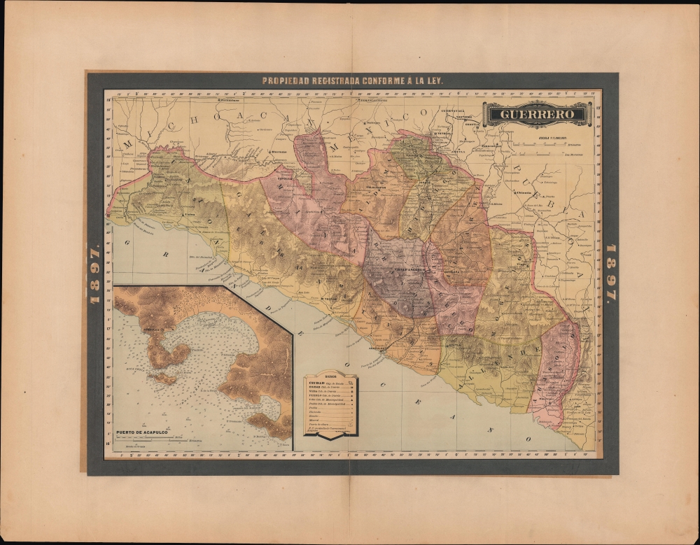
A colorful map of the Mexican state of Guerrero, published in 1897 for the Atlas Geográfico de los Estados Unidos Mexicanos.
The planned railway marked with a dashed line from Yautepec and Cuernavaca (at top) to Acapulco is the Mexico, Cuernavaca and Pacific Railway. This project was about halfway constructed when it was merged into the Mexican Central Railway in 1902. An alternative route, the Ferrocarril Interoceánico de México (not seen here), was meant to connect Acapulco to Vera Cruz via Mexico City but was never extended beyond the Balsas River.
An inset of the port of Acapulco appears at bottom-left, with soundings, shoals, rocks, and hazards indicated. The port's fortunes waxed and waned over time. It was a key node in the global Spanish galleon network and then was burned down during the Mexican War of Independence and again destroyed, this time by an earthquake in 1852. But the California Gold Rush and its aftermath helped the city recover, as travelers bound for California from Panama stopped over at Acapulco.
A Closer Look
The state's subdivisions (districts and municipalities) are color shaded for easy distinction. Both within and beyond Guerrero, cities and towns, haciendas and ranchos, ports, roads, a planned railway, waterways, and mines are labeled. Cutting across the state is the Rio de las Balsas or Rio Atoyac, among the longer rivers in Mexico.The planned railway marked with a dashed line from Yautepec and Cuernavaca (at top) to Acapulco is the Mexico, Cuernavaca and Pacific Railway. This project was about halfway constructed when it was merged into the Mexican Central Railway in 1902. An alternative route, the Ferrocarril Interoceánico de México (not seen here), was meant to connect Acapulco to Vera Cruz via Mexico City but was never extended beyond the Balsas River.
An inset of the port of Acapulco appears at bottom-left, with soundings, shoals, rocks, and hazards indicated. The port's fortunes waxed and waned over time. It was a key node in the global Spanish galleon network and then was burned down during the Mexican War of Independence and again destroyed, this time by an earthquake in 1852. But the California Gold Rush and its aftermath helped the city recover, as travelers bound for California from Panama stopped over at Acapulco.
Publication History and Census
This map was published in Mexico City in 1897 by Vega y Cie. It is based on the 1886 work of Antonio García Cubas and was updated with additional border work for the 1897 issue of the Atlas Geográfico de los Estados Unidos Mexicanos. The atlas is represented in several institutional collections but is extremely scarce on the market. The individual maps, likewise, are scarce to the market.Cartographer
Antonio Garcia y Cubas (July 24, 1832 - February 9, 1912) was a Mexican cartographer, writer, engineer, and geographer active in Mexico City in the second half of the 19th and the early 20th centuries. He is considered Mexico's first great geographer. Garcia y Cubas was born in Mexico City. He was orphaned at birth and was raised by is aunt. When he turned 18, he enrolled in the Dirección General de Industria, a government sponsored technical school. There he studied engineering and geography, which he further pursued at the Colegio de San Gregorio, Colegio de Ingenieros. He graduated with honors in geography and from 1856, became a member of the Sociedad Mexicana de Geografía y Estadística. His geographical work earned him the Order of Guadalupe, a Mexican second empire honorific, directly from the Emperor Maximillian. He published several atlases, including his important Atlas Geográfico, Estadístico e Histórico de la República Mexicana, and multiple decorative chromolithograph Atlas Pintoresco e Históricos covering Mexico, Cuba, Spain, and elsewhere. Today his work is scarce and highly desirable. More by this mapmaker...
Source
García Cubas, Antonio, Atlas Geográfico de los Estados Unidos Mexicanos, (Mexico City: Vega) 1897.
Atlas Geográfico de los Estados Unidos Mexicanos is a grand-format folio atlas of Mexico. It is based largely upon the Atlas Geográfico y Estadístico de los Estados Unidos Mexicanos published in 1887 by Antonio García Cubas and Debray. The present atlas incorporates the same maps, but adds a dramatic silver and gold border, which obscures the 1886 García Cubas imprint. It was issued during Porfirio Díaz's third term as president of Mexico - a period marked by rapid expansion of infrastructure and industry, including railroads, mines, bridges, roads, and broad scale electrification and waterworks. The atlases title page in this 1897 edition, celebrates Diaz with a large portrait and dedication. We have identified at least two editions of this atlas, both bearing the 1897 date: one by Cadena y Cie, features a red title page, another by Vega y Cie, featuring a blue title page. All 1897 editions we have identified have the silver borders, but these seem to be overprinted to cover an earlier gold border, with unidentifiable text and dating behind. We have been unable to find any examples with only the gold border. The atlases in general are showpieces of Mexican lithography in the golden age of the Porfiriato.
Condition
Very good. Even overall toning. Some centerfold discoloration.
References
Rumsey 5758.014 (1886 Edition).