This item has been sold, but you can get on the Waitlist to be notified if another example becomes available, or purchase a digital scan.
1889 (1908) Navy Hydrographic Office Chart of the Gulf Coast, New Orleans to Key West
GulfCoast-hydrographic-1908$250.00


Title
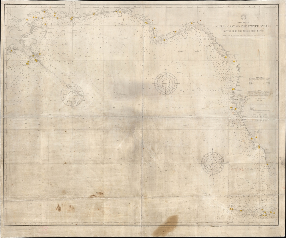
North America Gulf Coast of the United States Key West to the Mississippi River.
1908 (dated) 35 x 42 in (88.9 x 106.68 cm) 1 : 910000
1908 (dated) 35 x 42 in (88.9 x 106.68 cm) 1 : 910000
Description
A scarce and impressive chart or nautical map of the U.S. coast of the Gulf of Mexico from the Mississippi River to the Florida Keys, originally produced by the U.S. Navy Hydrographic Office in 1889 and updated to 1908. It reflects improvements in hydrography and bathymetry, noting fathoms to a considerable depth in open ocean, as well as the development of the coast itself, with a proliferation of lighthouses. Moreover, it manifests several handwritten annotations and wear consistent with extensive use at sea.
A Closer Look
Coverage includes the entire coast of the Gulf of Mexico from the Mississippi River Delta at left to the Florida Keys at bottom-right, taking in the cities of New Orleans, Mobile (included using a wonderful cut out in the top margin), Tampa, and Key West, among others. All along the coast, a wide range of features are indicated, from fathoms, shoals, and hazards to lighthouses (shaded yellow), beacons, buoys, and fog bells. Bathymetric technology and hydrographic surveys of these waters had both advanced to the point that detailed information on the type, color, and quality of the ocean floor could be indicated, according to the abbreviation tables at right, at the coast and well out into deep ocean water. Pencil annotations trace direct routes taken by this chart's owner between Key West and New Orleans.Publication History and Census
This chart was produced by the U.S. Navy's Hydrographic Office in 1889, with updates and corrections added regularly afterwards, with the present edition being published in 1908. The full list of corrections and additions can be seen at bottom-left, while a nearby stamp indicates that the chart was issued in January 1912. The OCLC notes only one example of the 1889 chart in institutional collections, held by the Boston Public Library. A later edition of the chart (OCLC 759929423), printed in 1942, is held by Boston Public Library and Duke University. This chart is noted as being compiled from charts of the U.S. Coast Survey, and indeed the Library of Congress holds a three-piece chart (Call No. G3862.C6 1863 .U52) dated 1863 (concurrent with the U.S. Civil War), with the chart seen here divided in half and a third part including the western portion of the Gulf to Port Isabel, Texas, indicating that the present chart represents two-thirds of a triptych.CartographerS
United States Hydrographic Office (1866 - 1962) was a brach of he U.S. Navy that prepared and published maps, charts, and nautical books to aid in navigation. Before the establishment of the Hydrographic Office in 1866, U.S. navigators were almost entirely dependent on British charts. There had been a few private enterprises that had prepared and published charts, but none had been able to do so profitably. The Office was established 'for the improvement of the means of navigating safely the vessels of the Navy and of the mercantile marine, by providing, under the authority of the Secretary of the Navy, accurate and cheap nautical charts, sailing directions, navigators, and manuals of instructions for the use of all vessels of the United States, and for the benefit and use of navigators generally.' This way the Navy Department could furnish navy and merchant ships with charts illustrating the results of surveys and explorations undertaken by naval officers. The charts were priced to cover the cost of paper and printing alone, not preparation. Its main objective was to survey foreign coasts, as the Coast and Geodetic Surveys were responsible for surveying domestic waters. The Hydrographic Office was transferred from the Department of the Navy to the Department of Defense in 1949 and was replaced by the Naval Oceanographic Office in 1962. More by this mapmaker...
The Office of the Coast Survey (1807 - present) founded in 1807 by President Thomas Jefferson and Secretary of Commerce Albert Gallatin, is the oldest scientific organization in the U.S. Federal Government. Jefferson created the "Survey of the Coast," as it was then called, in response to a need for accurate navigational charts of the new nation's coasts and harbors. The spirit of the Coast Survey was defined by its first two superintendents. The first superintendent of the Coast Survey was Swiss immigrant and West Point mathematics professor Ferdinand Hassler. Under the direction of Hassler, from 1816 to 1843, the ideological and scientific foundations for the Coast Survey were established. These included using the most advanced techniques and most sophisticated equipment as well as an unstinting attention to detail. Hassler devised a labor intensive triangulation system whereby the entire coast was divided into a series of enormous triangles. These were in turn subdivided into smaller triangulation units that were then individually surveyed. Employing this exacting technique on such a massive scale had never before been attempted. Consequently, Hassler and the Coast Survey under him developed a reputation for uncompromising dedication to the principles of accuracy and excellence. Unfortunately, despite being a masterful surveyor, Hassler was abrasive and politically unpopular, twice losing congressional funding for the Coast Survey. Nonetheless, Hassler led the Coast Survey until his death in 1843, at which time Alexander Dallas Bache, a great-grandson of Benjamin Franklin, took the helm. Bache was fully dedicated to the principles established by Hassler, but proved more politically astute and successfully lobbied Congress to liberally fund the endeavor. Under the leadership of A. D. Bache, the Coast Survey completed its most important work. Moreover, during his long tenure with the Coast Survey, from 1843 to 1865, Bache was a steadfast advocate of American science and navigation and in fact founded the American Academy of Sciences. Bache was succeeded by Benjamin Pierce who ran the Survey from 1867 to 1874. Pierce was in turn succeeded by Carlile Pollock Patterson who was Superintendent from 1874 to 1881. In 1878, under Patterson's superintendence, the U.S. Coast Survey was reorganized as the U.S. Coast and Geodetic Survey (C & GS) to accommodate topographic as well as nautical surveys. Today the Coast Survey is part of the National Oceanic and Atmospheric Administration or NOAA as the National Geodetic Survey. Learn More...
Condition
Average. Staining and soiling throughout, toning across surface. Original fold lines visible. Restored and backed on linen.
References
OCLC 317740362.