This item has been sold, but you can get on the Waitlist to be notified if another example becomes available, or purchase a digital scan.
1836 Felipe Bauza Map of the Gulf of Mexico, Florida, and the Bahamas
GulfofMexicoFlorida-bauza-1836$1,500.00

Title
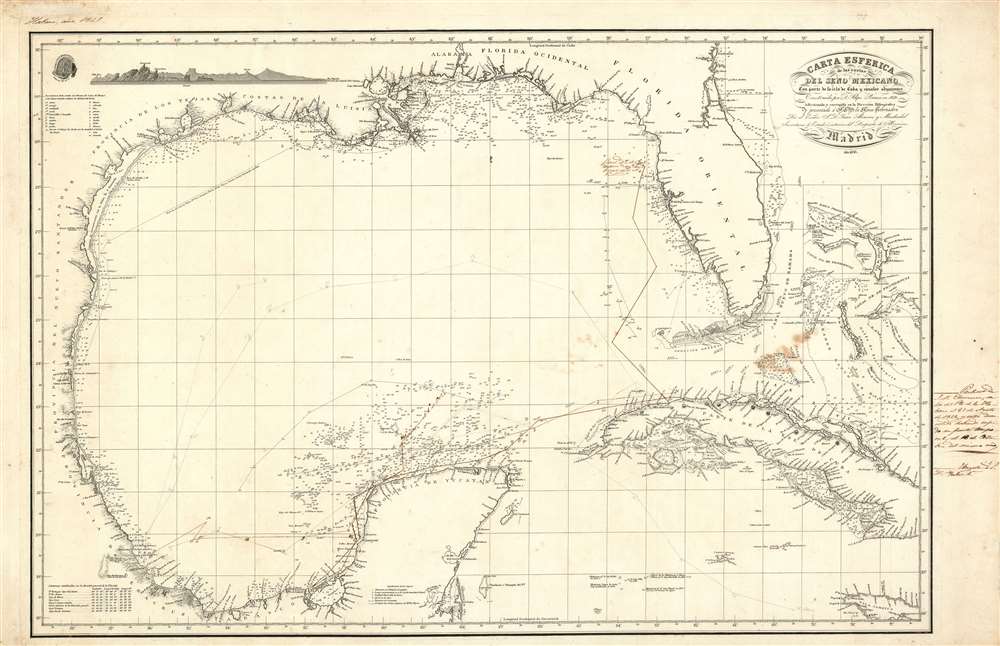
Carta Esferica de la costas del seno Mexicano Con parte de la isla de Cuba y canales adjacentes.
1836 (dated) 25 x 39 in (63.5 x 99.06 cm) 1 : 2570000
1836 (dated) 25 x 39 in (63.5 x 99.06 cm) 1 : 2570000
Description
This is a finely engraved and rare 1836 Spanish Depósito Hidrográfico nautical chart or maritime map by Felipe Bauzá detailing the western Caribbean, the Gulf of Mexico, Florida, the Bahamas, and Cuba. The chart contains interesting manuscript annotations regarding Spanish naval traffic in the region and a defaced London imprint, indicative of political turmoil in Spain and the author's exile.
Bauzá and Alvarez fled to England, where they had many acquaintances and where Bauzá was elected a member of the Royal Society. He took his geographical materials with him and prepared several charts, including this one, for publication in London. Although we have not been able to trace surviving examples published in London, the map was at least initially engraved there. The bottom center London imprint is defaced (from the plate) on all known examples, suggesting that the plates were returned to Spain with Bauzá's effects following his death in 1834, and thus revised and printed in Madrid by the Depósito Hidrográfico.
Known examples survive in institutional collections at the University of Texas, Arlington, and at the Institut Cartogràfic I Geològic de Catalunya. There is no record of this map previously appearing on the private market.
Manuscript Notes: Churacca and Isabel II
Manuscript notes and annotations illustrate the tracks of two ships. A solid line represents the track of the Churacca, a 132-ton brigantine or pailebot based in Havana, that ran the packet route, noted here between Veracruz and Havana. The second, a dotted line, traces the course of the frigate or fragata Isabel II, the flagship of the Spanish Havana fleet. Annotations describe how the Churacca was caught in a hurricane in 1842 and driven northward along the coast of Florida to the vicinity of Tampa. It was evidently saved with the assistance of an Irish ship, and returned to Havana, where, in rough condition, it was sold.Intriguing Erased London Imprint
A curious imprint appearing at bottom center, although defaced and hard to read, suggests the map may have been published in London. This is a reference to the cartographer Bauzá's exile in London following his persecution in Spain for supporting the revolution of Rafael de Riego and the subsequent Trienio Liberal. This was a 3-year period in Spanish history wherein a January 1820 military coup led to the rise of a liberal constitutional government, forcing King Ferdinand VII to accept the Spanish Constitution of 1812. In 1823, with the approval of the crowns of Europe, the French army invaded, abolished the constitution, and reinstated Ferdinand VII's absolute monarchal authority. Leading figures of the Trienio Liberal, including Bauzá and Juan Alvarez y Mendizabal (also mentioned in title), were tried and sentenced to death.Bauzá and Alvarez fled to England, where they had many acquaintances and where Bauzá was elected a member of the Royal Society. He took his geographical materials with him and prepared several charts, including this one, for publication in London. Although we have not been able to trace surviving examples published in London, the map was at least initially engraved there. The bottom center London imprint is defaced (from the plate) on all known examples, suggesting that the plates were returned to Spain with Bauzá's effects following his death in 1834, and thus revised and printed in Madrid by the Depósito Hidrográfico.
Publication History and Census
Published in Madrid in 1836 based upon cartography completed by Felipe Bauzá in 1829 under the orders of Juan Alvarez y Mendizabal, also a supporter of the Trienio Liberal and exiled in London. There remains a scratched-out imprint at the bottom of the map indicating a London publication. This suggests that there was an earlier London edition, but we have not been able to definitively trace such, and believe it may never have been printed.Known examples survive in institutional collections at the University of Texas, Arlington, and at the Institut Cartogràfic I Geològic de Catalunya. There is no record of this map previously appearing on the private market.
CartographerS
Felipe Bauzá y Cañas (February 17, 1764 - March 3, 1834) was a Spanish cartographer, navigator, and naval officer active in the late 18th and early 19th centuries. Bauzá was born on the Balearic Islands in the Mallorcan city of Palma. He attended the Spanish maritime college in Cartagena, Spain. He saw action during the Siege of Gibraltar (1779 - 1782), the capture of Port Mahón, and a campaign against the Moors (1783 - 1784). Exhibiting a proficiency in mathematics and draftsmanship, he subsequently trained as a hydrographer and cartographer under Vicente Tofiño (1732 – 1795), the premier Spanish nautical chartmaker of the day. Bauzá was the head cartographer on the Malaspina Expedition (1789 - 1794) to the Americas, Oceania, and Australasia. From 1797, he worked with the Depósito Hidrográfico / Dirección Hidrografica in Madrid, becoming head of said organization in 1815. Renowned as a cartographer, he was honored with the Russian Cross of St. Vladimir in 1816 and was elected a Foreign Member of the Royal Society of London in 1819. From about 1800, he began assembling a personal collection of maps and charts intended to form the backdrop of a series of definitive maps of Latin America. Political fate intervened with his plan. Bauzá was a supporter and leader of the of Rafael de Riego Revolution in 1920, and served the Cortes Generales during the Trienio Liberal ('Three Liberal Years', 1820 - 1823), as the deputy for Mallorca. After the fall of that regime, in 1823, he was sentenced to death by King Ferdinand VII. Bauzá fled to England in that year, taking with him his nautical charts and other geographical source materials. Bauzá and his family struggled in London, attempting to support themselves by publishing his cartography and selling parts of his collection to the British Admiralty's Hydrographic Office. His death sentence was finally commuted in 1833, but before he could return to Spain, he died of a brain hemorrhage. He family was left in destitution and his widow Teresa Rivera y Bauzá, made ends meet by selling his map collections. Some went to foreign governments (Venezuela) but most are not part of the Bauzá collection in the British Library. More by this mapmaker...
The Direccion Hidrografía (1787 - 1927), also known as the Deposito Hydrografico and the Direction de Hidrografía, was the Spanish equivalent of the British Admiralty or the U.S. Coast Survey. This organization, founded in 1787, was commissioned to collect and produce accurate nautical charts of all waters frequented by Spanish vessels. In essence, it replaced the Casa de la Contratación de las Indias (House of Trade of the Indies), which closed its doors in 1790. Like most such organizations, the Direccion Hidrografía marked a new age in cartography. Rather than simply collect charts created by navigators, explorers, and merchants, the Direccion Hidrografía worked closely with naval and military personnel to mount cartographic and hydrographic expeditions in pursuit of the most accurate hydrographical, astronomical, and geodetic measurements. The Direccion Hidrografía created a massive library of nautical charts that, though not nearly as common as similar nautical charts by the U.S. Coast Survey and British Admiralty, are highly desirable for the beauty of their manufacture as well as their accuracy and detail. The office was originally located on Calle Ballesta, but relocated to 36 Alcala, both in Madrid. After 1908 the Dirección was subsumed into other governmental agencies. In 1927 the Direccion was absorbed into the Institute and Observatory of San Fernando, located in Cadiz. The library of original maps, charts, and journals was transferred to the Naval Museum of Madrid - where it resides to this day. Learn More...
Condition
Very good. Some minor discolorations. Manuscript annotations in ink.
References
OCLC 556602383.