1889 Jesuit Havret Map of Shanghai Region: Nantong (南通), Hai-men (海门), and Chongming (崇明
HaiMen-havret-1889$3,000.00

Title
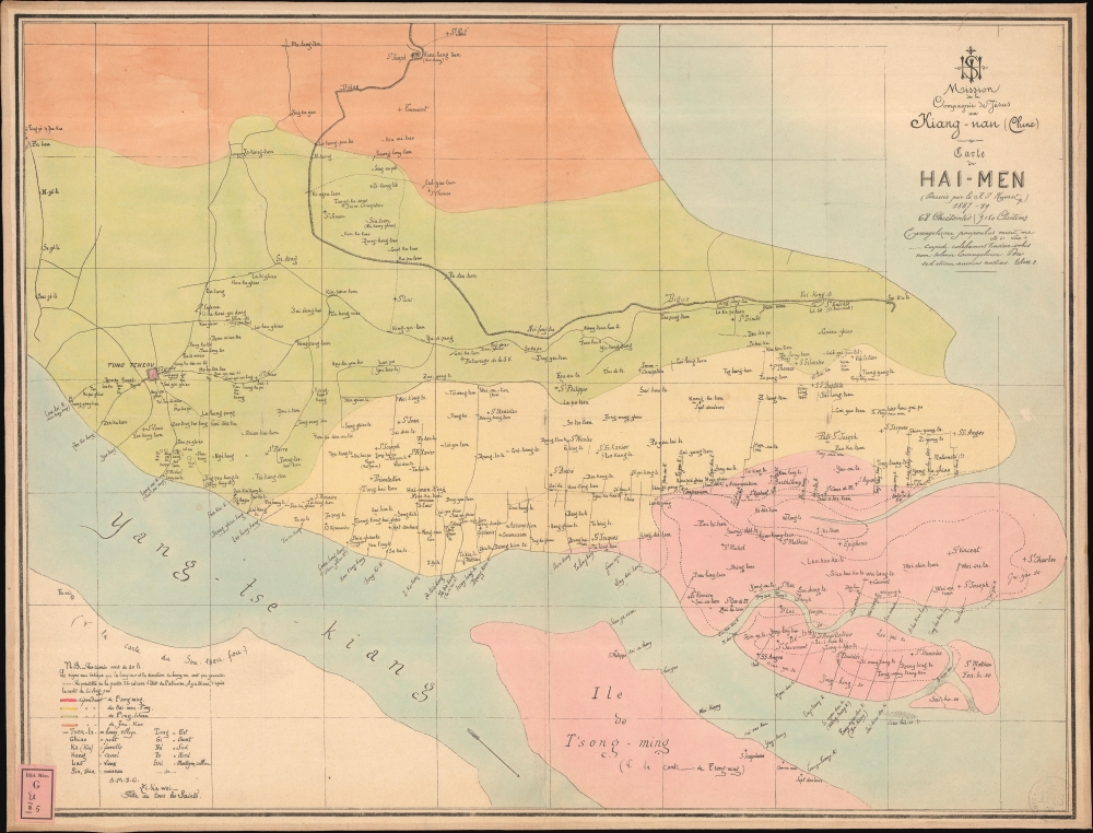
Mission de la Compagnie de Jesus au Hiang-Nan (Chine). / Carte de Hai-Men (Dressee par le R.J Havret) 1887-89.
1889 (dated) 23.5 x 18 in (59.69 x 45.72 cm)
1889 (dated) 23.5 x 18 in (59.69 x 45.72 cm)
Description
This is a c. 1889 French Jesuit map of Nantong (南通), Hai-men (海门), and the island of Chongming (崇明岛), on the opposite side of the Yangtze River from Shanghai, China. It is one of the maps produced at the Xujiahui Library (Zi-ka-wei) by the Jesuit priest Henri Havret for his 1892 study of the historical formation and settlement of the alluvial Chongming (Tsong Ming) Island. The map also serves as a unique record of Missionary activity near Shanghai, recording the sites of hundreds of new churches and missions.
This map was produced for Henri Havret's 1892 study of the formation and settlement of the alluvial Chongming (Tsong Ming) Island. This was the first work to examine Chongming's growth over hundreds of years by incorporating data from both Chinese and Western sources. Accordingly, dotted lines represent the alluvial shorelines some 25 years ago, as recorded by the Chinese diplomat and cartographer 'Li-fong Pao' (Li Fengbao; 李凤苞; 1834 - 1887).It superseded and contradicted the results of earlier studies on Chongming done by French geographer Jacques Élisée Reclus (1830 - 1905). While produced in conjunction with Havret's study, this map was not included in his published report L'île de Tsong-Ming à l'embouchure du Yang-Tse-Kiang, and was issued separately.
A Closer Look
Coverage embraces the southeastern parts of Jiangsu (江苏) Province, including the districts of Nantong (南通), Hai-men (海门), and the island of Chongming (崇明岛). The map illustrates numerous villages, churches, and missions throughout. The title celebrates the regional success of the Kiang-nan missionaries between 1887 and 1889 - expanding from 68 to 9,150 Christians. One could argue, with its close proximity to Shanghai, that Nantong was fertile ground for Catholic conversion, but a subsequent decrease in Christianity throughout the region suggests wide but shallow religious penetration. A key in the lower left includes a brief dictionary of transliterated Chinese geographical terms.This map was produced for Henri Havret's 1892 study of the formation and settlement of the alluvial Chongming (Tsong Ming) Island. This was the first work to examine Chongming's growth over hundreds of years by incorporating data from both Chinese and Western sources. Accordingly, dotted lines represent the alluvial shorelines some 25 years ago, as recorded by the Chinese diplomat and cartographer 'Li-fong Pao' (Li Fengbao; 李凤苞; 1834 - 1887).It superseded and contradicted the results of earlier studies on Chongming done by French geographer Jacques Élisée Reclus (1830 - 1905). While produced in conjunction with Havret's study, this map was not included in his published report L'île de Tsong-Ming à l'embouchure du Yang-Tse-Kiang, and was issued separately.
Chongming Island
Chongming Island (Tsong Ming; 崇明岛), located just north of Shanghai, China, is a remarkable example of geographical and historical evolution. Formed from the alluvial deposits of the Yangtze River, the island's growth over centuries has been a slow and natural process, heavily influenced by the sedimentary contributions of the river. Initially a collection of separate shoals, these alluvial islands gradually merged, forming a habitable landmass by the Ming Dynasty. Human settlement, while dating to ancient times, became more significant under the Ming and Qing, when large-scale dyke construction stabilized the island. Its strategic location at the mouth of the Yangtze made it significant for trade and military purposes.Nantong (南通)
Nantong is located in the Jiangsu Province of China, just north of Shanghai. The district was strategically situated near the mouth of the Yangtze River, in close proximity to the international concessions in nearby Shanghai. In the 19th century, Nantong's proximity to Shanghai provided trade and technological advantages over other parts of China, leading to early agricultural and industrial development - particularly in the textile industry. Under the influence of the 'official-entrepreneur' Zhang Jian (1853 - 1926), Nantong developed a modern textile industry with progressive policies. Zhang founded the first modern cotton mill in China here, laying the groundwork for Nantong's reputation as a textile cente.Provenance
The map bears two library stamps, confirming it was deaccessioned by a German Jesuit library sometime in the 1980s. The library stamp remains in the lower left, and its mark appears in the lower right. It is difficult to decipher but reads 'Prov. Germ. S. J.', resolvable to 'Provinciae Germaniae Bibliotheca Scriptorum Societatis Jesu', perhaps located in Cologne. We have seen numerous other maps with the same stamps, all very rare, many unique manuscripts, so the deaccession must have been significant. A German dealer acquired the deaccessioned maps, and pieces with similar marks occasionally appear on the market, representing all parts of the world.Publication History and Census
This map was compiled c. 1889 by Henri Havret and issued by the Roman Catholic Apostolic Vicariate of Kiang-nan, a missionary jurisdiction in mainland China, comprising the Chinese provinces of Jiangsu (江苏) and Anhui (安徽). It was printed at the Xujiahui Library (Zi-Ka-Wei;上海图书馆徐家汇藏书楼), just southeast of Shanghai. This is the only known surviving example.CartographerS
Henri Havret (November 15, 1848 - September 29, 1902) was a French Jesuit priest, missionary, sinologist, and Latinist active in China in the last quarter of the 19th century. There is some confusion as some of his works are signed 'R. P. Havret', (often written sloppily, appearing nearer to R. J.), this being his honorific, 'Reverendus Pater' (Reverend Father), not part of his name. Havret was born in Wassy, Haute-Marne, France. He joined the Society of Jesus in 1872 and was immediately sent to China, where he underwent his theological studies and was, in 1874, ordained into the priesthood. He was placed in charge of the Xujiahui Library (Zi-Ka-Wei;上海图书馆徐家汇藏书楼), located southwest of Shanghai, and taught philosophy at the local Saint-Ignace College. Later he dedicated himself to proselytizing in the lower Yangtze. In the tradition of Jesuit scholar-priests, he produced several significant studies, including a scientific analysis of the creation and settlement of Chongming, an alluvial island north of Shanghai, and an 1892 study of the Nestorian Xi'an Stlele, discovered in 1625. Havret was made director of the Xujiahui Seminary in 1894, a position he held until 1898. He died four years later, in 1902, in Xujiahui, China. More by this mapmaker...
Xujiahui Library (1847 - Present), today known as the Shanghai Library Bibliotheca Zi-Ka-Wei (上海图书馆徐家汇藏书楼) was established in 1847. It was initially part of the Jesuit mission complex in the Xujiahui village (徐家汇), situated on the outskirts of Shanghai. Following the Jesuit mission of scholarship, it evolved into an academic center embracing both Chinese and Western academic heritages. It was also an important publishing house, issuing maps, religious works, scholarly studies, and more. By the end of the 19th century, it housed over 200,000 volumes. The library is known for its comprehensive collection of Chinese gazetteers, newspapers, reference materials, and mission-related publications. The establishment of the People's Republic of China marked the end of the Jesuit mission in Xujiahui. Nonetheless, the library perseveres, having been nationalized and, from 1957, integrated into the Shanghai Library System. Learn More...
Condition
Very good. Laid on original linen. Jesuit library label and stamp.