Digital Image: 1871 Belloguet Allegorical Caricature Map of France
HallucinationTopographique-belloguet-1871_d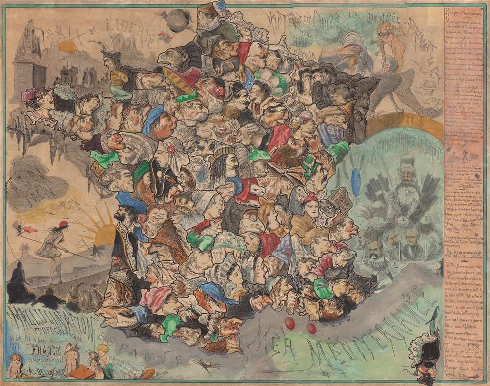

Title
Hallucination topographique sur la carte de France.
1871 (dated) 19.25 x 24.25 in (48.895 x 61.595 cm)
1871 (dated) 19.25 x 24.25 in (48.895 x 61.595 cm)
Description
FOR THE ORIGINAL ANTIQUE MAP, WITH HISTORICAL ANALYSIS, CLICK HERE.
Digital Map Information
Geographicus maintains an archive of high-resolution rare map scans. We scan our maps at 300 DPI or higher, with newer images being 600 DPI, (either TIFF or JPEG, depending on when the scan was done) which is most cases in suitable for enlargement and printing.
Delivery
Once you purchase our digital scan service, you will receive a download link via email - usually within seconds. Digital orders are delivered as ZIP files, an industry standard file compression protocol that any computer should be able to unpack. Some of our files are very large, and can take some time to download. Most files are saved into your computer's 'Downloads' folder. All delivery is electronic. No physical product is shipped.
Credit and Scope of Use
You can use your digial image any way you want! Our digital images are unrestricted by copyright and can be used, modified, and published freely. The textual description that accompanies the original antique map is not included in the sale of digital images and remains protected by copyright. That said, we put significant care and effort into scanning and editing these maps, and we’d appreciate a credit when possible. Should you wish to credit us, please use the following credit line:
Courtesy of Geographicus Rare Antique Maps (https://www.geographicus.com).
How Large Can I Print?
In general, at 300 DPI, you should at least be able to double the size of the actual image, more so with our 600 DPI images. So, if the original was 10 x 12 inches, you can print at 20 x 24 inches, without quality loss. If your display requirements can accommodate some loss in image quality, you can make it even larger. That being said, no quality of scan will allow you to blow up at 10 x 12 inch map to wall size without significant quality loss. For more information, it is best consult a printer or reprographics specialist.
Refunds
If the high resolution image you ordered is unavailable, we will fully refund your purchase. Otherwise, digital images scans are a service, not a tangible product, and cannot be returned or refunded once the download link is used.
Cartographer
André Belloguet (1830 - 1873, c. 188x) was a French artist, caricaturist, and lithographer. Belloguet created numerous political cartoons and satirical maps of France and Europe over the course of his career and collaborated with numerous French magazines. Many featured caricatures with incredible expressions, facial structures, and distinctive hats. Belloguet created a large corpus of work during the Franco-Prussian War, the siege of Paris, and the Paris Commune (1870 - 1871) and examples of some of these works can be found in the poster collection of the Département des Hauts-de-Seine in France. A list of forty works published during this era is included in Maurice Quentin-Bauchart's La caricature politique en France pendant la guerre, le siège de Paris et la Commune published in 1890. Most references for Belloguet cite his death date as 1873. However, Roderick Barron's 2008 article Bringing the map to life: European satirical maps 1845 - 1945 states that Belloguet fled Paris after the Paris Commune in 1871 and settled in Brussels, where he worked for the magazine Le Lutin. Also according to Barron Belloguet published at least one satirical map in Brussels that used animals as personifications for European nations entitled L'Europe Animale, Physiologie Comique in 1882. More by this mapmaker...
References
Affiches anciennes conservées par le département des Hauts-de-Seine 23FI593. OCLC 456931961.