This item has been sold, but you can get on the Waitlist to be notified if another example becomes available, or purchase a digital scan.
1912 Hankow Daily News Map of Hankow / Hankou / Wuhan (after the 1911 fire!)
Hankow-toppan-1912$1,500.00


Title
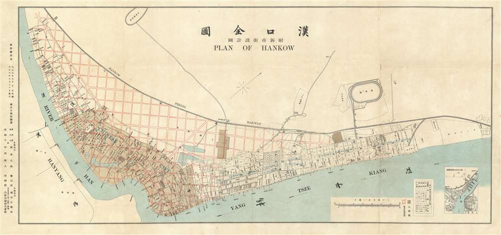
漢囗全圖 / Complete Map of Hankou. / 附新市街設計圖 / Attached Map of New City Street Design.
1912 (dated) 14.25 x 30.5 in (36.195 x 77.47 cm) 1 : 9500
1912 (dated) 14.25 x 30.5 in (36.195 x 77.47 cm) 1 : 9500
Description
This is a rare 1912 Chinese-English bilingual map of Hankow (Hankou), part of modern Wuhan, China. The map was issued by the English-language Hankou based newspaper, Hankow Daily News, shortly following the 1911 burning of Hankou by Qing loyalist forces during the Xinhai Revolution (October 18 - December 1, 1911). Oriented to the northwest, the map covers from the conjunction of the Han and Yangtze Rivers northward to the tracks of the Hankow-Peking Railway or Jinghan Railway (京漢鐵路). The map labels the foreign concessions established to the east of the older Chinese city of Hankou, among them British, Russian, French, German, and Japanese. The lands to the west of the concessions are overprinted with a grand grid structure in red - reflecting plans to rebuild the Chinese part of Hankou after its total immolation one year earlier.
The English journalist Edwin J. Dingle (1881 - 1972) watched the destruction first hand from the walls of the British concession,
Hankow - a city of Merchants
Today Hankou has been absorbed into the modern megapolis Wuhan, but it was then a separate city, distinct from the neighboring administrative and educational cities of Wuchang and Hanyang. It was raised by Taiping forces in the 1850s and nearly abandoned until 1862, when it was declared a treaty port. Five concession areas were subsequently established: Britain (115 acres, est. 1862), France (60 acres, est. 1886), Russia (60 acres, est. 1886), Germany (100 acres, est. 1895) and Japan (32 acres, est. 1898). All five are labeled here. Loosely administered by Hanyang across the river, Hankou rapidly developed as a major center of both domestic and foreign trade. In contrast to its staid and conservative neighbor, Wuchang, Hankou by the late 19th century had developed a reputation for Western-style commercialism, free trade, and lawlessness. Capitalist fortunes were made both by ambitious Chinese merchants and foreign factors living in the concessions.Burning of Hankou
On October 10, 1911, revolutionaries in Wuchang launched the Xinhai Revolution against the Qing Dynasty. They seized the nearby merchant cities of Hankow and Hanyang, both on the north bank of the Yangtze River. The Qing court in Beijing ordered the Beiyang Army, the strongest military unit in Qing China, to lay siege to Hankou. Better armed and numerically superior, the Qing dominated in a series of bloody battled and were able to size Hankow. During the military rule that followed the Qing were constantly harassed by underground guerrilla attacks supported by the local populace. In retaliation, Feng Guozhang, a Beiyang commander, ordered the bombardment and razing of Hankow.The English journalist Edwin J. Dingle (1881 - 1972) watched the destruction first hand from the walls of the British concession,
Can you imagine that in the great dancing prairie fire that you have seen thousands of housetops, minarets, temple spires, roofs of all heights, sizes, and shape - can you? Can you image those wild flames, fanned strongly to one side, and see that might belt of flame galloping furiously onward, then drawing back, then galloping again and gaining ground, the settling finally down as if it had its lucky enemy in its most deadly grasp … The men and terrified women, and the tiny helpless children, the old fathers and the mothers, the invalids, the incapacitated, the blind, the halt, and the maimed had left the city a couple of days before, and now were around the countryside, rich and poor alike being turned out of house and home. Those who doubted, however, or were indifferent were mixed up in the street, helpless, hopeless, waiting for their inevitable doom in that great fire, the great fire of Hankow, the devoted central market of the Chinese world, now lost in doom in the Chinese war. (Dingle, E. J., China's Revolution 1911-1912, pages 81-85)The fire burnt for four days and four nights, killed thousands, and completely destroyed the city. Of old Hankow, only the Concessions and the racetrack survived.
Rebuilding Hankow
Following the burning and the ultimate overthrow of the Qing, the chamber of commerce and Merchant associations of Hankow, led by the influential Cai clan and the merchant Liu Xinsheng, issued a fervent public endorsement of newly established Republic of China and put forth an ambitious reconstruction plan - illustrated here. The plan highlights the burnt areas in brown, with overprinting suggesting an expansive and impressive street grid greatly increasing the size of the city. The grid, which is European in character, stylistically combines the rigid rectilinear grid of New York City with the grid and ray system of Washington D.C. Construction commenced immediately, and Hankou again prospered for nearly twenty years, until it was again utterly destroyed by bombing attacks during World War II.Publication History and Census
This map was published for the Hankow Daily News, an English language newspaper published in Hankow from 1906 to 1912. We have found no evidence of any publication associated with the Hankow Daily News postdating 1912 - suggesting that the publishers, alarmed by the violence of the Xinhai Revolution, abandoned the paper and Hankow. The map was printed by the Japanese firm Toppen (凸版印刷株式會社) or the Letterpress Printing Company, Ltd. The Letterpress Printing Company was perhaps the most advanced printing operation then active in Asia and the only firm with active color offset press - which is how this map was printed. The use of the most advanced printing technology in distant Japan, and high-quality materials underscore the gravity of this map. It is unclear how many may have been produced, but today this map is rare. We have identified no other known examples in any collection public or private.CartographerS
Hankow Daily News (March 15, 1906 - c. 1912) was an English language newspaper published in Hankow in the early 20th century. The newspaper's first issue was released in March of 1906. The paper was founded by the English China coast merchant John Andrew and the German expatriate Otto Marx, who important type and a large press form England. It promised to offer the latest news from British, American, and German telegraph wires as well as local news collected from missionaries in the Yangtze valley. Andrews died in 1907 or 1908 and Marx died shortly 1908, after which ownership and editorship fell to T. Ross-Reid. The paper, among other political positions, advocated for a consolidated International Settlement (like Shanghai) and covered the First Chinese revolution (1911) and the Battle of Hankow from a first person perspective. It consisted of roughly 8 pages, each organized into to 6 columns, with occasional supplements. Publication appears to have ceased around 1912, following the Xinhai Revolution. More by this mapmaker...
Toppan Printing Company (凸版印刷株式會社, 1900 - present) was a printer and lithographic press founded in Meiji Japan in 1900 as Toppan Printing Limited Partnership. The founding of Toppen closely correlates to Meiji efforts to modernize Japan in the late 19th and early 20th centuries. The firm was formally reorganized with an influx of new investment in 1908, taking the name Toppan Printing Co., LTD (凸版印刷株式會社), which literally translates as 'Letterpress Printing Company,' reflecting the company's embrace of the then cutting edge Erhört letterpress method. By 1910, Japan had modernized to such an extent there was a growing need for brightly colored advertising, propaganda, touristic, and commercial printing. Toppen employee Gennojo Inoue split off from the firm to import color offset printing technologies from the United States and Europe, founding the Offset Printing Company in 1913. After four years of successful operation and growing market share, Toppen acquired the technologically superior company and reabsorbed Gennojo Inoue as an executive. Despite the Great Kanto Earthquake of 1923, Japanese efforts at modernization advanced rapidly. Between 1920 and 1929 the company's production and revenue grew dramatically. In 1920 or 1920 photomechanical printing was introduced to Japan, again by the efforts of visionary company president Gennojo Inoue. From the 1930s on, Toppen under Gennojo Inoue's guidance continued to grow, becoming one of the largest printing concerns in Japan. They established offices in other cities, including Osaka. In 1938, they built a large press factory, the Itabashi Plant, in Tokyo. During World War II the Toppen firm was utilized for the war effort, producing new currencies, bonds, government securities, and propaganda material. Following the war, Toppan was reorganized and continued to grow. It is today a major Japanese firm, diversified in multiple industries and traded on the Tokyo Stock Exchange. Learn More...
Condition
Very good. Slight wear on original fold lines.