This item has been sold, but you can get on the Waitlist to be notified if another example becomes available, or purchase a digital scan.
1765 Isaak Tirion Map of Cartagena Harbor, Colombia
HavenCarthagena-tirion-1765$175.00

Title
Plan van de Haven van Carthagena.
1765 (undated) 7.25 x 12.25 in (18.415 x 31.115 cm) 1 : 55000
1765 (undated) 7.25 x 12.25 in (18.415 x 31.115 cm) 1 : 55000
Description
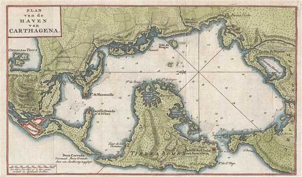
This is a 1765 Isaak Tirion map of Cartagena Harbor, Colombia. Oriented toward the east, the map depicts the region from Cartagena to Polonia and from the northern shore of Cartagena Bay to the Isla de Tierra Bomba. Numerous locations around the bay are labeled, including various settlements around the bay, islands, and forts and castles for defense of the colony. Several forts are located on the Isla de Tierra Bomba, including the Castillo de San Luis van Boca Chica (Castillo de San Luis de Bocachica), which was constructed to guard the entrance to the Bocachica Channel and protect Cartagena. The Fort de Manzanillo, the Castillo Grande of de S. Cruz, and the Fort de San Felipe de Baraxas are among the other castles, forts, and strongholds labeled.
Cartagena (Carthagena) itself is situated on the lower left and is illustrated surrounded by city walls. Per Kip S. Kapp
This map was produced by Isaak Tirion in 1765.
Cartagena (Carthagena) itself is situated on the lower left and is illustrated surrounded by city walls. Per Kip S. Kapp
In the days of discovery and colonisation, the most heavily fortified port inthe New World was Cartagena. This historic city was used as a haven for the galleons laden with the riches of the Andes bound for Spain. Each year, Cartagena de Indias played host to the Plate Fleet and stubbornly defied the haunting pirates that plagued the coast. Skilled artisans were brought over from Sevilla to layout towns and design churches and homes of distinction; in consequence, some of the finest examples of colonial architecture are still to be found amid the narrow streets of this old, walled city. Cartagena was under constant threat from the pirates and privateers who roamed the Caribbean in past centuries and, for protection, elaborate fortresses were built to line the harbour and its approaches. (Kapp, K.S., The Early Maps of Colombia up to 1850, The Map Collectors' Circle, no. 77, 1971)Numerous features of the land surrounding the bay are illustrated including trees, that appear to be plantations, and tree-lined fields, which most likely indicates private ownership of the fields. Roads crisscross the landscape and, as stated above, numerous small villages appear along the roads and at intersections. Depth soundings are included throughout the bay.
This map was produced by Isaak Tirion in 1765.
Cartographer
Isaak Tirion (1705 - 1765) was a Dutch publisher in Amsterdam. Born in Utrecht, Tirion quickly rose to prominence by publishing pamphlets, historical works, and most importantly, maps and atlases. He produced several atlases and Dutch town plans. His maps are mainly based on those of Guillaume de l'Isle. Tirion eventually relocated his printing house to the prestigious Kalverstraat. In his long career, he produced eight atlases in multiple editions, some of which were published posthumously until about 1784. More by this mapmaker...
Condition
Very good. Blank on verso.
References
OCLC 783801588.