This item has been sold, but you can get on the Waitlist to be notified if another example becomes available, or purchase a digital scan.
1891 U.S. Coast Survey Map of New York City: Harlem River, Hell Gate, Roosevelt Island
HellGateRooseveltIsland-uscs-1891$437.50

Title
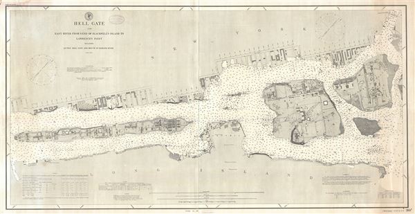
Hell Gate and East River from S. End of Blackwell's Island to Lawrence's Point including Little Hell Gate and Mouth of Harlem River.
1891 (dated) 27 x 53 in (68.58 x 134.62 cm) 1 : 5000
1891 (dated) 27 x 53 in (68.58 x 134.62 cm) 1 : 5000
Description
An extremely scarce and important 1891 nautical chart or maritime map depicting New York City's Hell Gate, the East River, the Harlem River, Roosevelt Island (Blackwell's Island), Ward's Island, and Randall's Island, as well as portions of adjacent Manhattan, Brooklyn, and Queens. As suggested by the title, the map focuses on the East River from the southern tip of Roosevelt Island northwards to the northern tip of Randall's Island and the Harlem River. The three islands are particularly well mapped with superb inland detail with individual buildings and roadways identified. The Queens and Manhattan portions of the map are detailed only along the riverside.
The real focus of the map is the river itself. The passage between Roosevelt Island and Ward Island was first named Helegat, meaning 'bright passage', by the Dutch Explorer Adriaen Block in 1614. When the English moved in it was Anglicized to Hell Gate, arguably a more appropriate term since the shoals and the violent swirling tidal flux proved the demise of many ships. To sailors the gate appeared as 'a giant whirlpool, punctuated with rocks, reefs, and islands. To a sea captain worth his salt, it must have appeared as a gate to Hell' (The Conquest of Hell's Gate, U.S. Army). Countless ships were lost here inspiring the Army Corps of Engineers to undertake the incredible project of deepening the channel and blowing up the reefs. In 1885 the Great Blast of Flood Rock, the largest manmade explosion before the Atomic Bomb, destroyed Flood Rock (still depicted here). The debris from the explosion was subsequently cleared out and used to fill the narrow channel between Randall's Island and Ward's Island, as well as the 'sunken garden', creating a single large island. Subsequently, this important channel became easily navigable and trade consequently increased dramatically.
Though the U.S. Coast Survey issued this map well after demolition crews blew up the reefs and shoals near Ward's Island as well as Flood Rock, most of these reefs are still shown, suggesting that it may have been nearly useless to a navigator. This may well explain its extraordinary scarcity. Only two other examples are known, both of a later date, and both held in institutional collections. These include one example (G3802.H4 P531895.U5) dated 1895 at the University of Illinois at Urbana-Champaign Library, and another example (G3804 .N4 P5 1892 .U4) dated 1892 at Stanford University. It also does not appear in Haskell.
According to the maps' imprint it was first published in 1887, the present example being updated to April of 1891 under the supervision of Thomas Corwin Mendenhall, superintendent of the U.S. Coast and Geodetic Survey. The triangulation was completed by E. Blunt and G. Bradford. The topography is the work of H. Hergesheimer. The hydrography was accomplished by J. M. Hawley and C. P. Perkins. Most of this work was completed between 1885 and 1886. Although earlier examples may theoretically exist, the above is the earliest known surviving example and the only such in private hands. Represents coast chart no. 3695.
Cartographer
The Office of the Coast Survey (1807 - present) founded in 1807 by President Thomas Jefferson and Secretary of Commerce Albert Gallatin, is the oldest scientific organization in the U.S. Federal Government. Jefferson created the "Survey of the Coast," as it was then called, in response to a need for accurate navigational charts of the new nation's coasts and harbors. The spirit of the Coast Survey was defined by its first two superintendents. The first superintendent of the Coast Survey was Swiss immigrant and West Point mathematics professor Ferdinand Hassler. Under the direction of Hassler, from 1816 to 1843, the ideological and scientific foundations for the Coast Survey were established. These included using the most advanced techniques and most sophisticated equipment as well as an unstinting attention to detail. Hassler devised a labor intensive triangulation system whereby the entire coast was divided into a series of enormous triangles. These were in turn subdivided into smaller triangulation units that were then individually surveyed. Employing this exacting technique on such a massive scale had never before been attempted. Consequently, Hassler and the Coast Survey under him developed a reputation for uncompromising dedication to the principles of accuracy and excellence. Unfortunately, despite being a masterful surveyor, Hassler was abrasive and politically unpopular, twice losing congressional funding for the Coast Survey. Nonetheless, Hassler led the Coast Survey until his death in 1843, at which time Alexander Dallas Bache, a great-grandson of Benjamin Franklin, took the helm. Bache was fully dedicated to the principles established by Hassler, but proved more politically astute and successfully lobbied Congress to liberally fund the endeavor. Under the leadership of A. D. Bache, the Coast Survey completed its most important work. Moreover, during his long tenure with the Coast Survey, from 1843 to 1865, Bache was a steadfast advocate of American science and navigation and in fact founded the American Academy of Sciences. Bache was succeeded by Benjamin Pierce who ran the Survey from 1867 to 1874. Pierce was in turn succeeded by Carlile Pollock Patterson who was Superintendent from 1874 to 1881. In 1878, under Patterson's superintendence, the U.S. Coast Survey was reorganized as the U.S. Coast and Geodetic Survey (C & GS) to accommodate topographic as well as nautical surveys. Today the Coast Survey is part of the National Oceanic and Atmospheric Administration or NOAA as the National Geodetic Survey. More by this mapmaker...
Condition
Very good. Two sheets joined at center. Some toning.
References
University of Illinois at Urbana-Champaign Library, G3802.H4 P531895.U5. Stanford University, Branner Earth Sciences Library, G3804 .N4 P5 1892 .U4.