
1876 Hayami Wall Map of the World in Hemispheres

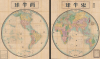
東半球 / Eastern Hemisphere / 西半球 / Western Hemisphere.
Japan's view of the world, and its place, with some exaggeration.
- Digital Map Information
- Suitable for large format printing
- File Size: 455.86 MB
- File Type: ZIP / TIFF
- ICC color profile embedded
- Delivered instantly via download link
Japan's view of the world, and its place, with some exaggeration.
This is a very scarce and enormous Meiji 9 or 1876 Japanese double hemisphere world map set by Hayami Iwakichi. Aside from its sheet immensity, the map is notable for reflecting changing Japanese understanding of world geography in the fallout from the Meiji Restoration. Hayami offers a very Japanese worldview superimposed upon a modern world map, with some places are diminished and others exaggerated in size to reflect not only their importance to Japan, but also Japan's perspective regarding its own position on the world stage.A Closer Look
Composed of two gigantic panels, each measuring 75 x 62 inches (more than 6 x 10 feet when laid side by side!), this map covers the world on a hemispherical projection. Although the map includes latitude, longitude, the Equator, tropics, and Arctic and Antarctic circles, it does not measure longitude from Greenwich or any other Prime Meridian, allowing for the convenience of including Africa and Europe on the Eastern Hemisphere sheet. Japan is highlighted in bright red, while other countries and territories are more subtly shaded. Cities, major rivers, mountains, maritime routes, and national and continental boundaries are noted.Hayami offers a very Japanese worldview superimposed upon a modern world map. Some places are diminished and others exaggerated in size to reflect not only their importance to Japan, but also Japan's perspective regarding its own position on the world stage. Both the Ryukyu and Kuril Islands (千島列島) are included as part of Japan, reflecting recent and still-tenuous colonization efforts, while Sakhalin (Karafuto) is not. This arrangement reflects the terms of the 1875 Treaty of St. Petersburg, wherein Japan traded its claims on Sakhalin in exchange for the Kuril Islands. Even still, the northernmost Kuril Islands do admit to the remnant presence of 'Western foreigners' (西洋人, i. e. Russians).
Korea is disproportionally small when compared to Japan and its internal geography is only lightly sketched, though a detailed note does appear off the east coast of Korea discussing an impending treaty (the Japan-Korea Treaty or Treaty of Ganghwa Island, often seen as the opening phase of Japan's bid to colonize its neighbor). Next door, Qing sovereignty (which Japan viewed with increasing disdain) is not even recognized, with its territory instead being divided into its component parts of China, Manchuria, Mongolia, Xinjiang, and Tibet. Taiwan is also conspicuously shaded distinctly and is named with kana (タイワン) instead of kanji (臺灣), perhaps for ease of reading but also perhaps as a political statement to emphasize its separation from China. The Chinese port of Ningbo (寧波 / ニンボー), historically an important point of communication between Japan and China and one where Japanese traders had an increasingly prominent presence at this time, is also known by the same kana.
Hawaii (Sandwich Islands / 三維斯島), by contrast, is proportionally enormous, likely reflecting perceived strategic importance in the future (maritime routes linking Japanese ports to San Francisco via Hawaii already being traced here).
Most countries are illustrated as a block, with no internal states or divisions indicated, though some are included randomly (perhaps where space permitted), such as Florida (フロリダ半島). Also exceptional in this regard is Australia, which has been divided here into its constituent colonies. Other oddities appear, most likely reflecting misunderstandings or limited access to up-to-date Western maps. The Suez Canal fully separates Africa and Europe, technically true but rarely represented as such on maps of the era. The geography of Central Europe includes some odd and out-of-date information. Most obviously, the borders of Germany do not yet reflect its unification in the course of the Austro-Prussian and Franco-Prussian Wars. 'Germania' (日耳曼) is labeled where Prussia is actually located, while Prussia (普魯士) appears to the west, near Denmark. Switzerland (瑞西) is located north of its actual location, in the vicinity of the Rhineland, while most of Switzerland's actual location is subsumed by Italy.
Another curious feature of this map is the circle at top-right, which resembles a traditional East Asian fengshui or geomantic compass (羅盤), but is in fact a table of distances from Yokohama (橫濱), significantly, rather than Kyoto or Tokyo. There is little correspondence between the location of destinations and their geographic orientation towards Japan; while Rome and France appear at left ('west'), England is at the bottom, and Brazil is at the top.
Publication History and Census
This map was drawn by Hayami Iwakichi (速水岩吉) and published on August 30, 1876 (Meiji 9) by Ōshima Sakichi (大島細吉, also read Ōshima Hosokichi). Both Hayami and Ōshima are recorded as residing in Shiga (滋賀縣), near Kyoto. A list of vendors (弘通所), who still list their class (平民 'commoner') along with their names, is also included; three are located in Kyoto and three in Shiga. This map is very rare; we are only aware of one other example, held by Kyoto University.Cartographers
Hayami Iwakichi (速水岩吉; fl. c. 1872 - 1878) was a geographer, educator, and writer in the early Meiji period. Little is known about his biography, but he was a native of Shiga Prefecture, Japan. Most of his works were published in Kyoto or Osaka, but one of his earliest and most influential works was a map of Japan (titled simply 日本地圖) published in Tokyo by Yasuda Torao (安田虎雄) and others. He also prepared a very large double-hemisphere world map published by Ōshima Sakichi in 1876. However, most of Hayami's output consisted of geography and history textbooks for young children, reflecting Japan's recent (1872) institution of compulsory primary education. Further Details...
Ōshima Sakichi (大島細吉; fl. c. 1876 - 1883), also read Ōshima Hosokichi, was publisher of maps and educational books based in Shiga, Japan, near Kyoto. His map output included a huge 1876 double hemisphere world map by Hayami Iwakichi and an 1878 map of Japan (內國地圖), prepared by himself. In addition to maps, Ōshima also published Japanese-English dictionaries, dictionaries of terms in specific fields (physics, law, taxes), and children's textbooks. Further Details...
Condition
Very good. A few verso repairs and reinforcement along original fold lines, especially at fold intersections. Some wormholing. Measurement given is for both sheets, side by side.
References
Kyoto University YG-23-2-27.