This item has been sold, but you can get on the Waitlist to be notified if another example becomes available, or purchase a digital scan.
1720 De Wit Map of Ireland
HiberniaeIreland-dewitt-1721$500.00

Title
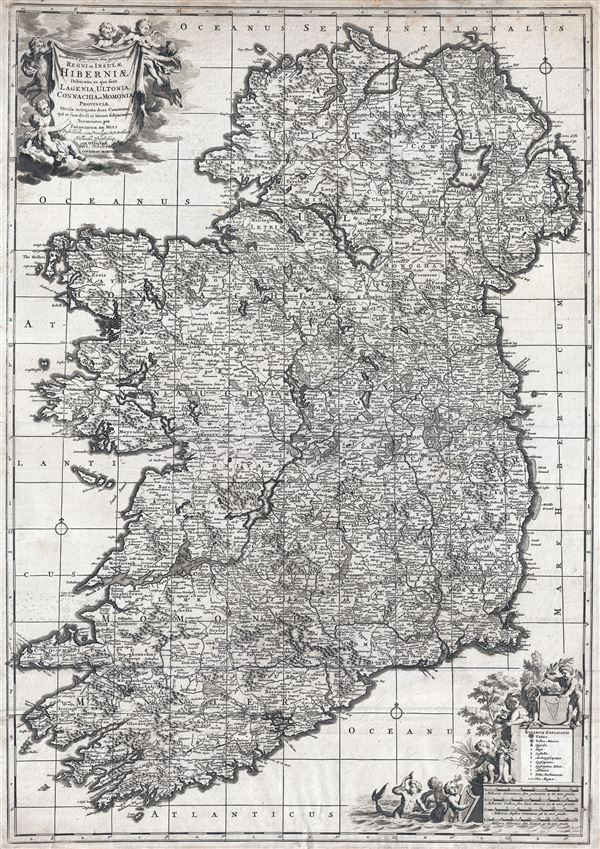
Novissima ac prae caeteris alus accuratissima Regni et Insulae Hiberniae delineatio in qua sunt Lagenia, Ultonia, Connachia et Momonia Provinciae divisae in triginta duos Comitatus qui et sunt divisi in omnes subjacentes Baronnatus.
1721 (undated) 28 x 19.5 in (71.12 x 49.53 cm) 1 : 710000
1721 (undated) 28 x 19.5 in (71.12 x 49.53 cm) 1 : 710000
Description
An uncommon large format map of Ireland by Frederik de Witt. This is the c. 1721 Covens and Mortier edition of a map originally issued in 1690. The map covers the entirety of insular Ireland in considerable detail. Counties, roadways, rivers, swamps, forests, and mountain rangers are noted. Topography is rendered in profile. The whole exhibits considerable accuracy giving ample evidence to Ireland's long cartographic history. Two decorative cartouches decorate the upper left and lower right quadrants. These feature the map's title, scale, and key. The primarily decorative cartouche-work includes various putti, mer-people, and an Irish Harp. Separate scales are offered in German, French, English, and Irish miles. That map, printed shortly following the 1721 Covens and Mortier acquisition of De Witt's plates from Maria De Witt, exhibits few substantive revisions over the 1690 edition beyond the title-area incorporation of the Covens and Mortier imprint.
CartographerS
Frederik de Wit (1629 - 1706) was a Dutch Golden Age cartographer active in the second half of the 17th and the early 18th centuries. De Wit was born of middle class Protestant stock in the western Netherlandish town of Gouda. He relocated to Amsterdam sometime before 1648, where he worked under Willem Blaeu. His first attributed engraved map, a plan of Haarlem for Antonius Sanderus' Flandria Illustrata, was issued around this time. He struck out on his own in 1654. The first chart that De Wit personally both drew and engraved was most likely his 1659 map of Denmark, REGNI DANIÆ Accuratissima delineatio Perfeckte Kaerte van ‘t CONJNCKRYCK DENEMARCKEN. His great wall map of the world and most famous work, Nova Totius Terrarum Orbis Tabula appeared one year later. Following the publication of his wall map De Wit quickly rose in prominence as a both cartographer and engraver. He married Maria van der Way in 1661 and through her became a citizen of Amsterdam in 1662. Around this time he also published his first major atlas, a composite production ranging in size from 17 to over 150 maps and charts. Other atlases and individual maps followed. In 1689 De Wit was granted a 15 year Privilege by the Dutch States General. (An early copyright that protected the recipient's rights to print and publish.) He was recognized with the honorific 'Good Citizen' in 1694. De Wit died in 1706 after which his wife Maria continued publishing his maps until about 1710. De Wit's son, Franciscus, had no interest in the map trade, instead choosing to prosper as a stockfish merchant. On her own retirement, Maria sold most De Wit maps and plates at a public auction. Most were acquired by Pieter Mortier and laid the groundwork for the 1721 rise of Covens and Mortier, the largest Dutch cartographic publishing house of the 18th century. More by this mapmaker...
Covens and Mortier (1721 - c. 1862) was an Amsterdam publishing firm, the successor to the extensive publishing empire built by Pierre Mortier (1661 - 1711). Covens and Mortier maps are often criticized as derivative - but this is not fully the case. Pierre Mortier lived in Paris from 1681 to 1685. There he established close relationships the the greatest French cartographers of the era, including De L'Isle and D'Anville. His business model was based upon leveraging Dutch printing technology and sophistication to co-publish state of the art French cartography. Upon Mortier's death in 1711 his firm was taken over by his son, Cornelius Mortier (1699 - 1783). Cornelius married the sister of Johannes Covens (1697 - 1774) in 1721 and, partnering with his brother in law, established the Covens and Mortier firm. Under the Covens and Mortier imprint, Cornelius and Johannes continued in Pierre's model of publishing the most up-to-date French works with permission. They quickly became one of the largest and most prolific Dutch publishing concerns of the 18th century. The firm and its successors published thousands of maps over a 120 year period from 1721 to the mid-1800s. During their long lifespan the Covens and Mortier firm published as Covens and Mortier (1721 - 1778), J. Covens and Son (1778 - 94) and Mortier, Covens and Son (1794 - c. 1862). Learn More...
Condition
Very good. Two sheets joined by publisher. Minor soiling. Minor verso repairs to margins.
References
Law, Bonar, The printed maps of Ireland : 1612-1850 DS 2