This item has been sold, but you can get on the Waitlist to be notified if another example becomes available.
1958 Gousha Map of Florida
HighwayMapFlorida-gousha-1958$137.50


Title
Highway Map of Florida.
1958 (dated) 26.75 x 18 in (67.945 x 45.72 cm) 1 : 1140480
1958 (dated) 26.75 x 18 in (67.945 x 45.72 cm) 1 : 1140480
Description
This is a 1958 H.M. Gousha Company highway map of Florida. Distributed by Cities Service (now CITGO), travelers and locals would both have benefited from its detail and clarity.
A Closer Look
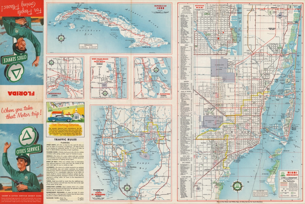
Depicting from Apalachicola National Forest to the Atlantic Ocean and from southern Georgia to Key West, Florida's road network appears in detail, with national, state, and local roads differentiated. Lakes and rivers are illustrated in blue, as are 'other roads', making the state appear at first glance to have many more rivers than it does. Distances between cities are provided. Historic sites, tourist destinations, and other places of interest are made prominent with red text. An index of counties and a partial list of cities and towns appears along the left border, while a key is situated in the upper right. An inset focusing on western Florida from the Alabama border to the Apalachicola National Forest appears in the lower left. A smaller inset, also in the lower left, details the region from Mobile to Pensacola.Verso Content
Six maps appear on the verso. The largest details Miami with an index of parks, airports, points of interest, yacht clubs, golf courses, and islands and keys. The other five focus on Tampa and St. Petersburg, St. Augustine, West Palm Beach and Palm Beach, Jacksonville, and the Republic of Cuba.Publication History and Census
This map was created and published by the H.M. Gousha Company in 1958 and distributed by Cities Service, an oil company now known as CITGO. Gousha published annual editions of their highway map of Florida, and it was distributed by several different companies, including Cities Service, Shell, and Billups. We have been unable to locate any other examples of the 1958 edition that was distributed by Cities Service, but an OCLC entry for the 1958 Gousha highway map of Florida exists (OCLC 953867707) but only directly references Shell Oil. It is likely that, due to cataloging inconsistencies, at least one of the 22 examples cataloged in OCLC is the same edition as the present map.Cartographer
Harry Mathais Gousha (May 16, 1892 – September 24, 1970) was an American map publisher. Gousha worked for Rand McNally in Chicago as a sales executive before founding the H.M. Gousha Company in 1926. Gousha's company quickly became a competitor with Rand McNally thanks to its Touraide, a spiral-bound book with road maps, points of interest, and accommodations that was custom assembled for each client. Gousha retired in 1942 but stayed on as a consultant. Gousha and the company's headquarters moved to San Jose, California in 1947. In 1961, the H.M. Gousha Company was acquired by the Times Mirror Company, and then by Simon and Schuster in 1987. What remained of Gousha was finally acquired by Rand McNally in 1996, and subsequently much of the company's archives were donated to the Newberry Library. More by this mapmaker...
Condition
Very good. Light wear along original fold lines. Some very slight loss at a few fold intersections. Light soiling. Text and maps on verso.