1858 Chace Wall Map of Hillsboro County, New Hampshire (Nashua, Manchester)
HillsboroCounty-chase-1858$1,500.00


Title
Map of Hillsboro Co. New Hampshire From Actual Surveys.
1858 (dated) 60 x 60 in (152.4 x 152.4 cm) 1 : 51000
1858 (dated) 60 x 60 in (152.4 x 152.4 cm) 1 : 51000
Description
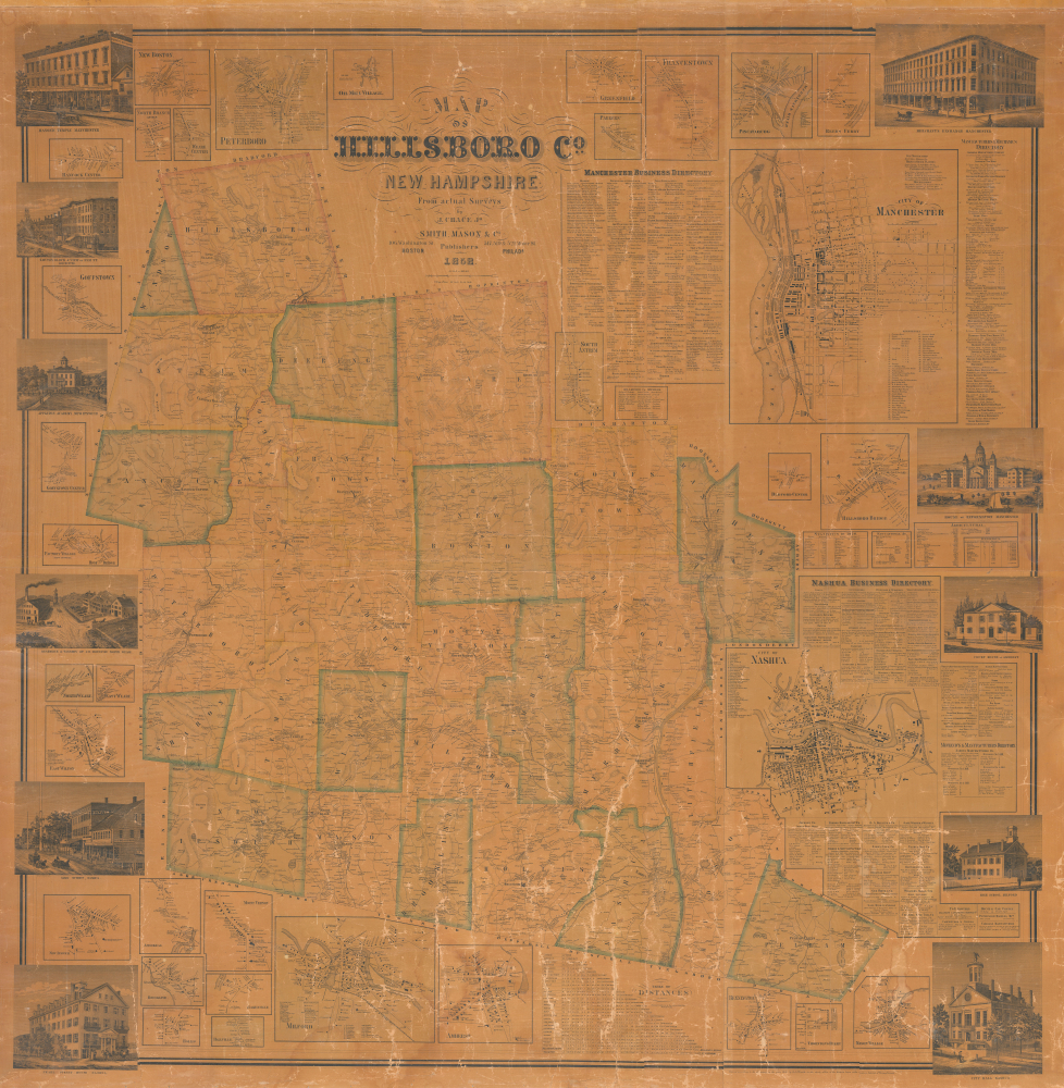
An uncommon 1858 Jacob Chace Jr. wall map of Hillsborough County (Hillsboro), New Hampshire, including large insets of Manchester and Nashua. The map captures the area, particularly the Merrimack River corridor, at the height of its prosperity as the center of textile production.
A Closer Look
This finely detailed map of Hillsborough County highlights the major commercial hubs of Manchester and Nashua along the Merrimack River. At its center, the main map depicts primary roads, topography, and landownership, while the margins feature 33 inset town plans that record streets, residences, businesses, and key landmarks. Surrounding these are 11 'Richardson Ambrotype' vignettes illustrating homes, institutions, commercial buildings, and street views, notable for their high level of detail and composition compared to typical examples of the period. Supplementing the visual content are business directories, statistical tables, and other reference data, making the piece both a geographic record and a valuable resource on the region's economic and social life.Publication History and Census
This map was surveyed by Jacob Chace and published by Smith, Mason, and Company. Both entities are elusive despite having produced a significant corpus. OCLC notes holdings of this map at the New York Public Library, Harvard, the Library of Congress, and the University of Southern Maine. It appears on the market from time to time.CartographerS
Jacob Chace Jr. (January 27, 1819 - February 18, 1903) was an American surveyor, civil engineer, educator, and map publisher. Born in North Hoosick, New York, Chace became one of the most prolific creators and publishers of county maps of the northeastern United States in the mid-19th century. He was involved in the production of large-format county maps, published mostly between 1854 and 1860. Many of these counties were in Maine, but he also produced maps of Vermont, New Hampshire, and New York. There is some ambiguity in historical accounts of his date of death. Many references state that he died in 1864 while Ambrose F. Church was working for him to create a map of Nova Scotia. However, references to a Jacob Chace surveying towns for maps of Virginia and North Carolina appear in newspaper columns in the 1870s and 1880s. Chace's name is sometimes misspelled on maps and references as 'Chase'. Our own research confirms that Chase died in Omaha, Nebraska, on February 18, 1903. More by this mapmaker...
Smith, Mason, and Company (fl. 1850 - 1865) was a map publishing firm with offices in several cities, including New York, Boston, Philadelphia, Troy, and Manchester, NH. They published numerous county wall maps, mostly focusing on New England, through the second half of the 19th century. The plethora of offices and addresses on their imprints suggests a large business, but the reality may be that most of these were little more than addresses and short-term annexes established to promote and sell individual maps. The firm was operated by Hoarce Mason, but due to the commonality of this name, we have had some difficulty narrowing his identity. Smith's like refers to 'H. and C.T. Smith', prominent map publishers in their own right. There are papers associated with Smith, Mason, and Company preserved at the Library of Congress, which remain undigitized but which may illuminate this firm. Learn More...
Condition
Average. Unrestored but stable, Overall varnish toning. Some cracking to paper, with very slight loss. As is. Priced accordingly.
References
Cobb, D., New Hampshire Maps to 1900: An Annotated Checklist, #3, #245. Phillips (America), p. 318. Boston Public Library, Leventhal Center, G3743.H4 1858.C5.