This item has been sold, but you can get on the Waitlist to be notified if another example becomes available, or purchase a digital scan.
1817 Arrowsmith / Hall Map of India, Nepal, Bhutan, Himalayas
Hindoostan-arrowsmith-1817$500.00

Title
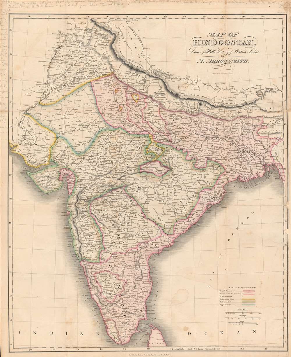
Map of Hindoostan drawn for Mill's History of British India.
1817 (dated) 25.5 x 20.75 in (64.77 x 52.705 cm) 1 : 5000000
1817 (dated) 25.5 x 20.75 in (64.77 x 52.705 cm) 1 : 5000000
Description
Here is a vivid 1817 map of India made by Aaron Arrowsmith and engraved by Sidney Hall for the first edition of James Mill's The History of British India. This map was made as the British East India Company (E.I.C.) was quickly acquiring territory in India, mostly at the expense of the Maratha Confederacy, and gaining allies (protectorates) among the smaller 'princely states.'
The stunning coloring used here distinguishes polities on the Indian subcontinent, which fell into three broad categories: the E.I.C. Presidencies (Madras, Bengal, Bombay), territories that were under the protection and indirect control of the E.I.C. (often dubbed 'princely states'), and territories independent of E.I.C. control, though the company lurked in the background of their domestic politics. The 'Rajpoot states' in blue here had friendly relations with the E.I.C. and entered a formal subsidiary alliance with it in 1818. The main rival of the E.I.C. at this time was the Maratha (Mahratta) Confederacy, outlined in green, mighty when united but internally divided in the early 19th century, which the E.I.C. was ready to exploit.
The same year this map was published, the Third Anglo-Maratha War broke out; when the war ended a year and a half later, the entirety of the lands of the Confederacy were under some form of British rule. At that point, the E.I.C. controlled nearly the entire subcontinent, save the Punjab, Sindh, and mountainous Himalayan regions, though even there they had gained territory in the recent Anglo-Nepalese War (1814 - 1816). In the following decades, the E.I.C. would push further north, setting them on a collision course with the growing Sikh Empire, which had recently relocated its capital from Lahore to Gujranwala (near Eminabad) when this map was published.
Arrowsmith had previously collaborated with the engraver Samuel Lewis in Philadelphia to produce a map of Hindoostan for their New and elegant General Atlas Comprising all Discoveries to the Present Time, the first edition of which was published in 1804. The same year that this map was published, Arrowsmith and Hall produced a smaller map of Hindoostan for the first edition of their A New General Atlas, Constructed from the Latest Authorities….
The present edition of the map is only independently cataloged in the holdings of the Bibliothèque nationale de France and the University of Edinburgh, and is scarce to the market, while the 1817 edition of Mill's book is held by a handful of universities and research institutions in North America, Europe, and across the former British Empire.
A Closer Look
This map shows the Indian subcontinent in considerable detail. Though not noted in the legend, settlements, roads, and rivers are indicated. Scales are given in miles, fursangs (parasangs, فرسنگ), and cosses (kos, कोस). Partly legible handwritten notes appear in the margin discussing different locations in India, while Ajmeer (Ajmer), near Jaypoor (Jaipur), is circled. This map, and Mill's book in which it appeared, reflect a growing familiarity with, or at least attention to, India in Britain.The stunning coloring used here distinguishes polities on the Indian subcontinent, which fell into three broad categories: the E.I.C. Presidencies (Madras, Bengal, Bombay), territories that were under the protection and indirect control of the E.I.C. (often dubbed 'princely states'), and territories independent of E.I.C. control, though the company lurked in the background of their domestic politics. The 'Rajpoot states' in blue here had friendly relations with the E.I.C. and entered a formal subsidiary alliance with it in 1818. The main rival of the E.I.C. at this time was the Maratha (Mahratta) Confederacy, outlined in green, mighty when united but internally divided in the early 19th century, which the E.I.C. was ready to exploit.
The same year this map was published, the Third Anglo-Maratha War broke out; when the war ended a year and a half later, the entirety of the lands of the Confederacy were under some form of British rule. At that point, the E.I.C. controlled nearly the entire subcontinent, save the Punjab, Sindh, and mountainous Himalayan regions, though even there they had gained territory in the recent Anglo-Nepalese War (1814 - 1816). In the following decades, the E.I.C. would push further north, setting them on a collision course with the growing Sikh Empire, which had recently relocated its capital from Lahore to Gujranwala (near Eminabad) when this map was published.
Publication History and Census
This map was drawn by Aaron Arrowsmith and engraved by Sidney Hall for James Mill's The History of British India, published by Baldwin, Cradock, and Joy in 1817, the first edition of Mill's book, a popular and influential work that had an enduring influence on (negative) British perceptions of India for decades. The map faced the title page of Volume III of Mill's work, as noted at top-right.Arrowsmith had previously collaborated with the engraver Samuel Lewis in Philadelphia to produce a map of Hindoostan for their New and elegant General Atlas Comprising all Discoveries to the Present Time, the first edition of which was published in 1804. The same year that this map was published, Arrowsmith and Hall produced a smaller map of Hindoostan for the first edition of their A New General Atlas, Constructed from the Latest Authorities….
The present edition of the map is only independently cataloged in the holdings of the Bibliothèque nationale de France and the University of Edinburgh, and is scarce to the market, while the 1817 edition of Mill's book is held by a handful of universities and research institutions in North America, Europe, and across the former British Empire.
CartographerS
Aaron Arrowsmith (1750-1823), John Arrowsmith (1790-1873), and Samuel Arrowsmith. The Arrowsmith family were noted map engravers, publishers, geographers, and cartographers active in the late 18th and early 19th century. The Arrowsmith firm was founded by Aaron Arrowsmith, who was trained in surveying and engraving under John Cary and William Faden. Arrowsmith founded the Arrowsmith firm as a side business while employed by Cary. The firm specialized in large format individual issue maps containing the most up to date and sophisticated information available. Arrowsmith's work drew the attention of the Prince of Wales who, in 1810, named him Hydrographer to the Prince of Wales, and subsequently, in 1820, Hydrographer to the King. Aaron Arrowsmith was succeeded by two sons, Aaron and Samuel, who followed him in the map publication business. The Arrowsmith firm eventually fell to John Arrowsmith (1790-1873), nephew of the elder Aaron. John was a founding member of the Royal Geographical Society. The firm is best known for their phenomenal large format mappings of North America. Mount Arrowsmith, situated east of Port Alberni on Vancouver Island, British Columbia, is named for Aaron Arrowsmith and his nephew John Arrowsmith. More by this mapmaker...
Sidney Hall (1788 - 1831) was an English engraver and map publisher active in London during the late 18th and early 19th centuries. His earliest imprints, dating to about 1814, suggest a partnership with Michael Thomson, another prominent English map engraver. Hall engraved for most of the prominent London map publishers of his day, including Aaron Arrowsmith, William Faden, William Harwood, and John Thomson, among others. Hall is credited as being one of the earliest adopters of steel plate engraving, a technique that allowed for finer detail and larger print runs due to the exceptional hardness of the medium. Upon his early death - he was only in his 40s - Hall's business was inherited by his wife, Selina Hall, who continued to publish under the imprint, "S. Hall", presumably for continuity. The business eventually passed to Sidney and Selina's nephew Edward Weller, who became extremely prominent in his own right. Learn More...
Baldwin and Cradock (fl. c. 1810 - 1860) were London based publishers working in the early to mid 19th century. They are best known for their publication of the Society for the Diffusion of Useful Knowledge's ground breaking subscription atlas. They also published John Thomson's magnificent New General Atlas from 1814 - c. 1820. In addition to their cartographic corpus, the firm had wide ranging publishing interests in many other areas, including books, broadsides, and an investment in Blackwoods Magazine. They had their offices at 47 Paternoster Row, London, England. This firm also published under the imprint Baldwin, Cradock, and Joy and Cradock and Joy. Learn More...
Source
Mill, J., The History of British India, Vol. III, (London: Baldwin, Cradock and Joy) 1817.
Condition
Good. Fold lines faint but visible. Damp staining at bottom-right. Wear in right-hand margin, especially at top-right.
References
OCLC 1113649017, 494680253.