
This item below is out of stock, but another example (left) is available. To view the available item, click "Details."
Details
1814 Thomson Map of India w/ Ganges
1814 (dated) $550.00
1817 Thomson Map of India w/ Ganges
Hindoostan2-thomson-1817$200.00

Title
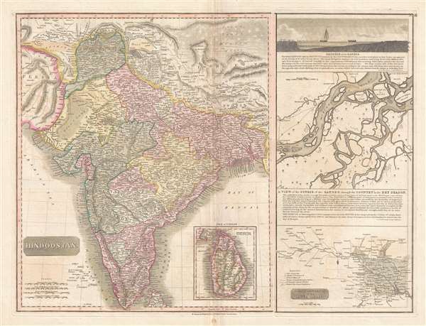
Hindoostan.
1817 (undated) 19 x 25 in (48.26 x 63.5 cm) 1 : 6900000
1817 (undated) 19 x 25 in (48.26 x 63.5 cm) 1 : 6900000
Description
This is the 1817 map of India with inset maps of the Ganges River by Edinburgh cartographer John Thomson. This magnificent map is the rarest of the Thomson India series. It depicts the whole of India from Lahore to the island of Ceylon (Shi Lanka). Numerous cities, towns, rivers, mountains and beautifully depicted deserts are noted throughout. The right-hand side of the map is dedicated to a careful mapping of the Ganges River and includes a cross-section of the Ganges, a map of the course of the Ganges in the dry season, and a map of the inland navigation routes along the river from the Bay of Bengal to Allahabad. This map's magnificent size, beautiful color, and high detail make this one of the finest atlas maps of this region to appear in the early 19th century.
As this map was being engraved and printed, India was in the midst of the Third Anglo-Maratha War (1817 – 1818) between the British East Indian Company (EIC) and the Maratha Empire. The war proved decisive with the EIC soundly defeating Maratha forces. The treaties ending the war consolidated British East Indian Company control over most of India south of the Sutlej River.
This map engraved by J. and G. Menzies and prepared by John Thomson for inclusion in the 1817 edition of Thomson's New General Atlas.
CartographerS
John Thomson (1777 - c. 1841) was a Scottish cartographer, publisher, and bookbinder active in Edinburgh during the early part of the 19th century. Thomson apprenticed under Edinburgh bookbinder Robert Alison. After his apprenticeship, he briefly went into business with Abraham Thomson. Later, the two parted ways, John Thomson segueing into maps and Abraham Thomson taking over the bookbinding portion of the business. Thomson is generally one of the leading publishers in the Edinburgh school of cartography, which flourished from roughly 1800 to 1830. Thomson and his contemporaries (Pinkerton and Cary) redefined European cartography by abandoning typical 18th-century decorative elements such as elaborate title cartouches and fantastic beasts in favor of detail and accuracy. Thomson's principle works include Thomson's New General Atlas, published from 1814 to 1821, the New Classical and Historical Atlas of 1829, and his 1830 Atlas of Scotland. The Atlas of Scotland, a work of groundbreaking detail and dedication, would eventually bankrupt the Thomson firm in 1830, at which time their plates were sequestered by the court. The firm partially recovered in the subsequent year, allowing Thomson to reclaim his printing plates in 1831, but filed again for bankruptcy in 1835, at which time most of his printing plates were sold to A. K. Johnston and Company. There is some suggestion that he continued to work as a bookbinder until 1841. Today, Thomson maps are becoming increasingly rare as they are highly admired for their impressive size, vivid hand coloration, and superb detail. More by this mapmaker...
John Menzies (October 27, 1772 - October 16, 1857) was a Scottish engraver active in Edinburgh during the late 18th and early 19th centuries. Menzies mastered engraving as an apprentice to James Rymer. In 1811, he partnered with his younger brother, George Menzies, to found the engraving firm of J. and G. Menzies, which was active until about 1831. Later his son, also named John, joined the firm and they engraved jointly under the imprint of J. Menzies and Son. At its height, the Menzies firm employed three men and three apprentices. Menzies engraved maps for Thomas Brown and John Thomson, among others. After his death, his son, John Menzies II (1819 – 1891), continued the family business until about 1891. Learn More...
Source
Thomson, J., A New General Atlas, (Edinburgh) 1817.
Thomson's New General Atlas was first published in 1817 and continued to be published until about 1821. This is the first of Thomson's major cartographic works and the atlas for which is most celebrated. The New General Atlas follows in the Edinburgh School, which eschews excessive decoration in favor of a more minimalistic fact-based cartographic vision, as established by John Pinkerton, Laurie and Whittle, John Cary, and others in the previous decades. The maps are notable for their massive scale, heavy stock, elegant color work, and easy-to-read typefaces. Although the atlas stopped being published after 1821, Thomson continued to offer 'supplementary' maps that could be tipped into the atlas as late as 1830, when he declared bankruptcy. The maps in the Thomson Atlas were engraved by Thomas Clerk, William Dassauville, Nathaniel Rogers Hewitt, James Kirkwood, Robert Kirkwood, John Menzies, George Menzies, Edward Mitchell, John Moffatt, Samuel John Neele, Robert Scott, and James Wyld.
Condition
Very good. Minor wear along original centerfold. Original platemark visible.
References
OCLC 43214273.