This item has been sold, but you can get on the Waitlist to be notified if another example becomes available, or purchase a digital scan.
1879 Stanford Map of the Hindu Kush Mountains (Pakistan, Afghanistan)
HinduKush-stanford-1879$187.50

Title
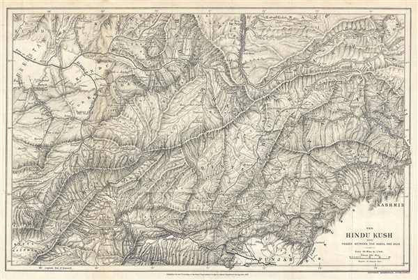
The Hindu Kush and Passes Between the Kabul and Oxus.
1879 (dated) 12 x 18 in (30.48 x 45.72 cm) 1 : 1520000
1879 (dated) 12 x 18 in (30.48 x 45.72 cm) 1 : 1520000
Description
This is a rare 1879 Sir Clements Robert Stanford map of Afghanistan and Pakistan. The map present parts of both Afghanistan and Pakistan, but is centered around the Hindu Kush Mountains and their watershed. The map depicts myriad rivers in the region, including the Kabul, Helmand, Indus, and Oxus, all of which flow out of the Hindu Kush. A range of high mountains, the Hindu Kush extend around 500 miles from the Pamir Mountains near the Pakistan-China border into western Afghanistan. The range forms the divide between the Amu Darya (Oxus) and the Indus river systems. Kabul, Jalalabad, and several other cities are depicted on the map. The map also labels the regions of Punjab and Kashmir, as well as the Pamir Plateau.
This map was published to accompany Sir Clements Robert's paper The Upper Basin of the Kabul River which appeared in the February 1879 edition of Proceedings of the Royal Geographical Society and Monthly Record of Geography. The map was published by the Stanford Geographical Establishment.
This map was published to accompany Sir Clements Robert's paper The Upper Basin of the Kabul River which appeared in the February 1879 edition of Proceedings of the Royal Geographical Society and Monthly Record of Geography. The map was published by the Stanford Geographical Establishment.
Cartographer
Edward Stanford (May 27, 1827 - November 3, 1904) was one of the most prolific map publishing firms of the late 19th century. The company began as a partnership in 1848 between the 21 year old Edward Stanford and the established map dealer Trelawney Saunders. By 1853 the partnership had dissolved and Edward Stanford took full control of the business. A subsequent series of expansions and exciting new map issues finally led to the production of Stanford's masterwork, "Stanford's Library Map of London". This map is still available and remains somewhat accurate. At the time of publishing it was hailed by the Royal Geographical Society as "the most perfect map of London that has ever been issued". In 1882 Edward Stanford Sr. passed the firm on to his son, Edward Stanford Jr. who continued in his father's proud tradition. Today the Stanford firm still publishes maps and remains one of the most important and prolific cartographic publishers in the world. More by this mapmaker...
Source
https://, C. R., 'The Upper Basin of the Kabul River', Proceedings of the Royal Geographical Society and Monthly Record of Geography, Vol. 1, No. 2, February 1879, Royal Geographical Society.
Condition
Very good. Blank on verso.
References
OCLC 66381505. Library of Congress G7632.H5 1879 .H5