1871 Petermann Map of the Hinlopen Strait, Svalbard, Norway
HinlopenStrait-petermann-1871$350.00

Title
Die Aufnahmen der I. Deutschen Nordpolar-Expedition in Nordost-Spitzbergen, August und September 1868.
1871 (dated) 10.25 x 8.5 in (26.035 x 21.59 cm) 1 : 400000
1871 (dated) 10.25 x 8.5 in (26.035 x 21.59 cm) 1 : 400000
Description
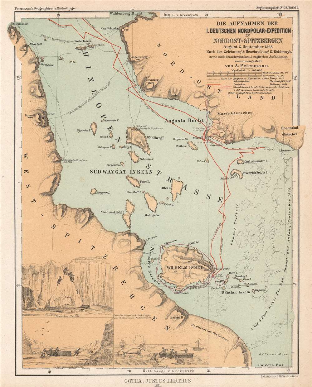
This is an 1871 Augustus Petermann map of Hinlopen Strait in the Svalbard Archipelago. Hinlopen Strait separates Spitsbergen and Nordaustlandet. The map highlights the route of the First German North Polar Expedition through the strait, which is often impassable due ice. Dates, anchorages, and shore excursions are noted, along with a handful of depth soundings. The 1827 English expedition led by Sir William Edward Parry (1790 - 1855) and the 1861 Swedish expedition led by Nils Otto Gustaf Nordenskjöld (1869 - 1928) are also traced. Three views appear in the lower left corner illustrate shore excursions, among them a walrus hunt.
The First German North Polar Expedition was not meant as a scientific expedition, simply an exploration. Their orders were to achieve the greatest possible latitude and not to embark on a thorough investigation of the region or a thorough mapping of the coastlines. Those activities would be undertaken by a subsequent expedition. After returning to Bergen on September 30, Koldeway believed that the expedition was 'an unfortunate, completely unsuccessful one'. However, the expedition achieved its goal of reaching an extremely high latitude and the scientific data they recorded, which included extensive oceanographic, meteorological, and geomagnetic readings, proved invaluable.
The First German North Polar Expedition
The First German North Polar Expedition was an arctic expedition led by Captain Carl Koldewey during the summer of 1868. Inspired by the great German geographer Augustus Heinrich Petermann (1822 - 1878), the expedition left Bergen on May 24, 1868. Given the primary objective of reaching Greenland's east coast, the ship and her crew reached sea ice on June 4 and were stuck by June 9. They spent the next two weeks drifting with the current before they were able to break free of the ice and get underway again. Once free, Koldewey continued with the expedition's secondary objective: reaching 'Gillis-Land' an island northeast of Svalbard, since it was apparent that reaching Greenland's east coast by sea was not possible. The expedition proceeded along the sea ice to Svalbard. but were stymied in their attempt to round the archipelago on the south. They reversed course, electing to try to reach Greenland again, but were again unsuccessful. Heading north one last time, the expedition tried to get past Svalbard to the north, and, in doing so, spent weeks exploring the Hinlopen Strait. The Expedition also reached 81 degrees, 4 minutes north latitude on September 13, still a record for the highest northern latitude reached by a sailing ship without auxiliary drive.The First German North Polar Expedition was not meant as a scientific expedition, simply an exploration. Their orders were to achieve the greatest possible latitude and not to embark on a thorough investigation of the region or a thorough mapping of the coastlines. Those activities would be undertaken by a subsequent expedition. After returning to Bergen on September 30, Koldeway believed that the expedition was 'an unfortunate, completely unsuccessful one'. However, the expedition achieved its goal of reaching an extremely high latitude and the scientific data they recorded, which included extensive oceanographic, meteorological, and geomagnetic readings, proved invaluable.
Svalbard
Dutch explorer Willem Barentz (1557 - 1597) first discovered Svalbard in 1596, and the first recorded landing on the island happened in 1604. During the early 17th century, whalers established the first settlements in the archipelago, and by the early 1630s, the heartiest would winter on the islands. Russian hunters arrived in the late 17th century and set up relatively permanent settlements. Nonetheless, by the 1860s the islands were again largely uninhabited. Svalbard became a destination for Arctic tourism in the 1890s. Today, Svalbard's three principal industries are mining, tourism, and research. It is also home to the Svalbard Global Seed Vault.Publication History and Census
This map was created by Augustus Petermann and published in 1871 by Justus Perthes for Die Erste Deutsche Nordpolar-Expedition im Jahre 1868. The book is well represented in institutional collections. Two examples of the separate map are cataloged in OCLC as part of the institutional collections at the British Library and the Bayerische Staatsbibliothek.CartographerS
August Heinrich Petermann (1822 - 1878) was a German cartographer. Petermann attended the 'Geographische Kuntschule' (Geographica School of Art), which was started by Heinrich Berghaus with the support of Alexander von Humboldt, in Potsdam beginning in 1839. Students at the school were obliged to work on many of the school's contracts, including maps for several different atlases. Following his time in Potsdam, Petermann relocated to Edinburgh and London from 1845 to 1854, where he gained insight into the commercial aspects of the cartography business. In 1854, Petermann returned to Gotha, Germany and began working with the Perthes brothers publishers. While working with the Perthes brothers, Petermann founded the journal Petermanns Geographische Mitteilungen, published from 1855 until 2014, long one of the most prominent German-language geography journals. More by this mapmaker...
Johan Georg Justus Perthes (September 11, 1749 - May 2, 1816) was one of the most important German cartographic engravers of the 19th century. He was born in the Thuringian town of Rudolstadt, the son of a court physician. In 1778, he began working as a bookseller in Gotha. Perthes began his publishing empire shortly thereafter with the 1784 issue of the famed survey of European nobility known as the Almanac de Gotha. In the next year, 1785, he founded the cartographic firm of Justus Perthes Geographische Anstalt Gotha. His son Wilhelm Perthes (1793 - 1853) joined the firm in 1814. Wilhelm had prior publishing experience at the firm of Justus Perthes' nephew, Friedrich Christoph Perthes, who ran a publishing house in Hamburg. After Justus Perthes died in 1816, Wilhelm took charge and laid the groundwork for the firm to become a cartographic publishing titan. From 1817 to 1890. the Perthes firm issued thousands of maps and more than 20 different atlases. Along with the visionary editors Hermann Berghaus (1797 - 1884), Adolph Stieler (1775 - 1836), and Karl Spruner (1803 - 1892), the Perthes firm pioneered the Hand Atlas. When Wilhelm retired, management of the firm passed to his son, Bernhardt Wilhelm Perthes (1821 – 1857). Bernhardt brought on the cartographic geniuses August Heinrich Peterman (1822 - 1878) and Bruno Hassenstein (1839 - 1902). The firm was subsequently passed to a fourth generation in the form of Berhanrd Perthes (1858 – 1919), Bernhard Wilhelm's son. The firm continued in the family until 1953 when, being in East Germany, it was nationalized and run as a state-owned enterprise as VEB Hermann Haack Geographisch-Kartographische Anstalt Gotha. The Justus family, led by Joachim Justus Perthes and his son Wolf-Jürgen Perthes, relocated to Darmstadt where they founded the Justus Perthes Geographische Verlagsanstalt Darmstadt. Learn More...
Source
Koldewey, K. Die Erste Deutsche Nordpolar-Expedition im Jahre 1868, (Perthes: Gotha) 1871.
Condition
Very good. Extremely minor closed margin tear professionally repaired on verso.
References
OCLC 557543968.