1949 Ralph Shane Pictorial Map of Warm Springs Indian Reservation, Oregon
HistoricalMapWarmSprings-shane-1949$200.00

Title
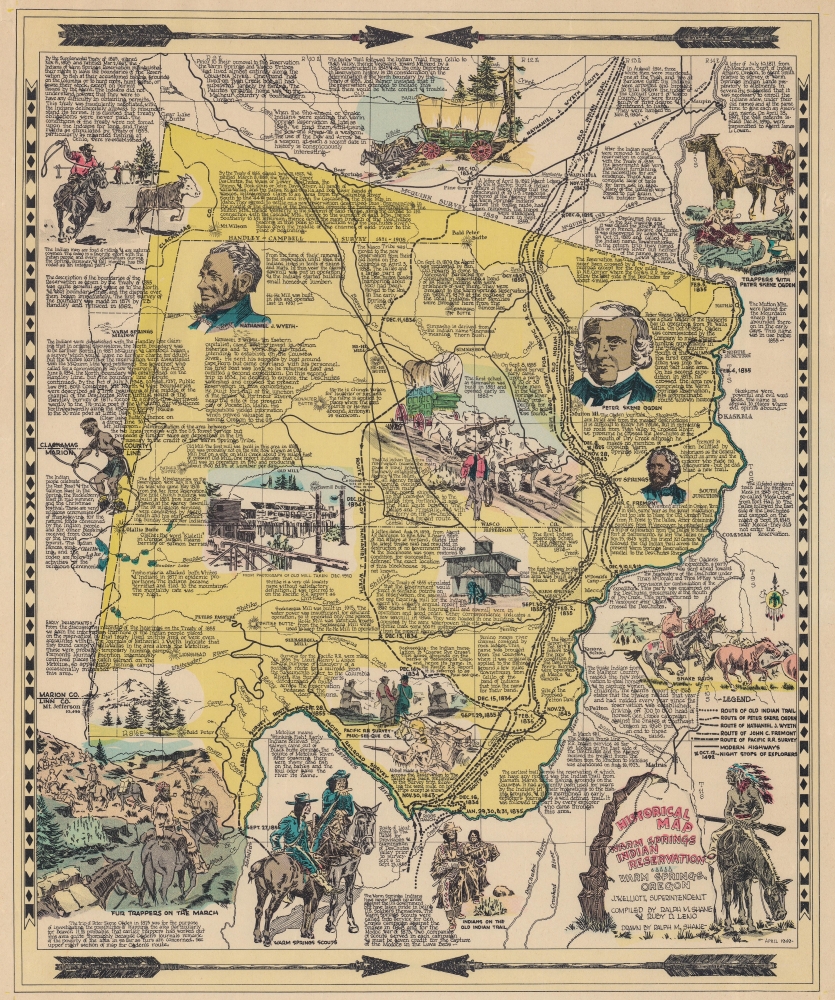
Historical Map Warm Springs Indian Reservation.
1949 (dated) 18 x 15 in (45.72 x 38.1 cm)
1949 (dated) 18 x 15 in (45.72 x 38.1 cm)
Description
This is the 1949 first edition of Ralph M. Shane pictorial map of the Warm Springs Indian Reservation, Oregon. Shane, who worked for the Bureau of Indian Affairs, delivers a detailed graphic history of the reservation and region.
A Closer Look
Coverage embraces the reservation in full. Contrasting shades of yellow illustrate the border dispute between the Warm Springs people, the U.S. government, and settlers (these lands were restored to the Warm Springs people in 1972). Vignettes capture historic sites and moments, such as trappers exploring the region with Peter Skene Ogden. Illustrations of Native American raiders, modern Native Americans participating in a rodeo, and the mills built by the U.S. government as part of the treaty agreement appear as well. Informative captions fill the sheet with local and reservation history.Publication History and Census
This map was drawn by Ralph M. Shane and first published as here in 1949. A second edition was published by the Oregon Historical Society in 1974. Both editions are cataloged in the same OCLC entry, and of the nearly two dozen examples cataloged, only two appear to be examples of the 1949 edition. These are part of the collections at Minnesota State University Mankato and the University of California Santa Barbara.Cartographer
Ralph M. Shane (1910 - July 12, 1984) was an artist and U.S. government engineer. Born near Edelstein, Illinois, Shane's parents moved the family to Pipestone, Minnesota, where he attended public school. After high school, Shane attended the University of Colorado before transferring to the South Dakota School of Mines, where he graduated in 1935 with a B.S. in engineering. He found work with the South Dakota State Highway Commission and drafted strip and right-of-way maps. In November 1936, Shane joined the Bureau of Indian Affairs as an engineering draftsman. He was promoted to junior road engineer the following year. The Bureau transferred him to Sacramento, California, in January 1939 to work as chief of a road survey party. Shane worked as a road engineer for the Bureau of Indian Affairs across the western United States through the 1940s and 1950s, except for a four-month furlough in 1943 when he served as a Navy ensign. He left the Bureau of Indian Affairs in 1955 and bought a newspaper in New Town, North Dakota, which he edited for two years before returning to the Bureau of Indian Affairs. He retired from the Bureau in 1979. Shane was married twice. First to Jeanette Wildman, whom he married in 1936, then to Carolyn Mae Hodgkinson, whom he married on July 14, 1944. He had four children. More by this mapmaker...
Condition
Very good. Closed margin tears professionally repaired on verso.
References
OCLC 9152019.