1823 Franz Pluth Comparative Chart of the World's Mountains
HohenCharte-pluth-1823$500.00

Title
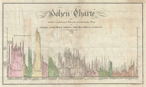
Höhen Charte oder bildlich vergleichende Übersicht der bedeutendsten Berge in Europa Asien, Africa, America und den Südsee Ländern.
1823 (dated) 12 x 20 in (30.48 x 50.8 cm)
1823 (dated) 12 x 20 in (30.48 x 50.8 cm)
Description
This is an unusual 1823 comparative mountains chart prepared by the Czech engraver Franz Pluth. The chart juxtaposes in close proximity the mountains of Europe, Asia, Africa, America, and Australia. This unusual style of comparative chart, wherein the mountains resemble inverted icicles, was current in Germany in the early part of the 18th century. It is derived from a chart issued by Karl Ferdinand Weiland in Weimar, Germany, c. 1820. The style itself is based upon that of French scientist M. Pasumont, who published a similar comparative chart in the September 1783 journal de Physique. While not as visually arresting as the more pictorial comparative charts then appearing in France and England, it had technical advantages, including allowing the chart maker to incorporate more mountains in an easy to understand graph-like format. The highest mountain here identified is Dhaulagiri, incorrectly assessed at 24,831 feet (actual height 26,795). The height of nearby Everest had not then been ascertained.
Pluth prepared this map to illustrate F. L. Linder's Neueste Länder. Linder's book is typically dated 1820, but contains maps dated between 1816 and 1825.
Pluth prepared this map to illustrate F. L. Linder's Neueste Länder. Linder's book is typically dated 1820, but contains maps dated between 1816 and 1825.
Cartographer
Franz Pluth (1800 - 1871) was an engraver based in Prague, the capital of the Kingdom of Bohemia, then part of the Habsburg Austrian Empire. Pluth was born in Prague and most likely died in Zbraslav. He was active as a map engraver until at least 1848. His work is similar in style to that of Karl Ferdinand Weiland, a prolific German engraver, with whom he may have worked. More by this mapmaker...
Source
Linder, F. L., Neueste Länder - und Völkerkunde, ein geographisches Lesebuch für alle Stände. , (Prague) 1820.
Condition
Very good. Light toning.
References
OCLC 174194291, 868145509. Wolter, John, A., 'The Heights of Mountains and Lengths of Rivers', The Quarterly Journal of the Library of Congress, July 1972, page 192.