
This item below is out of stock, but another example (left) is available. To view the available item, click "Details."
Details
1854 Fujita Map of Hokkaido, Sakhalin, and the Kuril Islands
$2,750.00
1854 Kaei 7 Fijita Map of Hokkaido, Sakhalin, and the Kuril Islands
Hokkaido-fujita-1854$925.00

Title
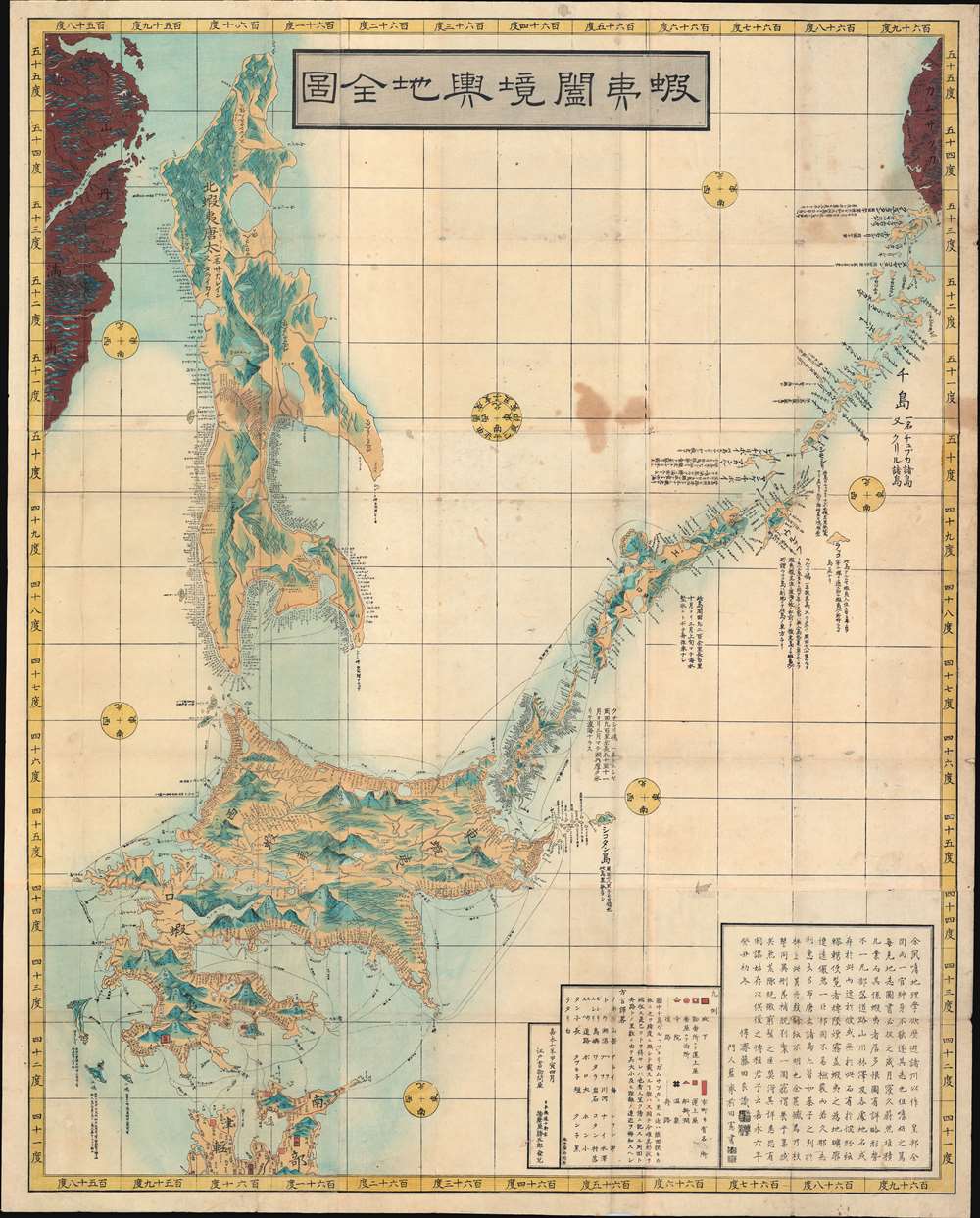
蝦夷闔境輿地全図 / Ezo Kokyou Yochi Zenzu. / Complete Map Ezo Border.
1854 (dated) 47.25 x 38.5 in (120.015 x 97.79 cm)
1854 (dated) 47.25 x 38.5 in (120.015 x 97.79 cm)
Description
This is a rare 1854, Kaei 7, Japanese Edo period Fujita Ryou (橋本貞秀) chromoxylographic map illustrating Hokkaido, Sakhalin, and the Japanese Kuril Islands. It was issued following the 1853 arrival of Commodore Matthew Perry anticipating the opening of Hakodate as one of the 5 Japanese treaty ports. The maps coverage extends north from the tip of Honshu to include Sakhalin Island and the Kuril Islands as far as Kamchatka. This is a practical map, intended for actual Japanese voyages, both military and trade, and thus features copious annotations and coastal notes. A preface in Chinese is added to the end of the map, and 16 Ainu words are listed as 'dialect translation abbreviations'.
Historical Context
This map was issued following Commodore Perry's 1853 arrival that forced the Shogun to open Japan to foreign Trade. On his second visit to Japan, he did a more thorough reconnaissance, visiting Hokkaido and the city of Hakodate. In 1854, under the Convention of Kanagawa, as negotiated by Commodore Matthew Perry, Hakodate port partially opened to foreign ships for provisioning. Several years later, on June 2, 1859, Hakodate fully opened as one of five Japanese ports designated as free-trade zones by the 1858 Treaty of Amity and Commerce. A foreign zone, the U.S. Hakodate Foreign Settlement, quickly established and remains one of the legacies of the treaty.Russian Border Questions
Fearing further loss of sovereignty, the Shogunate reinstituted the Hakodate Bugyō, or governorship, under the old Samurai system. At the same time, the arrival of foreigners led the Shogunate to order a reassessment of known border cartography, resulting in a wealth of new maps covering the extremes of the empire - of which this, embracing the very fringes of Tokugawa Era geographical knowledge, is one of the most important. Americans were not the only foreigners interested in Hokkaido (Ezo, as it was then known). Long neglected by the Shogunate, the indigenous Ainu frequently traveled north to Sakhalin or Kamchatka to pay tribute to Manchu and Russian powers. Part of this map's purpose was to facilitate the formalization of borders with the Russians.Publication History and Census
This map was first printed in Kaei 6, or 1853. The map was compiled by Fujita Ryou (藤田良) and drawn by the Japanese mapmakers and Ukiyo-e printer Sadahide Hashimoto (橋本貞秀). Fujita Ryou, the compiler, is elusive and even within Japan, nothing is known. The present example is the second edition, issued in Kaei 7, 1854. It was published by Katsugoro Harimaya, a book wholesaler at the Edo Nihonbashi Dori Juken store. The map is present in several institutional collections in Japan, and at the Staatsbibliothek zu Berlin, but is otherwise scarce, with no market presence.CartographerS
Fujita Ryou (藤田良; fl. 1850 - 1959), also known as 'Kousai' was a Japanese cartographer of the late Edo Period. He produced a large map of Hokkaido in 1854. He is otherwise elusive. More by this mapmaker...
Sadahide Hashimoto (橋本貞秀; ハシモト, サダヒデ; 1807 - 1878), also known as Gountei Sadahide (五雲亭貞秀) and Hashimoto Gyokuran (橋本玉蘭), was a Japanese artist active in Yokohama in the second half of the 19th century. He was born in Chiba Prefecture. Hashimoto is best known for his renderings of foreigners, in particular Western peoples and customs, as observed while living in the open port of Yokohama. He is considered to be a disciple of Takako Kunisada, another artist of the Toyokuni Utagawa school, earning him the name Utagawa Sadahide (歌川貞秀). Hashimoto met Kunisada in 1826, when he was 14 years old and most of his early work reflects the work of Kunisada. Even before the Bankumatsu period, Sadahide took an interest in distant and foreign lands, publishing an important and controversial account of the First Opium War between Britain and Qing China (Kaigai Shinwa, 海外新話) with the scholar Mineta Fūkō (嶺田楓江). Following the 'opening of Japan' in 1853, he produced a series of prints of Ainu people in Kita Ezo zusetsu (北蝦夷図説) as well as a world map that was likely based on a Dutch original (https://www.geographicus.com/P/AntiqueMap/world-mineta-1853), also with Mineta. He developed an interest in geography and began issuing maps and bird's-eye views, some quite large over multiple panels, of Japanese cities. At the very end of the Tokugawa period, he moved to Nagasaki and was selected as part of a Japanese delegation to the International Exposition of 1867. Sadahide died about a decade later, living long enough to see the rapid transofrmation of Japan following the Meiji Restoration. He was a mentor to Hideki Utagawa. Learn More...
Katsugoro Harimaya (播磨屋勝五郎; fl. c. 1850 - 1865) was a Japanese publisher and bookseller at the Edo Nihonbashi Dori Juken store. Harimaya is known for publishing many books related to Ezo at the end of the Tokugawa shogunate. Learn More...
Condition
Good. Some older Japanese repairs to wormholes on verso. Wear on old fold lines. Some spotting.
References
Staatsbibliothek zu Berlin, 3343782181. OCLC 1146712142.