This item has been sold, but you can get on the Waitlist to be notified if another example becomes available, or purchase a digital scan.
1633 Hondius Map of the Holy Land, Israel, or Palestine
HolyLand-hondius-1633$600.00

Title
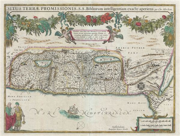
Situs Terrae Promissionis. S.S. Bibliorum intelligentiam exact aperiens
1633 (undated) 13.5 x 20.5 in (34.29 x 52.07 cm)
1633 (undated) 13.5 x 20.5 in (34.29 x 52.07 cm)
Description
A fine 1633 old color example of Christian van Adrichom's map of the Holy Land, Israel, or Palestine drawn, published by Jodocus Hondius. Oriented to the east, this map covers the whole of the Holy Land on both sides of the Jordan River from the desert of Moab to the Mediterranean and from modern day Lebanon to egypt's Nile Delta. The map is divided according to the Twelve Tribes of Israel while the portions of the map to the south of the Dead Sea show the Wandering of the Israelites in the Desert – a forty year episode from exodus. Throughout tiny vignettes illustrate episodes from Biblical lore ranging from the encampment of the Israelites in the desert to the parting of the Red Sea to the lost Dead Sea cities of Sodom, Gomorra, Schoim, and Adama. Fishing boats populate the Sea of Galilee and major roadways and other trade routes are noted included. The upper portions of the map are decorated with putti and an elaborate floral garland hanging suspended from the title. In the lower left quadrant Moses and Aaron discuss the tablets of the Law. Two distance scales contained within a strapwork border appear in the lower right. A further vignette, bottom center, illustrates Jonah and the Whale. This map was issued by Gerard Mercator and Jodocus Hondius in the third volume of their influential atlas, Le Nouveau Theatre du Monde, published in 1639. Later examples appeared in several other atlases and were also taken up by other cartographers, most notably Jan Janssonius in 1653.
CartographerS
Jodocus Hondius (October, 14 1563 - February 12, 1612) was an important Dutch cartographer active in the late 16th and early 17th centuries. His common name, Jodocus Hondius is actually a Latinized version of his Dutch name, Joost de Hondt. He is also sometimes referred to as Jodocus Hondius the Elder to distinguish him from his sons. Hondius was a Flemish artist, engraver, and cartographer. He is best known for his early maps of the New World and Europe, for re-establishing the reputation of the work of Gerard Mercator, and for his portraits of Francis Drake. Hondius was born and raised in Ghent. In his early years he established himself as an engraver, instrument maker and globe maker. In 1584 he moved to London to escape religious difficulties in Flanders. During his stay in England, Hondius was instrumental in publicizing the work of Francis Drake, who had made a circumnavigation of the world in the late 1570s. In particular, in 1589 Hondius produced a now famous map of the cove of New Albion, where Drake briefly established a settlement on the west coast of North America. Hondius' map was based on journal and eyewitness accounts of the trip and has long fueled speculation about the precise location of Drake's landing, which has not yet been firmly established by historians. Hondius is also thought to be the artist of several well-known portraits of Drake that are now in the National Portrait Gallery in London. In 1593, Hondius returned to Amsterdam, where he remained until the end of his life. In 1604, he purchased the plates of Gerard Mercator's Atlas from Mercator's grandson. Mercator's work had languished in comparison to the rival atlas, Theatrum Orbis Terrarum by Ortelius. Hondius republished Mercator's work with 36 additional maps, including several which he himself produced. Despite the addition of his own contributions, Hondius recognizing the prestige of Mercator's name, gave Mercator full credit as the author of the work, listing himself as the publisher. Hondius' new edition of Mercator revived the great cartographer's reputation and was a great success, selling out after a year. Hondius later published a second edition, as well as a pocket version called the Atlas Minor. The maps have since become known as the "Mercator/Hondius series". Between 1605 and 1610 Hondius was employed by John Speed to engrave the plates for Speed's The Theatre of the Empire of Great Britaine. Following Hondius' death in 1612, his publishing work in Amsterdam was continued by his widow and two sons, Jodocus II and Henricus. Later his family formed a partnership with Jan Jansson, whose name appears on the Atlasas co-publisher after 1633. Eventually, starting with the first 1606 edition in Latin, about 50 editions of the Atlas were released in the main European languages. In the Islamic world, the atlas was partially translated by the Turkish scholar Katip Çelebi. The series is sometimes called the 'Mercator/Hondius/Jansson' series because of Jansson's later contributions. Hondius' is also credited with a number of important cartographic innovations including the introduction of decorative map borders and contributions to the evolution of 17th century Dutch wall maps. The work of Hondius was essential to the establishment Amsterdam as the center of cartography in Europe in the 17th century. More by this mapmaker...
Christian Kruik van Adrichem (February 13, 1533 - June 20, 1585), alternatively known as Christianus Crucius Adrichomius was a Dutch theologian active in the second half of the 16th century. Adrichem was born in Delft of a wealthy family - at one point his father, Adriaen Claesz, was mayor of Delft. Adrichem was ordained in 1566. He served as the director of the Convent of St. Barbara in Delft until expelled by the Protestant Reformation. Fleeing the anti-Catholic sentiment of the Reformation, Adrichem reestablished himself in Cologne (Koln) where compiled various religious works including his important historical atlas, the Theatrum Terrae Sanctae et Biblicarum Historiarum. Adrichem's important atlas was published posthumously by his associate Gerardis Brunius in 1590. The work went through numerous editions and served as the foundation of most subsequent maps of the Holy Land well into the 18th century. Learn More...
Source
Mercator, G. and Hondius, J., Le Nouveau Theatre du Monde, (Amsterdam, French edition) 1636.
Condition
Very good. Original centerfold. French text on verso. Original platemark visible. Wide clean margins.
References
Laor, E., Maps of the Holy Land: Cartobibliography of Printed Maps, 1475 - 1900, #23C.