
1937 Japanese Military Map of Hong Kong (anticipiating 1941 Invasion)

This item has been sold.
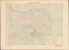
香港近傍圖 / Hong Kong and the New Territories.
Anticipating Black Christmas.
- Digital Map Information
- Suitable for large format printing
- Full resolution TIFF file
- ICC color profile embedded
- Delivered instantly via download link
Anticipating Black Christmas.
This is a December 1937 Imperial Japanese Army map of Hong Kong and the New Territories, marked 'secret' (秘) and published four years before the 1941 Japanese takeover of Hong Kong. Prepared by the Imperial Army's Land Survey Department and issued by the General Staff Headquarters, it records the colony and its mainland approaches during the opening year of the Second Sino-Japanese War (1937 - 1945). Its significance is the conjunction of detailed military geography and timing: Japan occupied nearby Guangzhou the following October, bringing Japanese forces into threatening proximity to the frontier mapped here. There can be little doubt that this map presages Black Christmas.A Closer Look
The map encompasses Hong Kong Island, Kowloon, the New Territories, Lantau, Lamma, and surrounding islands, extending north into Chinese territory beyond the colonial boundary. Deep Bay, here also identified as Shenzhen Bay, anchors the western side of the mainland frontier, while Mirs Bay dominates the northeast. The northern boundary and its relationship to settlements, roads, waterways, and mountain passes place the colony within its surrounding geography rather than treating Hong Kong as an isolated port.Fine brown contours distinguish the mountainous interior from the more accessible valleys and coastal plains. Dense settlement and street detail around Victoria Harbour contrasts with the dispersed villages, cultivated land, and tracks of the New Territories. The Kowloon-Canton Railway provides a conspicuous connection between the urban waterfront and the mainland frontier. Blue hydrography and coastal detail complement the land information, while a purple rectangular grid and circular angular diagrams provide additional tools for plotting positions and directions.
The English title, extensive romanized place-names, and bilingual reference table coexist with Japanese marginal instructions and publication information. The legend distinguishes roads and paths of different qualities, railways, communications lines, buildings, vegetation, and coastal features. Particularly revealing is the warning that roads in Chinese territory may be inaccurate. This qualification identifies a practical limit to the map's intelligence: knowledge of routes beyond the British boundary could not be assumed to match the apparent precision of the printed sheet. The character 秘, meaning secret, appears prominently in the upper-left margin.
Before Black Christmas
The map was published only months after the July 1937 outbreak of full-scale war between China and Japan. Japan's capture of Guangzhou in October 1938 began three years of increasingly uneasy peace for Hong Kong, leaving the British colony exposed to Japanese military power on the neighboring mainland. Refugees poured into the territory, bringing the consequences of the war in China into its streets and placing severe pressure on housing and relief services. Britain sought to avoid open conflict with Imperial Japan while strengthening the colony's defenses, but the outbreak of war in Europe in September 1939 further constrained its ability to protect this distant imperial outpost. Japanese officers, meanwhile, developed detailed invasion plans by the end of 1939. Military and civilian defense preparations, followed by the arrival of Canadian reinforcements in November 1941, gave increasingly concrete expression to the apprehension that Hong Kong might become the next battlefield.Hong Kong remained under British administration during this period, but its connections to the Chinese mainland made it important to the movement of military supplies. Japan's occupation of Guangzhou on October 21, 1938, severed the Kowloon-Canton Railway connection and directly threatened the colony's security. Thus, the frontier and transport routes represented here acquired an immediate strategic relevance well before the invasion of Hong Kong itself. On December 8, 1941, Japanese aircraft attacked Hong Kong while ground forces crossed the frontier from China into the New Territories. After the mainland defenses were overcome, Japanese troops crossed to Hong Kong Island on December 18. The fighting ended with the colony's surrender on December 25, remembered as Black Christmas. This sheet documents the military mapping that preceded that 18-day campaign.
Publication History
The map was prepared for printing in December 1937 (Showa 12) and published in Tokyo by the Imperial Japanese Army General Staff Headquarters, jointly with the Land Survey Department. This regional sheet was part of a broader Japanese military mapping effort focused on Hong Kong. Related publications included a more detailed Hong Kong vicinity series beginning in 1937 and maps of defensive installations issued in August 1939. Of this specific map, we know of only one other surviving example, located in the archives of Japan's National Diet Library.Cartographers
Imperial Japanese Army General Staff Office (大日本帝國陸軍参謀本部, initially as 參謀局; 1872 - 1945) was tasked with Imperial Japan's strategic planning and command functions, enjoying direct access to the emperor and freedom from oversight by the civilian government. While the War Ministry handled tasks like mobilization and logistics, the General Staff managed war plans, military intelligence, and cartography (through the Land Survey Bureau 陸地測量部). At the end of the Second World War, one of the U.S. occupation authorities' early tasks was to dissolve the General Staff as part of a broader demilitarization of Japan. Further Details...
Japanese Imperial Land Survey (陸地測量部; 1888 - present) is a Japanese governmental mapping agency established in 1888 to map the home islands. By 1925, the Land Survey had completed a 1:50,000-scale map of the home islands. Then expansionist, the Imperial Japanese were keenly aware that, like railroads, telegraphs, and guns, maps were tools of empire indispensable to governance, surveillance, commerce, and countless other imperial initiatives, the very lifeblood of the state. As Japan expanded into Korea, Taiwan, the Philippines, and elsewhere, imperial cartographers followed closely behind imperial soldiers. Their work was of the highest caliber and incorporated the most modern and sophisticated survey techniques, resulting in maps that exceeded all previous work in their respective regions in both thoroughness and accuracy. After World War II, the Japanese Imperial Land Survey was folded into the civil administration, but it still functions as part of the Japanese government. Further Details...
Condition
Very good. Slight waterstains, lower right.
References
National Diet Library, YG821-2787. OCLC 675985206.