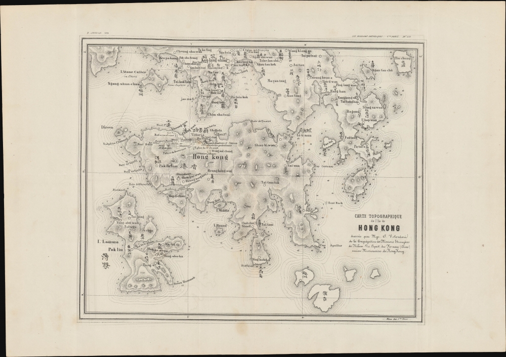
1874 Volonteri Bi-Lingual Map of Hong Kong
HongKong-volonteri-1874$4,000.00

Title
Carte Topographique de l'ile de Hong Kong dressee par Mgr. S. Volonteri de la Congregation des Missions Etrangeres de Milan Vic. Apoost du Ho-non (Chine) ancien Missionaire de Hong-Kong.
1874 (undated) 9.5 x 12 in (24.13 x 30.48 cm)
1874 (undated) 9.5 x 12 in (24.13 x 30.48 cm)
Description
This is Simeone Volonteri's 1874 map of Hong Kong, the first map to offer detailed bi-lingual content specifically of Hong Kong. It is the second and lesser known of Volonteri's two maps, the first being his unobtainable 1866 Map of the San-On District (Guangdong Province). Although derived from the 1866 map, the present publication offers a significantly updated specific look at Hong Kong, with many more place names, among them the 'Eglise de S. Francois' and the 'Prison Anglais' (west of Kowloon). It served as the primary geographical reference for Hong Kong until the official surveys of 1901.
Volonteri's Illegal Mapping of Hong Kong
Volonteri's two maps of Hong Kong are both based on his own hands-on surveys conducted from 1861 - 1865. From his mission in Sai Kung he ranged broadly around Hong Kong, taking meticulous notes and topographical measurements. This work, at the time, was illegal, as Jesuit mapmaking was forbidden without the explicit approval of the Qing. Had he been caught, it would have been considered espionage, punishable by death. The Government Gazette (May 26, 1866), describes the difficulties in surveying the region,The Map is the result of four years' labour and is made entirely from the personal observations of the author. The dangers, the difficulties, and the hardships which the work has involved have been very great. The District is excessively mountainous, and, as ocular demonstration had exclusively in all cases to be relied on, by reason of the worthlessness of native information, the fatigue attending travel has been no light matter. The villagers entertain the idea that their mountains contain auriferous deposits, and are very jealous of foreigners examining them. The consequence is that there is much difficulty in procuring the services of guides and still more difficulty in obtaining correct information on any point.The map is further described by Ronald C. Y. Ng., in his work 'The San On Map of Mgr. Volonteri: On the Centenary of the Copy in the R.G.S. Collection', published in the Journal of the Hong Kong Branch of the Royal Asiatic Society, Vol. 9. He writes,
Considering the difficulties presented by the rugged terrain and the unsettled times under which the observations were made, the map has a remarkable degree of accuracy and contains a wealth of information. Although it cannot be ascertained whether Mgr. Volonteri had received any cartographic training, either before or after he entered the priesthood, the map displays no sign of amateurism and, indeed, it won several enviable awards in various European exhibitions, including the Milan Cartographic Exhibition of 1894, in the years immediately following its appearance. Other things apart, the fact that it is probably the first ever bilingual map of its kind must place it in a class of its own …Although the above text describes Volonteri's 1866 map, it applies equally to the present work. On publication, it was admired immediately, with the May 17, 1866, China Mail, proclaiming its likely usefulness in 'racing pirates from the bays and creeks on the coast to their piratical villages, which are frequently situated inland and which are at present terra incognita to the crews of our gunboats.'
… the greatest contribution of Fr. Volonteri's effort lies in making available a wide range of information on the settlement pattern in San On. In no way had the Catholic priest allowed his religious belief to influence the features he selected for recording on the map. Apart from the obvious inclusion of the Roman Catholic Chapels, of which there were only five in the multitude of settlements, he also truthfully recorded the locations of 'pagodas (temples) of some consideration'. Amongst the settlements he noted, he made a clear distinction between their sizes and importance, ranging from Mandarin Residences, large and small market towns of his day to villages, some of which could not have contained more than ten families in the 1860's. He also indicated all the important tracks and mountain passes, vital for communication between the major towns and village groups.
Considering that the mapping was done during his brief sojourn in the District, in the little time which he could devote to perform this immense task of recording over 900 settlements spreading over an area of some 750 square miles under personal and environmental conditions which were far from congenial, Fr. Volonteri deserves the admiration of all those who have recourse to the document. It is worth noting that the number of 368 villages and market towns shown in that part of San On which became British 30 years later is fairly consistent with the official figure of 416 for 1898. The information on the settlement pattern was certainly derived from his personal knowledge and the Chinese script was probably provided by his local collaborator, Don Andrea Maria Liang, who accompanied him on practically all his journeys in San On.
Publication History and Census
This map was published in January 1874 in Milan by Stab. Fratelli Tensi for the Society for the Propagation of the Faith, in Les Missions Catholiques. The piece is of such obscurity that until exposed in a 1973 article 'Another Volonteri Map?', published in the Journal of the Hong Kong Branch of the Royal Asiatic Society, it was completely unknown. Extremely rare. We see but a single example that has surfaced in the last 30 years.Cartographer
Simeone Volonteri (安西满; June 6, 1831 - December 21, 1904) was an Italian clergyman and eventually bishop. Volonteri is best known for his missionary work in China. He was born in Milan and joined the Pontificium Institutum pro Missionibus Exteris (Pontifical Institute for Foreign Missions) in 1855. He was sent to Hong Kong in 1860, and remained there for 10 years. He was elevated to Bishop by Eustachio Vito Modesto Zanoli (1831 - 1883) in 1874, and in 1882 made Vicar Apostolic of Southern Honan (河南南境), China. He held this position until his death in Fengqiao (冯桥), Shangqiu, Henan, China. He is credited with two maps, the first and most important being the 'Map of the San-on-District, (Kwangtung Province), essentially covering modern day Hong Kong and the New Territories. This important map, engraved in Leipzig and published in May 1886, is considered the first bilingual map of Hong Kong and was, at the time of publication, unprecedented in scope and accuracy. His second map is a reduced and updated variant of the first, published in 1874. More by this mapmaker...
Source
Les Missions Catholiques, vol 6, (Lyon: Bureaux des Missions Catholiques) January-December, 1874.
Condition
Very good. Slight discoloration bottom border.