1922 War Office Map of Hong Kong and the New Territories
HongKong-waroffice-1922$4,000.00


Title
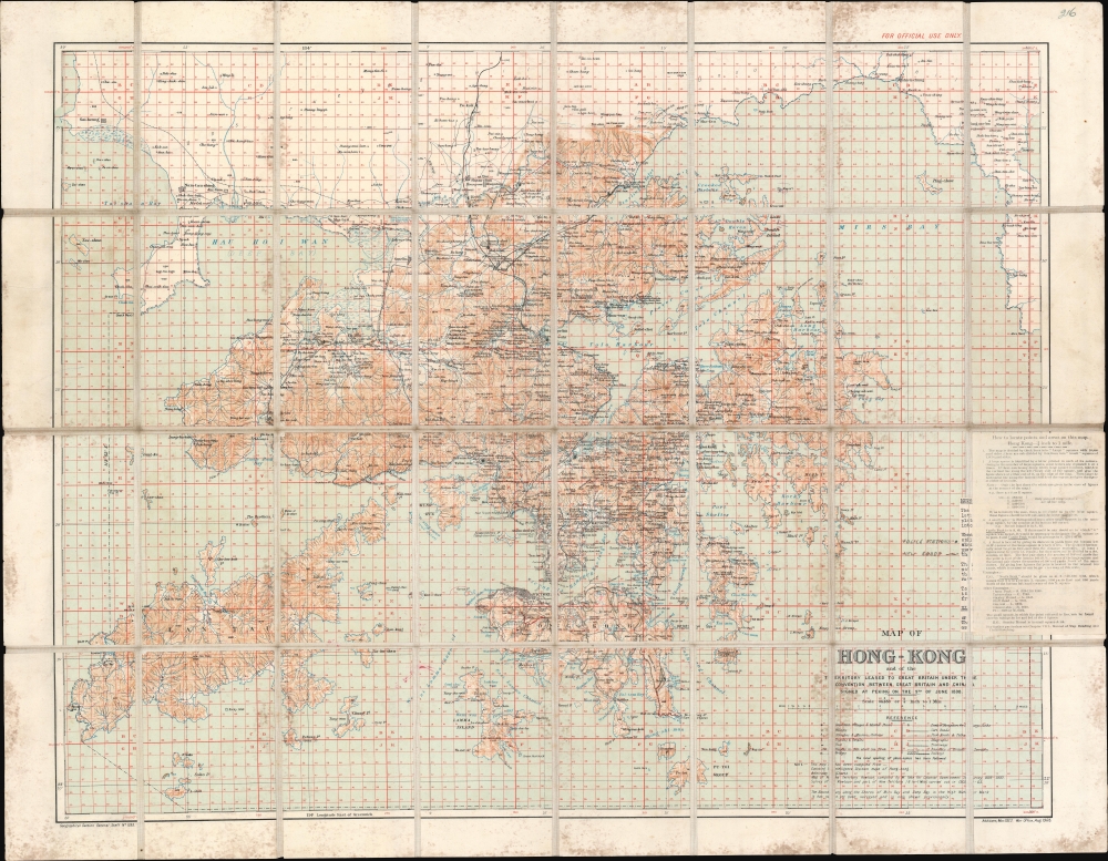
Map of Hong Kong and the Territory Leased to Great Britain under the Convention Between Great Britain and China Signed at Peking on the 9th of June 1898.
1922 (dated) 29.625 x 38.25 in (75.2475 x 97.155 cm) 1 : 84480
1922 (dated) 29.625 x 38.25 in (75.2475 x 97.155 cm) 1 : 84480
Description
This is a 1922 British War Office map of Hong Kong and the New Territories. It was issued in March of 1922, shortly following the historic Hong Kong Seaman's Strike.
A Closer Look
Coverage embraces Hong Kong from Tai-shan Bay to Mirs Point and from China to Po Toi (Pu Toi). Cities, towns, and villages are labeled throughout the Crown Colony, including Victoria and Kowloon. In Victoria, Murray Barracks, the hospital, the sugar refinery, and the Tai-ku Sugar Factory are identified. Roads are illustrated, and topography is illustrated using contours. Manuscript notations mark police stations in the New Territories and several newly constructed roads. Bays, channels, and other coastal locations are also noted. The entire chart is overlaid by a grid meant to make finding a specific location easier. Instructions on how to use this grid are included via a pastedown along the right border.Hong Kong Seamen's Strike of 1922
In January 1922, the Seaman's Strike disrupted commerce in the region. At the time, there was an extraordinary gap between the wages paid to Chinese and British seamen. Seeking more equitable treatment, over 30,000 Chinese seamen from Hong Kong and Canton (Guangzhou) declared a strike. The strike lasted 52 days. By February, over $5 million in cargo was floundering in Hong Kong Harbor and shipping companies began bypassing the island. By early March, the city was near anarchy, with food rationed, trash piling up, businesses closed, and public transportation halted. On March 5, the shipping companies eventually backed down and agreed to a 15-30% wage increase.Publication History and Census
This map was created by the Geographical Section of the General Staff of the British War Office. The first edition was published in 1905, and the current example was published in 1922. We note four examples in institutional collections at the British Library, the University of Kansas, the University of British Columbia, and the National Library of Scotland. We are aware of only one other instance when this chart entered the private market.Cartographer
The British War Office (1857 - 1964) was a department of the British Government responsible for the administration of the Royal Army until 1964, when its functions were transferred to the Ministry of Defense. The War Office was to the Royal Army what the Admiralty was to the Royal Navy, and later, the Air Ministry. Within the War Office, the General Staff Topographical Section was responsible for thousands of maps issued for British intelligence and military use. The Topographical Section was renamed Geographical Section in April 1907. Many, once their military use passed, were offered through licensed agents to the general public. The sole London agent for War Office material was Edward Stanford. More by this mapmaker...
Condition
Very good. Dissected and mounted on linen in 32 panels. Soiling. Paste down map reading instructions adhered to third panel from top in far right column.
References
OCLC 779582655.