
This item below is out of stock, but another example (left) is available. To view the available item, click "Details."
Details
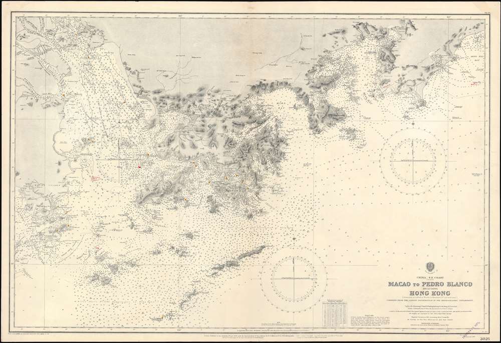
1929 Admiralty Nautical Chart or Map of Hong Kong
$2,000.00
1929 Admiralty Nautical Chart or Map of Hong Kong
HongKongMacao-admiralty-1929$1,250.00

Title
China _ S.E. Coast. Macao to Pedro Blanco including Hong Kong.
1929 (dated) 27.5 x 40.5 in (69.85 x 102.87 cm) 1 : 186000
1929 (dated) 27.5 x 40.5 in (69.85 x 102.87 cm) 1 : 186000
Description
A rare 1929 British Admiralty nautical chart or maritime map of Hong Kong and vicinity. Centered on Hong Kong, the map includes Kowloon and the New Territories, it extends west as far as Macao, and east to Hong Hai Bay. The chart exhibits manuscript updates in a practiced hand.
Census and Publication History
This chart was first published in 1899, with the present example being updated to 1929. In the 1960s, the U.S. Navy issued a similar chart of the same title. The map appears in the OCLC in an 1899 and a 1960 edition, but no institutional holdings are identified. We have been able to trace no other examples of the present edition and no verifiable examples of earlier editions.Cartographer
The British Admiralty Office (1795 - Present) or the United Kingdom Hydrographic Office refers to the Branch of the English government that is responsible for the command of the British Navy. In 1795 King George III created the United Kingdom Hydrographic Office, known in short as the U.K.H.O., to provide top notch nautical charts to the vast Royal Navy. Prior the founding of the Admiralty the surveying and creation of nautical charts was primarily a commercial venture wherein the cartographer himself, more of than not, actually financed the printing of his own material. The great navigator Cook himself is known to have scrambled for funds to publish his own seminal charts - the most important and advanced of the period. The system of privately funded nautical mapping and publishing left vast portions of the world uncharted and many excellent charts unpublished. King George III, responding significant loss in trade revenue related to shipwrecks and delay due to poor charts, recognized the need for an institutionalized government sponsored cartographic agency - the Admiralty. The first head of the Admiralty, a position known as Hydrographer, was the important cartographer Alexander Dalrymple. Dalrymple started by organizing and cataloging obtainable charts before initiating the laborious process of updating them and filling in the blanks. The first official Admiralty Chart appeared in 1800 and detailed Quiberon Bay in Brittany. By 1808 the position of Hydrographer fell to Captain Thomas Hurd. Hurd advocated the sale of Admiralty charts to the general public and, by the time he retired in 1829, had issued and published some 736 charts. Stewardship of the organization then passed to Rear Admiral Sir Francis Beaufort. It was under Beaufort's administration that the Admiralty truly developed as a "chart making" as opposed to a "chart cataloging" institution. Beaufort held his post from 1829 to 1854. In his 25 years at the Admiralty Beaufort created nearly 1500 new charts and sponsored countless surveying and scientific expeditions - including the 1831 to 1836 voyage of the H.M.S. Beagle. By 1855 the Admiralty's chart catalog listed some 1,981 charts. More by this mapmaker...
Condition
Very good. Manuscript corrections. Original centerfold.
References
OCLC 557702953.