This item has been sold, but you can get on the Waitlist to be notified if another example becomes available, or purchase a digital scan.
1778 Zatta Map of Canada and Greenland: Hudson Bay and Baffin Bay
HudsonBay-zatta-1778$150.00

Title
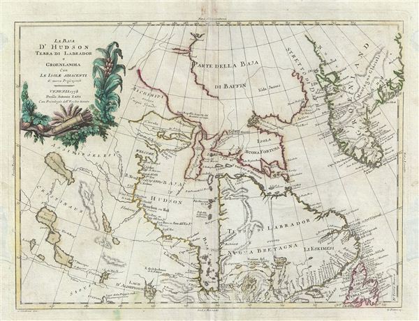
La Baja d'Hudson Terra di Labrador e Groenlandia con le Isloe Adiacenti di nuova Projezione.
1778 (dated) 13 x 18 in (33.02 x 45.72 cm)
1778 (dated) 13 x 18 in (33.02 x 45.72 cm)
Description
This map is a hand colored 1778 A. Zatta map of the Hudson Bay. Centered on the Hudson Bay, it covers from Baffin Bay (North Atlantic Ocean) to James Bay. Includes the Hudson Bay, southern Greenland, Labrador and Newfoundland. The map offers excellent detail throughout especially regarding the topography of Greenland and the waterways extending westward form the Hudson Bay. During the late 18th century most had given up all hope of finding a water route through the Arctic to the Pacific, however, hope remained that a river passage was possible. The network of lakes and rivers extending westward from the Hudson Bay and the Great Lakes was the best hope for such a route. Here Zatta connects Lake Winnepeg (Ouinipigon) via a series of rivers and lakes to the Hudson Bay. He also leave a number of entradas, including the entrada di Chesterfield and Michinipi, open at the west. This map was issued as part of A. Zatta's 1776 publication of Storia Dell' America Settentrionale Del Signor Abate Raynal Continuata fino al present, con Carte Geografiche rappresentanti il Teatro della Guerra Civile tra la Gran Bretagna, e le Colonie Unite.
Cartographer
Antonio Zatta (1775 - April 2, 1797) was the most prominent Italian map publisher of the late 18th and early 19th century. His firm, based in Venice, produced maps that mark an important transition from 18th to 19th century cartographic styles. He updates and redefines the traditional title cartouche by replacing the mythic elements common to the 17th and 18th century with more representative images. His maps also strive to keep many 18th century details, such as figural depictions on the map itself, while striving for the accuracy that a 19th century clientele demanded. His most important work is the four volume Atlante novissima published from 1775 to 1789. More by this mapmaker...
Source
Zatta A., Atlante Novissimo, 1784. Also in, Zatta A., Storia Dell' America Settentrionale Del Signor Abate Raynal Continuata fino al present, con Carte Geografiche rappresentanti il Teatro della Guerra Civile tra la Gran Bretagna, e le Colonie Unite, 1778.
Condition
Very good. Blank on verso. Original centerfold. Restoration done on both left and right margins.
References
Rumsey 5007.015. Kershaw, K., Early Printed Maps of Canada, #479.