
Zatta, Antonio (Antonio Zatta e figli Librai e Stampatori)
Antonio Zatta (1722 - February 16, 1804) was a Venetian printer and publisher whose illustrated books and atlases made him a leading figure in late 18th-century Italian publishing. Born in Venice into a printing family active since 1656, he attempted to relocate to Rovereto in 1752, but Venetian authorities blocked the move. The merchant Amedeo Svajer financed his early ventures. His connections with the Jesuits, including publications defending the order under false imprints (1760 - 1761), attracted controversy, although these ties weakened during the 1760s. Geography became a major undertaking: he published Anton Friedrich Büsching's Nuova geografia in 34 volumes (1773 - 1782), followed by the four-volume Atlante novissimo, illustrato ed accresciuto (1779 - 1785), comprising approximately 240 maps. Portions appeared separately, notably Le colonie unite dell'America settentr.le, an Italian adaptation of John Mitchell's 1755 map. His geographical publications also included Cook's voyages (1794 - 1795) and the map-illustrated political periodical Prospetto degli affari attuali dell'Europa (1788 - 1801). Beyond cartography, he published literature, medicine, and Buffon's natural history (1782 - 1791), cultivating collaborations with leading Venetian illustrators and engravers. His sons Giacomo and Giovanni joined the business in 1783; the printing house closed shortly after his death.
AKA: Antonio Zatta e figli Librai e Stampatori
References: Infelise, Mario. 'Zatta, Antonio', Dizionario Biografico degli Italiani, vol. 100, (Rome: Istituto della Enciclopedia Italiana) 2020.
An Ostrich, Elephant, and Alligator walk into the Northwest Passage...
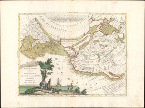
Nuove Scoperte De'Russi al Nord del Mare del Sud si nell'Asia, che nell'America.
$1,200.00
Acquire
- Digital Map Information
- Suitable for large format printing
- Full resolution TIFF file
- ICC color profile embedded
- Delivered instantly via download link
This is Antonio Zatta's 1776 map of the North Pacific, a richly decorative vision of northwestern America before Cook's surveys transformed European understanding of the region. Extending from Hudson Bay and the Great Lakes westward to Siberia and Japan, it assembles an extraordinary collection of geographical conjectures: de Fonte's Northwest Passage, the Strait of Anian, a supposed Chinese colony, the River of the West, and the legendary lands of Quivira and Teguayo. Russian discoveries mingle with imaginary waterways and misplaced kingdoms, capturing a moment when exploration and speculation shared the same map. (more details)
Crossroads of the North American Fur Trade.
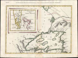
Folg. I. Il Paese deʼ Selvaggi Outauacesi, e Kilistinesi Intorno al Lago Superiore.
$750.00
Acquire
- Digital Map Information
- Suitable for large format printing
- File Size: 12.26 MB
- File Type: ZIP / TIFF
- ICC color profile embedded
- Delivered instantly via download link
This is Antonio Zatta's 1778 map of Lake Superior and environs, issued at the height of the American Revolutionary War (1775 - 1783). Although separately published, the sheet forms Plate I of Zatta's 12-sheet Italian edition of John Mitchell's seminal map of eastern North America. Zatta, however, includes additions not present on Mitchell's map, relating to the names of rivers, native peoples, and settlements. (more details)
Second Anglo-Mysore War.
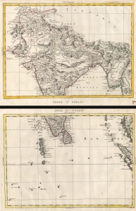
Indie Imo. Foglio. / Indie IIo. Foglio.
$1,200.00
Acquire
- Digital Map Information
- Suitable for large format printing
- Full resolution TIFF file
- ICC color profile embedded
- Delivered instantly via download link
This is a 1784 Antonio Zatta 2 sheet map of India. Published as the British East India Company was fighting to bring all of India within its sphere. At it went to the presses, the British East India Company and the Kingdom of Mysore were at a war, partially ignited by the American Revolutionary War (1775 - 1783), known as the Second Anglo-Mysore War (1780 - 1784). (more details)
Includes the mythical Laguna de Xarayes - the supposed gateway to El Dorado.
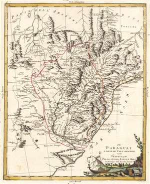
Il Paraguai E Parte Dei Paesi Adiacenti.
$350.00
Acquire
- Digital Map Information
- Suitable for large format printing
- DPI: 600
- File Size: 26.34 MB
- File Type: ZIP / TIFF
- ICC color profile embedded
- Delivered instantly via download link
A beautiful example of Antonio Zatta's 1785 map of Paraguay. The map embraces the Rio de la Plata watershed well into Brazil and the Amazon, and includes the modern-day nations of Uruguay, Paraguay, and parts of adjacent Brazil and Argentina. Rich detail is offered throughout, naming mountains, rivers, national boundaries, cities, regions, and indigenous tribes. Identifies Asuncion, Buenos Aires, Rio de Janeiro, and numerous other important South American cities. (more details)
Scarce map of the Philippines.
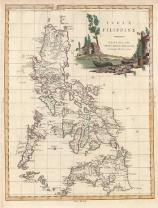
Isole Filippine.
$1,800.00
Acquire
- Digital Map Information
- Suitable for large format printing
- DPI: 600
- File Size: 25.45 MB
- File Type: ZIP / TIFF
- ICC color profile embedded
- Delivered instantly via download link
This is Antonio Zatta's elegant 1785 representation of the Philippine archipelago. It is based on the 1734 map of Pedro Murillo Velarde, S. J., considered the most important map in the history of the Philippines. (more details)