1724 Homann Map of Hungary
Hungary-homann-1724$550.00
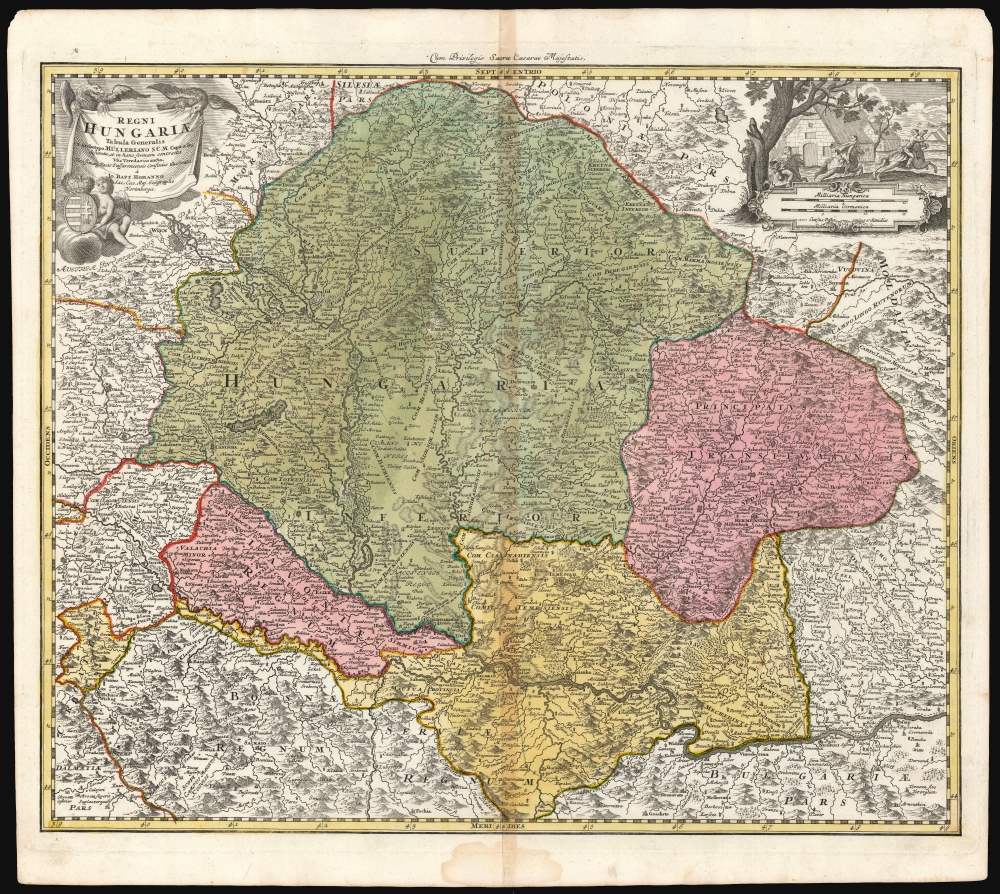

Title
Regni Hungariae tabula generalis ex archetypo Mülleriano SCM capit. et ing.
1724 (undated) 18.5 x 22.25 in (46.99 x 56.515 cm) 1 : 1400000
1724 (undated) 18.5 x 22.25 in (46.99 x 56.515 cm) 1 : 1400000
Description
This is Johann Baptist Homann's 1724 map of the Kingdom of Hungary, based on the comprehensive 1699 surveys of Johann Christoph Müller. These were undertaken to measure the bounds of Hungary following the Ottoman Empire's surrender at the treaty of Karlowitz. Consequently, this represented the new frontier with the Ottoman Empire following the treaty.
A Closer Look
The map embraces Hungary, Transylvania, Serbia, and Slavonia, with parts of Bosnia and Moldavia, now comprised of Hungary, parts of Croatia, Bosnia, Serbia and Romania, Slovakia, part of Czechia, and the eastern limits of Austria. Mountains, forests, and lowlands are shown pictorially. Important roads and some archaeological features are indicated.Allegorical Engraving
The cartouche in the upper left is presented in a banner motif, suspended by a pair of eagles. A putto sits on a cloud in the foreground, supporting the arms of the Kingdom of Hungary. At the upper right, above the map's scales, is an equestrian vignette of three horsemen, one blowing a horn, with headgear suggesting they may be Turkish. They ride past stone buildings, and in the background a steeple is adorned with a crescent, indicating a Muslim town. Given that the map represents Europe's new borders with a retreating Ottoman Empire, the vignette may well represent the Ottomans fleeing their previously-held territory.Publication History and Census
This map's printing history is convoluted. We have identified at least two plates, and evidence that several of these were vigorously reworked over the course of the 18th century, either by Homann or his heirs. The first was engraved c. 1716, and it appeared in Homann Heirs atlases until 1778. A copy of this map, from a second plate, is dated 1724 by the Bibliothèque nationale de France. The present example appears to be an earlier state of the BnF's example, but lacking better data we are inclined to adopt this date. Homann's shop produced faithful copies of the map itself, but with variation in the execution of topography and lettering. The most obvious changes from each version can be traced in the face of the cartouche's putto, whose variations both of facial type and overall expression are extreme. The map appears to be well represented in institutional collections in its various iterations, but it is difficult to determine specific versions from catalog listings. It appears on the market from time to time.CartographerS
Johann Baptist Homann (March 20, 1664 - July 1, 1724) was the most prominent and prolific map publisher of the 18th century. Homann was born in Oberkammlach, a small town near Kammlach, Bavaria, Germany. As a young man, Homann studied in a Jesuit school and nursed ambitions of becoming a Dominican priest. Nonetheless, he converted to Protestantism in 1687, when he was 23. It is not clear where he mastered engraving, but we believe it may have been in Amsterdam. Homann's earliest work we have identified is about 1689, and already exhibits a high degree of mastery. Around 1691, Homann moved to Nuremberg and registered as a notary. By this time, he was already making maps, and very good ones at that. He produced a map of the environs of Nürnberg in 1691/92, which suggests he was already a master engraver. Around 1693, Homann briefly relocated to Vienna, where he lived and studied printing and copper plate engraving until 1695. Until 1702, he worked in Nuremberg in the map trade under Jacob von Sandrart (1630 - 1708) and then David Funck (1642 - 1709). Afterward, he returned to Nuremberg, where, in 1702, he founded the commercial publishing firm that would bear his name. In the next five years, Homann produced hundreds of maps and developed a distinctive style characterized by heavy, detailed engraving, elaborate allegorical cartouche work, and vivid hand color. Due to the lower cost of printing in Germany, the Homann firm could undercut the dominant French and Dutch publishing houses while matching their diversity and quality. Despite copious output, Homann did not release his first major atlas until the 33-map Neuer Atlas of 1707, followed by a 60-map edition of 1710. By 1715, Homann's rising star caught the attention of the Holy Roman Emperor Charles VI, who appointed him Imperial Cartographer. In the same year, he was also appointed a member of the Royal Academy of Sciences in Berlin. Homann's prestigious title came with several significant advantages, including access to the most up-to-date cartographic information as well as the 'Privilege'. The Privilege was a type of early copyright offered to very few by the Holy Roman Emperor. Though less sophisticated than modern copyright legislation, the Privilege offered limited protection for several years. Most all J. B. Homann maps printed between 1715 and 1730 bear the inscription 'Cum Priviligio' or some variation. Following Homann's death in 1724, the firm's map plates and management passed to his son, Johann Christoph Homann (1703 - 1730). J. C. Homann, perhaps realizing that he would not long survive his father, stipulated in his will that the company would be inherited by his two head managers, Johann Georg Ebersberger (1695 - 1760) and Johann Michael Franz (1700 - 1761), and that it would publish only under the name 'Homann Heirs'. This designation, in various forms (Homannsche Heirs, Heritiers de Homann, Lat Homannianos Herod, Homannschen Erben, etc.) appears on maps from about 1731 onwards. The firm continued to publish maps in ever-diminishing quantities until the death of its last owner, Christoph Franz Fembo (1781 - 1848). More by this mapmaker...
Johann Christoph Müller (March 15, 1673 - June 21, 1721) was a German cartographer, military engineer, and astronomer. Having been schooled in the humanities, he was then trained in mathematics and drawing by astronomer and engraver G. C. Eimmart. Beginning in 1696, he served as an officer of the Engineer Corps, carrying out astronomical observations in and around Vienna, and conducting surveys. Following the 1699 treaty of Karlowitz he was appointed to collect data for an accurate map of Hungarian territory. This resulted in a map drawn to 24 sheets, the original of which survives in the Cartographic Collection of the National Library in Vienna, with a complete copy in War Archives in Vienna. He would in 1709 produced a large map of Hungary along with Croatia, Slavonia, and Transylvania. Between 1708 and 1712 he surveyed Moravia by county and in 1720 published a four sheet copperplate map of Moravia, and produced a survey of Bohemia; this 25 sheet Mappa geographica Regni Bohemia was published posthumously in 1722. Learn More...
Source
Homann, J. B. and Homann, J. C., Neuer Atlas bestehend in einig curieusen Astronomischen Kuppren und vielen auserlesenen accuratensten Land-Charten über die Gantze Welt, (Nuremberg: Homann), 1728.
Homann's Neuer Atlas bestehend in einig curieusen Astronomischen Kuppren und vielen auserlesenen accuratensten Land-Charten über die Gantze Welt was first publihsed in 1707 with 33 maps. A second edition followed in 1710 with 60 maps. Subsequent editions followed until about 1730. The title page notes proudly that the atlas features measurements based on the 'Copernican principle of the moving sky', a truly state-of-the-art innovation for the period. Regardless of editions, collations of the atlas are inconsistent, with some examples having less, while others have more maps - a consequence of the fact that the map sheets were delivered loose, to be bound at the buyer's discretion, and so some buyers chose to omit maps they did not consider relevant, or add others they did. Between editions, the constituent maps, particularly of European regions, were regularly updated to reflect the most recent political events. The atlas continued to be published by Homann's son, J. C. Homann (1703 - 1730), and then by Homann Heirs. Most examples also feature a fine allegorical frontispiece with the title Atlas Novus Terrarum Orbis Imperia, regna et Status, which was used for multiple Homann atlases, including the Neuer Atlas and the Atlas Minor.
Condition
Very good. Toning at centerfold. Original wash and outline color.
References
OCLC 165806517. Not in Rumsey.