This item has been sold, but you can get on the Waitlist to be notified if another example becomes available, or purchase a digital scan.
1513 Waldseemüller Map of Eastern Europe- the First Modern Map of Hungary, Poland, Russia, Prussia
HungaryPoland-waldseemuller-1513$3,250.00

Title
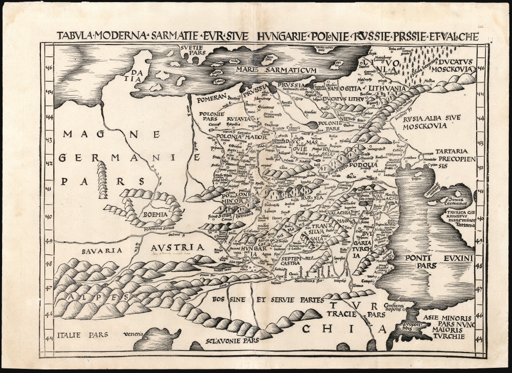
Tabula Moderna Sarmatie Eur. Sive Hungarie Polonie Russie Prussie Et Walachie.
1513 (undated) 15.5 x 21.5 in (39.37 x 54.61 cm) 1 : 3700000
1513 (undated) 15.5 x 21.5 in (39.37 x 54.61 cm) 1 : 3700000
Description
This is Martin Waldseemüller's 1513 map of Eastern Europe, covering from the Elbe River to the Dnipro River and the Black Sea - roughly Poland, Hungary, Prussia, Lithuania, Russia, Transylvania, and Bulgaria, and some of the earliest obtainable mappings of the Ukraine.
Waldseemüller's map is set in the framework of a Cusanus-type map. From the Oder River to points east, it is derived from the 1507 Tabula Moderna Poloniae Ungarie Boemie Germanie Russie Lithuanie, published in the 1507 Rome edition of Ptolemy as a tabula moderna by Marco Beneventano, and revised by the great Polish cartographer Bernard Wapowski. Waldseemüller does not reproduce the Benevento/Wapowski from the Oder River westwards. He had a superior tabula moderna for Germany, whose overall outline here replaces that of the Beneventano. The only other generally acquirable derivative of the Cusanus map, the 1493 Schedel, presents only sparse detail east of the Oder, and as such it is more of interest to the Germany collector than to those focusing on the Eastern Europe. Waldseemüller's decision not to reproduce the Beneventano's Germany emphasizes the contributions of Wapowski to the map, making it the earliest acquirable mapping of Poland derived from information from a Pole. Its treatment of Ukraine, Muscovy, Lithuania, and Livonia are all superior to that of earlier derivatives of the Cusanus maps, making this an important component in any collection focusing on those areas.
A Closer Look
Although the topographical framework of the map beholden to the 2nd century precedent of Claudius Ptolemy, this map is updated to reflect the contemporaneous mapping of Poland, Hungary, Prussia, Lithuania, Russia, Transylvania, and Bulgaria. Mountains and forests are indicated pictorially. Many cities are named, including Venice, Constantinople, Vilna, Kaunas, Kiev, Krakow, Warsaw, Gdansk, Riga, Smolensk, and Moscow. The glimpses of Ukraine that appear are among the earliest available to the collector. This map was one of the modern maps added to Waldseemüller and Ringmann's 1513 Ptolemy. We believe the present example to be a second edition of 1520, but both editions nevertheless remain the earliest appearance of this geography available to the collector.Scope and Lineage of the Map
Waldseemüller's map fits in a narrative of maps, nearly all unacquirable, derived from the 15th century map of Nicolas Cusanus. All maps of this lineage share roughly the same scope, reaching from Flanders to the Dnipro River, and from Denmark to northern Italy. Cusanus' map would have been in absolute terms the earliest modern map to detail the regions from Germany to Poland and Ukraine. Manuscript examples by Martellus have survived; a printed version of 1491 originating from Donnus Nicolaus Germanus exists in the Bibliothèque nationale de France. No original maps by Cusanus survive. His sources are unknown, but the broad topography remained essentially Ptolemaic as is evident in the delineations of the Baltic coast and the Black Sea.Waldseemüller's map is set in the framework of a Cusanus-type map. From the Oder River to points east, it is derived from the 1507 Tabula Moderna Poloniae Ungarie Boemie Germanie Russie Lithuanie, published in the 1507 Rome edition of Ptolemy as a tabula moderna by Marco Beneventano, and revised by the great Polish cartographer Bernard Wapowski. Waldseemüller does not reproduce the Benevento/Wapowski from the Oder River westwards. He had a superior tabula moderna for Germany, whose overall outline here replaces that of the Beneventano. The only other generally acquirable derivative of the Cusanus map, the 1493 Schedel, presents only sparse detail east of the Oder, and as such it is more of interest to the Germany collector than to those focusing on the Eastern Europe. Waldseemüller's decision not to reproduce the Beneventano's Germany emphasizes the contributions of Wapowski to the map, making it the earliest acquirable mapping of Poland derived from information from a Pole. Its treatment of Ukraine, Muscovy, Lithuania, and Livonia are all superior to that of earlier derivatives of the Cusanus maps, making this an important component in any collection focusing on those areas.
A New Ptolemy
This map appeared first in the 1513 edition of Claudius Ptolemy's Geographia, whose translation and maps were the collaboration of Martin Waldseemüller and Matthias Ringmann, who are best known for their 1507 world map, the monumental Universalis Cosmographia. Starting with the maps printed in the 1482 Ulm Ptolemy, Waldseemüller and Ringmann consulted a variety of Greek and Latin manuscript copies of Ptolemy in order to produce an authoritative, corrected edition of the classical proto-atlas. In addition to the twenty-seven maps based strictly on Ptolemy's data, it included twenty Tabulae Modernae. Among these maps are the first printed maps to focus on regions unknown to Ptolemy such as North America and southern Africa, but they also include maps of areas covered in Ptolemaic geography but with new topography and toponymy based on contemporaneous information, such as the maps of Lorraine and the upper Rhine (which Waldseemüller probably surveyed himself) and a map of Crete. Ironically, Waldseemüller's name did not appear in the published book, as he and Ringmann had had a falling out and by 1513 the two were no longer working together.Publication History and Census
This map was drawn between 1507 and 1513 by Martin Waldseemüller as part of his work with the Gymnasium Vosagense, an association of humanist scholars formed in Saint-Dié under the patronage of the Duke of Lorraine. The map was included in the Gymnasium's 'Geographie Opus Novissima Traductione E Graecorum Archetypis,' printed in 1513 by Johannes Schott in Strasbourg. Schott published a single further edition of the book in 1520 titled Ptolemaeus auctus restitutus emaculatus cum tabulis veteribus ac novis. While there was no alteration to the map, close inspection reveals a faint crack to the woodblock (entering the right-hand border at 40 degrees) which is visible in confirmed examples of the 1520 edition, but absent in the 1513. While it is possible that the crack developed during the course of printing the 1513 edition, its presence here on this example strongly suggests that this is from a 1520 edition of Waldseemüller and Ringmann's work. Two examples of this map are cataloged as 1520 editions in OCLC at the Bayerisch Staatsbibliothek, Universitatsbibliothek Eichstatt. Three examples dated 1513 appear in those institutions as well as the National Library of Poland, but lacking digital imagery of these it is impossible to confirm their dates. The map appears on the market from time to time, with 1520 examples very frequently presented as 1513.CartographerS
Martin Waldseemüller (September 11, 1470 - March 16, 1520) was a German cartographer, astronomer, and mathematician credited with creating, along with Matthias Ringmann, the first map to use the placename America. He was born in Wolfenweiler, near Freiburg im Breisgau. Waldseemüller studied at the University of Freiburg and, on April 25, 1507, became a member of the Gymnasium Vosagese at Saint-Dié. Martin Waldseemüller was a major proponent of theoretical or additive cartography. Unlike contemporary Portuguese and Spanish cartographers, who left maps blank where knowledge was lacking, Waldseemüller and his peers speculated based upon geographical theories to fill unknown parts of the map. He is best known for his Universalis Cosmographia a massive 12-part wall map of the world considered the first map to contain the name America, today dubbed as 'America's Birth Certificate'. This map also had significance on other levels, as it combined two previously unassociated geographical styles: Ptolemaic Cartography, based on an ancient Greek model, and the emergent 'carta marina', a type of map commonly used by European mariners in the late 15th and 16th centuries. It also extended the traditional Ptolemaic model westward to include the newly discovered continent of America, which Waldseemüller named after the person he considered most influential in its discovery, Amerigo Vespucci. When Waldseemüller died in 1520, he was a canon of the collegiate Church of Saint-Dié. In contemporary references his name is often Latinized as Martinus Ilacomylus, Ilacomilus, or Hylacomylus. More by this mapmaker...
Bernard Wapowski (1475-1535) a Polish cartographer, is credited with the first contemporaneous map of Poland in 1526. He was born in Wapowce near Przemyśl, but virtually nothing is known of his early life. While in Rome as part of Erasme Ciołk's Polish Embassy between 1505 and 1506, he produced his first map of Poland. He enjoyed influence there, gaining introduction to the Pope and the protection of Cardinal Peirre Jules II. Wapowski stayed in Rome for several years at the Court of the Holy See where he worked on his map of Jagellonian Poland, based on Nicolas de Cuse's 1491 map. He is thought to have drawn the Ptolemaic maps covering Poland and Kievan Rus for the 1507 and 1508 Rome Ptolemies. By 1526 Wapowski was secretary to the King Sigismund the Old. At that time, he producd a map of Poland and the Grand Duchy of Lithuania with the assistance of Nicolaus Copernicus, with whom he studied at the University of Kraków under Albert Brudzewski. The 1526 map would be Wapowski's most important: it was the first large-scale, detailed, contemporaneous map of Poland. Wapowski's maps are now all lost except in a few surviving fragments. Despite this, his work was powerfully influential in the 16th century, providing the basis for the mapping of Poland and Hungary by Münster, Ortelius, Mercator and others. He is underdstood to have had assistance from Nicolaus Copernicus. The astronomer also learned from Wapowski during their longtime friendship, producing his own map of Prussia in 1510. Wapowski also wrote a continuation of Jan Długosz's History of Poland. Learn More...
Source
Waldseemüller, M. / Ringmann, M., Ptolemaeus auctus restitutus emaculatus cum tabulis veteribus ac novis, (Strasbourg: Schott) 1520.
Condition
Very good. Centerfold reinforced with old mend at bottom, with a small area of manuscript restoration. Else excellent with a bold strike.
References
OCLC 165587677. Not in Malinowski.