1815 Thomson Map of Spain and Portugal
Iberia-thomson-1815$300.00

Title
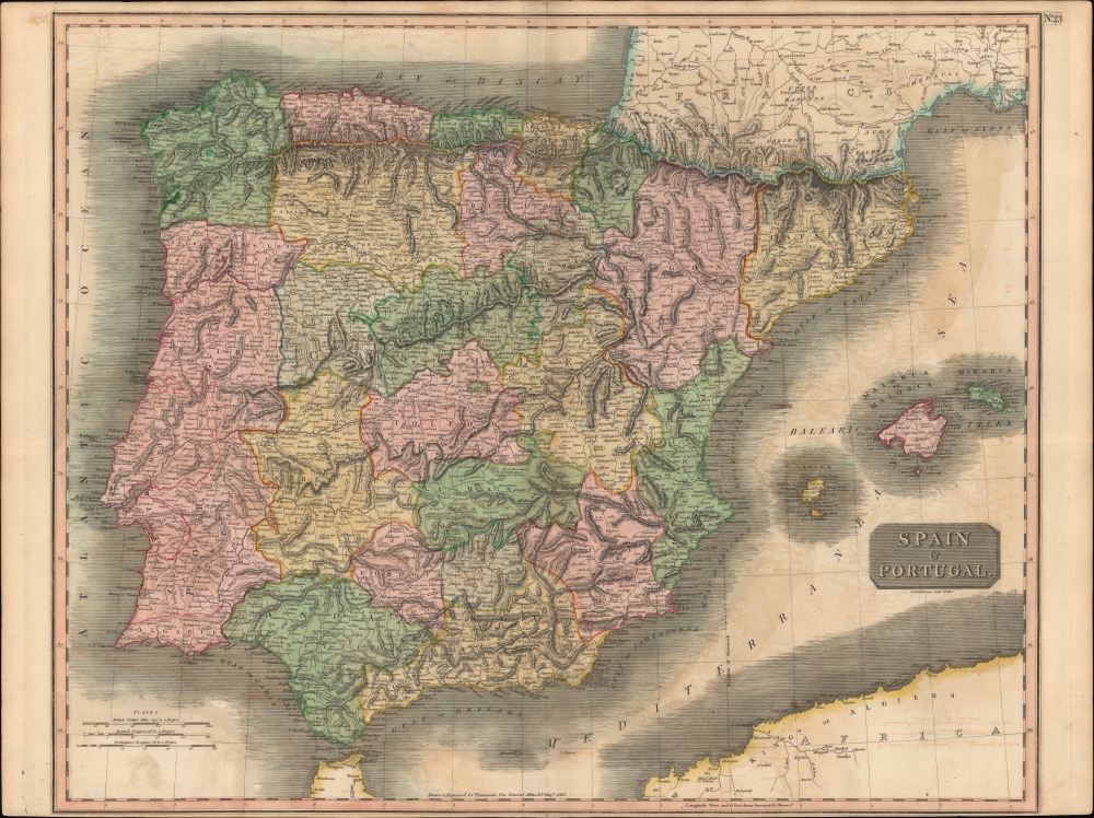
Spain and Portugal.
1815 (dated) 26.25 x 20.75 in (66.675 x 52.705 cm) 1 : 1950000
1815 (dated) 26.25 x 20.75 in (66.675 x 52.705 cm) 1 : 1950000
Description
A hand-colored 1815 map of Spain and Portugal by John Thomson, published in his New General Atlas. It depicts the kingdoms at the tail end of the Napoleonic Wars (1803 - 1815), namely the Peninsular War, which was devastating both to Iberia and to both countries' control of their overseas empires.
A Closer Look
This fascinating map is beautifully engraved in the minimalist English style pioneered in the early part of the 19th century. It includes both countries in full, with Spain being divided into its various semi-autonomous provinces. The Balearic Islands of Minorca, Majorca, and Ibiza are prominent in the upper right. Relief is shown by hachure with towns, cities, roads, waterways (including the Imperial Canal of Aragon), and major topographical features identified.Historical Context
This map was produced at the end of the Napoleonic Wars. Spain had initially sided against Napoleon's France in the conflicts at the start of the 19th-century, but France's much larger and superior army forced Charles IV to switch sides and align with Napoleon. However, Spain and France's loss at the Battle of Trafalgar and a clumsy invasion and occupation of Portugal in 1807 led Spain seek autonomy from Napoleon, resulting in a French invasion in 1808. Much of Iberia was occupied by French troops, but several cities and regions held out, while uprisings occurred in others and guerillas constantly harassed French troops, making it a costly disruption for Napoleon, whose main focus was elsewhere. British troops under Arthur Wellesley landed in Portugal in 1808 and began a grinding but ultimately successful campaign to wrest control of Iberia from France. By 1815, Spain and Portugal were liberated, but economically and demographically devastated. Their overseas empires had seen the rise of powerful independence movements, most of which could not be defeated in counter-revolutionary conflicts in the following years.Publication History and Census
This map was prepared by John Thomson and engraved by John and George Menzies for inclusion in Thomson's New General Atlas, which went through multiple printings in both Dublin and Edinburgh. Examples of the map display different pagination (or none at all) and other minor details (such as the inclusion of Menzies brothers' names below the title here) depending on the printing, with the plate number here (No. 23) seemingly added separately from the main plate, different from another example previously sold by us as well as that held by the David Rumsey Historical Map Collection.CartographerS
John Thomson (1777 - c. 1841) was a Scottish cartographer, publisher, and bookbinder active in Edinburgh during the early part of the 19th century. Thomson apprenticed under Edinburgh bookbinder Robert Alison. After his apprenticeship, he briefly went into business with Abraham Thomson. Later, the two parted ways, John Thomson segueing into maps and Abraham Thomson taking over the bookbinding portion of the business. Thomson is generally one of the leading publishers in the Edinburgh school of cartography, which flourished from roughly 1800 to 1830. Thomson and his contemporaries (Pinkerton and Cary) redefined European cartography by abandoning typical 18th-century decorative elements such as elaborate title cartouches and fantastic beasts in favor of detail and accuracy. Thomson's principle works include Thomson's New General Atlas, published from 1814 to 1821, the New Classical and Historical Atlas of 1829, and his 1830 Atlas of Scotland. The Atlas of Scotland, a work of groundbreaking detail and dedication, would eventually bankrupt the Thomson firm in 1830, at which time their plates were sequestered by the court. The firm partially recovered in the subsequent year, allowing Thomson to reclaim his printing plates in 1831, but filed again for bankruptcy in 1835, at which time most of his printing plates were sold to A. K. Johnston and Company. There is some suggestion that he continued to work as a bookbinder until 1841. Today, Thomson maps are becoming increasingly rare as they are highly admired for their impressive size, vivid hand coloration, and superb detail. More by this mapmaker...
John Menzies (October 27, 1772 - October 16, 1857) was a Scottish engraver active in Edinburgh during the late 18th and early 19th centuries. Menzies mastered engraving as an apprentice to James Rymer. In 1811, he partnered with his younger brother, George Menzies, to found the engraving firm of J. and G. Menzies, which was active until about 1831. Later his son, also named John, joined the firm and they engraved jointly under the imprint of J. Menzies and Son. At its height, the Menzies firm employed three men and three apprentices. Menzies engraved maps for Thomas Brown and John Thomson, among others. After his death, his son, John Menzies II (1819 – 1891), continued the family business until about 1891. Learn More...
Source
Thomson, J., A New General Atlas, (Edinburgh) 1817.
Thomson's New General Atlas was first published in 1817 and continued to be published until about 1821. This is the first of Thomson's major cartographic works and the atlas for which is most celebrated. The New General Atlas follows in the Edinburgh School, which eschews excessive decoration in favor of a more minimalistic fact-based cartographic vision, as established by John Pinkerton, Laurie and Whittle, John Cary, and others in the previous decades. The maps are notable for their massive scale, heavy stock, elegant color work, and easy-to-read typefaces. Although the atlas stopped being published after 1821, Thomson continued to offer 'supplementary' maps that could be tipped into the atlas as late as 1830, when he declared bankruptcy. The maps in the Thomson Atlas were engraved by Thomas Clerk, William Dassauville, Nathaniel Rogers Hewitt, James Kirkwood, Robert Kirkwood, John Menzies, George Menzies, Edward Mitchell, John Moffatt, Samuel John Neele, Robert Scott, and James Wyld.
Condition
Good. Light offsetting. Light foxing.
References
Rumsey 1007.024. Phillips (Atlases) 731. Newberry Library: Ayer 135 T4 1817.