This item has been sold, but you can get on the Waitlist to be notified if another example becomes available, or purchase a digital scan.
1784 Bowles Map of the North Atlantic Islands: Iceland, Faroe Islands and Maelstrom
IcelandWhirlpool-bowles-1784$175.00

Title
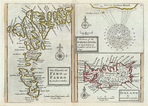
The Islands of Fero or Farro by Jacobson Debes. The Form of the Whirlpool At the South East of Sumbo with the Soundings. Iceland by Herman Moll Geographer.
1784 (undated) 7.5 x 10.5 in (19.05 x 26.67 cm) 1 : 220000
1784 (undated) 7.5 x 10.5 in (19.05 x 26.67 cm) 1 : 220000
Description
This is a singularly fascinating 1784 map of Iceland and the Faroe Islands issued by Carrington Bowles. Essentially a compilation of three maps on a single sheet, this map of the North Atlantic islands is festooned with speculations and curiosities.
The map on the left depicts the Faroe Islands. Today these stunning green islands are considered one of the most beautiful and unspoiled places on Earth. Our map depicts the Faroe Islands according a map contained in a 17th century book on the islands written by Jacobson Debes.
The Faroe Islands have been historically treacherous for mariners due to the unpredictable currents and tides surrounding them. One of the most curious and legendary results of these currents is the great maelstrom that once roared at the southern tip of Sunderoe (today Suouroy Island) - depicted on our map at the top right. This mighty whirlpool swirled around a sheer pinnacle of rock called Monek, which was said to resemble a monk from one side and a sailing ship from the other. Reports say that the whirlpool was over a mile in diameter. Soundings show that the waters surrounding the whirlpool had a depth of some 80 to 90 fathoms, but that the waters nearer the rock, at the center of the maelstrom, were but 7 to 10 fathoms deep. Sadly this startling natural phenomenon is no more. In 1884 much of Monek Rock crumbled into the sea, creating a dangerous underwater reef and displacing the unique convergence that created the maelstrom.
In the lower right hand quadrant of our chart is a map of Iceland drawn by Herman Moll. Iceland had been fairly well mapped since the late 16th century. This map, updated from earlier maps, shows the royal residence and four primary provinces.
This map was issued by Carrington Bowles in London in 1784.
CartographerS
The Bowles Family (fl. c. 1714 - 1832) were publishers and map sellers active in London from c. 1714 to c. 1832. The firm, under Thomas Bowles (fl. 1714 - 1763), John Bowles (1701 - 1779), Carrington Bowles (1724 - 1793), and as Bowles and Carver (fl. 1794 - 1832), produced a massive corpus of work that included numerous atlases, pocket maps, and wall maps. The Bowles publishing tradition was kept alive for four generations, starting with Thomas Bowles, a print engraver active in the late 17th century. His son, Thomas Bowles II, produced the firm's first maps at St. Paul's Churchyard, London. Thomas's brother, John Bowles (a.k.a. 'Old John Bowles' or 'Black Horse Bowles'), was also an active publisher established at no. 13 Cornhill. He is credited as one of the first publishers of William Hogarth's works. There, John's son, Carrington Bowles, was introduced to the trade. Carrington took over the Cornhill bookshop and eventually merged it with his uncle's shop in St. Paul's Churchyard. On Carrington's 1793 death, the business was passed to his son Henry Carrington Bowles (1763 - 1830), who partnered with his father's former apprentice Samuel Carver (1756 - 1841), renaming the firm 'Bowles and Carver'. Under this imprint, the firm continued to publish maps and atlases until 1832. Henry Carrington Bowles died in 1830, but Samuel Carver, himself in advanced years and poor health, kept it going for another 2 years before closing the business. More by this mapmaker...
Herman Moll (1654 - 1732) was an important 18th century map publisher and engraver based in London and Holland. Moll's origins are disputed with some suggesting he was born in the Netherlands and others Germany - the Moll name was common in both countries during this period. Most likely Moll was a German from Bremen, as his will, friends, and contemporaries suggest. What is known for certain is that he moved to London in 1678, possibly fleeing the Scanian War, where he worked as an engraver for Moses Pitt and other London map publishers. Around the turn of the century, Moll set up his own shop where he produced a large corpus of work known for its high quality and decorative flair. As a new émigré to England, Moll made himself more English than the English, and through his cartography proved a fierce advocate for his adopted nation. Most of Moll's early maps were issued as loose sheets that would be bound to order, however, he did publish several important atlases late in his career. Moll is said to have made the bold claim that without a doubt "California is an Island" and that he "had in [his] office mariners who have sailed round it." While California may not be an island (yet), it is true that moll had talent for attracting interesting friends and acquaintances. He frequented London's first stock exchange, Jonathan's Coffeehouse at Number 20 Exchange Alley, Cornhill. At the time Jonathan's was known as "a place of very considerable concourse for Merchants, sea faring Men and other traders" (Erleigh, The Viscount, The South Sea Bubble, Manchester: Peter Davies, Ltd., 1933, 21). Eventually this activity attracted the interest of stock brokers, who inspired by sailor's tales, sponsored the ill-fated South Sea Company, the world's first stock bubble. Moll's close circle, mostly from the Coffee House, included scientist Robert Hooke, the writers Daniel Defoe (Robinson Crusoe) and Jonathan Swift (Gulliver's Travels), the pirates William Dampier, William Hacke and Woodes Rogers, and the archeologist William Stukeley. Herman Moll's work was highly regarded for its decorative beauty and was pirated, most notably by the Irish publisher George Grierson, both in his lifetime and after his 1732 death at St. Clement Danes, London. Learn More...
Condition
Very good. Original platemark visible. Original centerfold. Blank on verso.