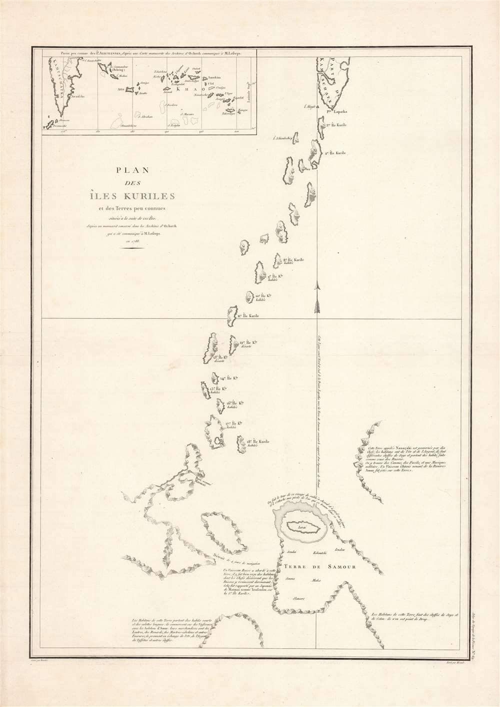
1788 La Perouse Map of the Kuril Islands
IlesKuriles-perouse-1788$400.00


Title
Plan des Iles Kuriles et des terres peu connues situees a la suite de ces Iles...
1788 (undated) 29 x 21 in (73.66 x 53.34 cm) 1 : 1900000
1788 (undated) 29 x 21 in (73.66 x 53.34 cm) 1 : 1900000
Description
Here is La Perouse's fascinating and pioneering 1788 mapping of the Kuril Islands, which his expedition charted the year prior. It is the earliest detailed chart of the islands by a European explorer, part of La Perouse's groundbreaking work, and a keystone in the developing geographical knowledge of Northeast Asia.
An inset at the top-left shows the islands directly to the east of the southern part of Kamchatka. The subtitle refers to Jean-Baptiste de Lesseps, who was the only survivor of the expedition as he disembarked at Petropavlovsk on Kamchatka and traveled overland to Paris to report on the progress of the expedition, bringing notes and this map with him.
La Perouse interacted with several groups of indigenous Ainu (on the islands marked as 'habité'), who interacted with the Japanese, Russians, and Manchus. La Perouse's cartographic efforts were aided tremendously by a map drawn for him by a group of Ainu on Sakhalin, and the ethnographic notes included here provided Europeans an early glimpse into the islands and their inhabitants.
The importance of maps for marking out and claiming territory was brought home after the expedition of Commodore Matthew Perry and American 'black ships.' Soon after the Convention of Kanagawa with the U.S., the Tokugawa signed the Treaty of Shimoda in 1855, trying to fix the border between Japan and Russia in the Kurils. In 1875, Japan and Russia signed the Treaty of Saint Petersburg, which ceded the Kurils (Chishima shotō 北海道千島諸島) to Japan in exchange for the entirety of Sakhalin (Karafuto) being ceded to Russia. As part of the treaty, the Japanese could continue to reside in the southern portion of Sakhalin.
The southern half of Sakhalin was given to Japan in the Treaty of Portsmouth in 1905 following the Russo-Japanese War (1904 - 1905) and then taken by the Soviet Union in the closing days of the World War II (1939 - 1945). The Kurils were more firmly under Japanese control before World War II but were likewise occupied by the Soviets and are administered by the Russian Federation today. The status of both the Kurils and Sakhalin remains disputed and has been a major sticking point in Soviet/Russian-Japanese relations in the postwar period.
A Closer Look
La Perouse's voyage made many important discoveries, but its most distinctive contribution was new knowledge of the Pacific around Sakhalin and the Kuril Islands. Russian traders may have been in Kamchatka as early as the mid-17th century, and Russian explorers undertook partial exploration of the Kurils both before and after La Perouse's visit. Also, Dutch mariners and European Jesuits, in the employ of Chinese emperors, collected some geographic knowledge about Sakhalin. But La Perouse's mapping was the first first-person mathematical charting of the islands - earlier maps had included them as part of the Asian mainland.An inset at the top-left shows the islands directly to the east of the southern part of Kamchatka. The subtitle refers to Jean-Baptiste de Lesseps, who was the only survivor of the expedition as he disembarked at Petropavlovsk on Kamchatka and traveled overland to Paris to report on the progress of the expedition, bringing notes and this map with him.
La Perouse interacted with several groups of indigenous Ainu (on the islands marked as 'habité'), who interacted with the Japanese, Russians, and Manchus. La Perouse's cartographic efforts were aided tremendously by a map drawn for him by a group of Ainu on Sakhalin, and the ethnographic notes included here provided Europeans an early glimpse into the islands and their inhabitants.
The Kurils and Sakhalin between Russia and Japan
Despite their reputation for xenophobia and a lack of interest in the outside world, the Tokugawa clan that unified Japan in the early 17th century did make efforts to strengthen control over frontier regions. This was delegated to daimyo relatives of the ruling family, namely the Matsumae clan. Maps from early in the Tokugawa period marked out the Kurils as part of the shogun's domain, one portion of a larger northern frontier known as Ezo (often as Yezo or Yeso in European sources, with Sakhalin as Oku-Yeso), although understanding of the geography of the Kurils was limited.The importance of maps for marking out and claiming territory was brought home after the expedition of Commodore Matthew Perry and American 'black ships.' Soon after the Convention of Kanagawa with the U.S., the Tokugawa signed the Treaty of Shimoda in 1855, trying to fix the border between Japan and Russia in the Kurils. In 1875, Japan and Russia signed the Treaty of Saint Petersburg, which ceded the Kurils (Chishima shotō 北海道千島諸島) to Japan in exchange for the entirety of Sakhalin (Karafuto) being ceded to Russia. As part of the treaty, the Japanese could continue to reside in the southern portion of Sakhalin.
The southern half of Sakhalin was given to Japan in the Treaty of Portsmouth in 1905 following the Russo-Japanese War (1904 - 1905) and then taken by the Soviet Union in the closing days of the World War II (1939 - 1945). The Kurils were more firmly under Japanese control before World War II but were likewise occupied by the Soviets and are administered by the Russian Federation today. The status of both the Kurils and Sakhalin remains disputed and has been a major sticking point in Soviet/Russian-Japanese relations in the postwar period.
Publication History and Census
This map was drawn by La Perouse in 1787, carried by Jean-Baptiste de Lesseps across Eurasia in 1788, and published posthumously as Plate No. 69 in the first edition of the Atlas du Voyage de la Perouse. It was engraved by Bouclet, edited by Hérault (no further information is available), and published in Paris by the Imprimerie de la Republique in 1797. Due to variations in cataloging, it is difficult to precisely determine its distribution, but both the map and the entire atlas are known to be held by a handful of libraries in North America and Europe.Cartographer
Jean François de Galaup, Comte de La Pérouse (August 23, 1741 - 1788) was a French naval officer, navigator, and explorer active in the later part of the 18th century. Born into a noble family of Albi, France, La Perouse entered the navel college of Brest at just 15. At seventeen La Perouse made his first naval voyage, a supply expedition to the fort of Louisbourg in New France. He later participated in a number of naval battles, mostly against the English, and eventually rose to the rank of Commodore. In 1782 he captured the English forts Prince of Wales and York, making a name for himself back in France. Following the British defeat at the end of the American Revolutionary War, La Perouse was appointed by Louis XVI to lead an expedition of discovery circumnavigating the globe. The goal of the expedition was to complete and correct the maps of the Pacific drawn by Captain Cook. La Perouse's two frigates, the Astrolabe and the Boussole rounded Cape Horn and entered the Pacific in 1785. Crisscrossing the Pacific from Macau and Japan to Alaska, Vancouver, and the Hawaiian Islands Perouse made numerous discoveries and adding considerably to the cartographic corpus, particularly along the coast of British Columbia and around Japan. In Australia La Perouse sent his last letter back to France containing all of his maps and research. Tragically, on the return voyage La Perouse ran into a violent storm which left both of his frigates shipwrecked on the Polynesian island of Vanikoro, part of the Santa Cruz Group. Some of the survivors of the shipwrecks seem to have managed to live on the island for years afterwards. As late as 1790 the English Captain Edward Edwards saw smoke signals coming from Vanikoro but foolishly declined to investigate. Expeditions in 2005 and in 2008 identified the remains of both ships and retuned numerous artifacts from the ill-fated expedition to France. The importance of La Perouse's discoveries was, unfortunately, not seriously appreciated until many years later because, when the La Perouse maps were finally published in 1797, newer more accurate maps of the region were already in circulation. Nonetheless, La Perouse remains of the titans of Pacific exploration and he work paved the path forward for all future expeditions to the region. More by this mapmaker...
Source
Jean-François de Galaup La Pérouse, comte de, Atlas du voyage de La Perouse, (Paris: Imprimerie de la République) 1797.
Condition
Very good.
References
Rumsey 3355.069.