This item has been sold, but you can get on the Waitlist to be notified if another example becomes available, or purchase a digital scan.
1779 William Herbert Map of the Pirate Refuge of Ile Sainte-Marie (Libertalia / Nosy Boraha), Madaga
IlleSainteMarie-herbert-1779$425.00

Title
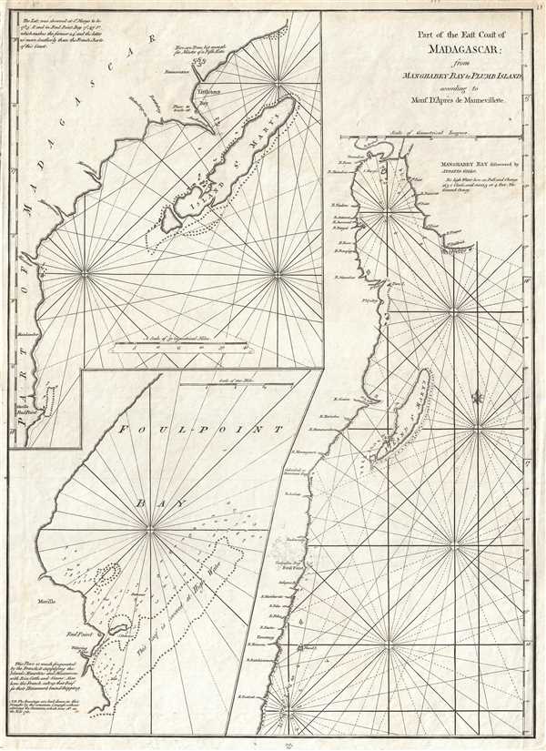
Part of the East Coast of Madagascar from Manghabey Bay to Plumb Island according to Mons. D'Apres de Mannevillette.
1779 (undated) 23 x 17 in (58.42 x 43.18 cm) 1 : 260000
1779 (undated) 23 x 17 in (58.42 x 43.18 cm) 1 : 260000
Description
One of the most enjoyable maps we have had the privilege of cataloging, this is William Herbert's map of the island of Île Sainte-Marie, St. Mary's Island, or as it is known today, Nosy Boraha, Madagascar. During the 17th and 18th centuries Île Sainte-Marie became a base for some of the world's most notorious pirates. Legendary pirates like Adam, Baldridge, William Kidd, Robert Culliford, Olivier Levasseur, Henry Every, Abraham Samuel and Thomas Tew, lived in the île aux Forbans, an island located in the bay of Sainte Marie's main town, Ambodifotatra, here identified simply as 'The Port.' The island was ideally situated for Indian Ocean piracy as it was not far from the maritime routes along which ships returning from the East Indies sailed in transit, their holds overflowing with wealth. The site also offered sheltered bays and inlets, abundant food, and a welcoming indigenous population. Many of these famous pirates would go on to marry local women and found dynasties that prosper on the island to this day. Some believe that this community was the legendary pirate republic of Libertalia, though this is impossible to prove. In 2013 a team under Barry Clifford discovered several 18th century ships scuttled in Île Sainte-Marie's harbor, roughly where the small anchor is on this map, and evidence suggests that at least one of them is most likely William Kidd's infamous pirate galley, the Adventure.
This map was issued by William Herbert to accompany his 1779 New Directory of the East Indies. It is apparently based on the mappings of the French explorer and hydrographer Jean Baptiste Nicolas Denis d' Après de Mannevillette, but no comparable Mannevillette charts are known. The directory itself references numerous charts, including the present map, but all were issued independently and none were published in the book itself. Consequently, the 39 charts identified in the directory's catalog, are all extremely scarce and nearly unobtainable.
This map was issued by William Herbert to accompany his 1779 New Directory of the East Indies. It is apparently based on the mappings of the French explorer and hydrographer Jean Baptiste Nicolas Denis d' Après de Mannevillette, but no comparable Mannevillette charts are known. The directory itself references numerous charts, including the present map, but all were issued independently and none were published in the book itself. Consequently, the 39 charts identified in the directory's catalog, are all extremely scarce and nearly unobtainable.
CartographerS
William Herbert (November 29, 1718 – March 18, 1795) was a British map seller, book seller, publisher, and surveyor based in London in the second half of the 18th century. Herbert was born in London, the son of a dyer and hosier of Gravel Lane. He signed on to the East India company in 1738 as a purser's clerk, traveling in the process to the colonies in India. He returned to London in about 1745, having amassed a considerable collection of manuscript plans and charts of East India ports. Recognizing their commercial value, he set up business as a map and print seller on London Bridge in 1748. The premises of this business were sadly destroyed while Herbed watched the April 11, 1759 London Fire. He published a number of maps as well as the important New Directory for the East Indies. Much of his most important cartographic work seem to be associated with William Nichelson, who traveled to the East Indies in the 1750s and 60s mapping ports on behalf of the EOC. He retired in 1776 in reasonable comfort. His publications continued to be updated and re-published by his successors, among them Samuel Dunn and Henry Gregory. More by this mapmaker...
Jean-Baptiste Nicolas Denis d'Après de Mannevillette (February 11, 1707 - March 1, 1780) was a French sailor, navigator, and hydrographer active in the mid-18th century. Mannevillette was born in Le Havre to a family of wealthy seafarers. He completed his first major voyage at 12, when he accompanied his father, Jean-Baptiste-Claude d'Après de Blangy, a captain of the Compagnie des Indes (French East India Company) vessel Solide to Bengal. On his return to France, he he studied mathematics and navigation in Paris under Joseph Nicholas De L'Isle (1688 - 1768) before returning to the sea at 19 as a fourth officer as on the merchant vessel Marechel d'Estrees. Mannevillette himself eventually attained the rank of Captain with the Compagnie des Indes. In the course of numerous voyages around Africa to India and China, Mannevillette collected and revised numerous nautical charts. His sophisticated use of the most modern instruments, most specifically the Octant or English Quarter, and keen mathematical mind, enabled Mannevillette to correct many significant errors common to earlier maps. These updates were eventually compiled and published in Mannevillette's most significant work, the 1745 Le Neptune Oriental. The 1745 Neptune Oriental was commissioned by the Compagnie des Indes and its production earned Mannevillette admission into the Academy of Sciences. The atlas was well received, but shortly after publication, most unsold examples were destroyed by the French Admiralty, who considered the secrets of East Indian navigation too dangerous for dissemination. In 1762 the Compagnie des Indes appointed Mannevillette director of chart at Lorient. In 1767 King Louis XV conferred the Order of St. Michael upon him and made him an associate of the Royal Marine Academy. In the 30 years following his first publication of Le Neptune Oriental, Mannevillette worked doggedly with his lifelong friend, Alexander Dalrymple (1737 - 1808) to update his original work with new and improved charts. In 1775, he republished his opus in a greatly expanded format - by this time nautical information was less tightly guarded. Mannevillette died on March 1, 1780 at 75 years of age. Learn More...
Source
Herbert, William, New Directory for East Indies, (London: Samuel Dunn) 1779.
Condition
Very good condition. Minor water stain, upper right. Blank on verso. Margin wear. Else clean.
References
OCLC 431367551.