This item has been sold, but you can get on the Waitlist to be notified if another example becomes available, or purchase a digital scan.
1887 Charles Smith Pictorial Map of London
IllustratedLondon-charlessmith-1887$225.00

Title
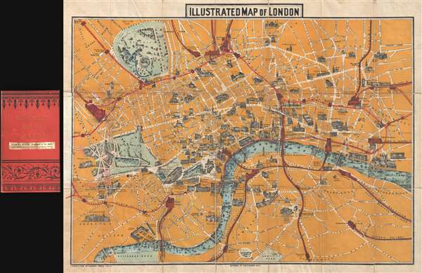
Illustrated Map of London.
1887 (undated) 20 x 26 in (50.8 x 66.04 cm) 1 : 16000
1887 (undated) 20 x 26 in (50.8 x 66.04 cm) 1 : 16000
Description
An uncommon 1887 pictorial map of London by Charles Smith and Son. Centered on the Royal Courts of Justice, the map extends from Kensington Palace to the Tower of London and from Islington Green to Kennington Oval and Park. London's developing transportation network is highlighted in red. Important monuments and even parks are highlighted with vignette illustrations of the buildings themselves.
The Map in Context
Stylistically, the map is modeled after similar maps of Paris that were issued in the late 19th to the early 20th century for the 'Grand Tour' tourist market. They were intended both to promote the city's wonder and be a useful tool to get around and navigate the train system. We have rarely seen maps of the same style illustrating London.History of the Map
The present map was first issued by Charles Smith and in 1867 and went through at least 8 iterations. The earliest versions of this map were monochrome, as color printing had not yet become readily available for mass market productions. At least 7 subsequent editions followed, each offering minor updates to the content reflecting the construction boom London was then experiencing. The present example, 1887 or the 7th state, is one of the first editions to employ a striking full four-color printing process. It also extends the scope of the map east of the Tower of London to include most of Whitechapel.Cartographer
Charles Smith (1768 - 1854) was 19th century British publisher of maps, atlases, and charts, most of which focused on England and London. Smith was appointed map seller to the Prince of Wales in 1809. His early work stylistically resembles the work of Pinkerton, Cary, and Thomson, though on a much smaller scale. From 1826 to 1854 the business traded as Charles Smith and Son. After Charles Smith's death in 1852 the it was taken over by his son William Smith, and later his grandson Guildford Smith (1838 - 1917), who continued to publish maps well into the 20th century. The younger Smith is best known for his introduction of the 'Tape Indicator Map'. This map, which came with a tape measure, enabled users to triangulate their location based coordinates given in an attached guide. The firm was taken over by George Philip in 1916. More by this mapmaker...
Condition
Very good. Minor wear on original fold lines. Minor damage where attached to binder. Accompanies original binder.
References
OCLC 54430307. Hyde, Ralph, Printed Maps of Victorian London, 1851 - 1900, #115 (7).