This item has been sold, but you can get on the Waitlist to be notified if another example becomes available, or purchase a digital scan.
1671 Danckerts / De Wit Travelers' Road Map of the Holy Roman Empire
ImperialRoads-danckerts-1671$425.00

Title
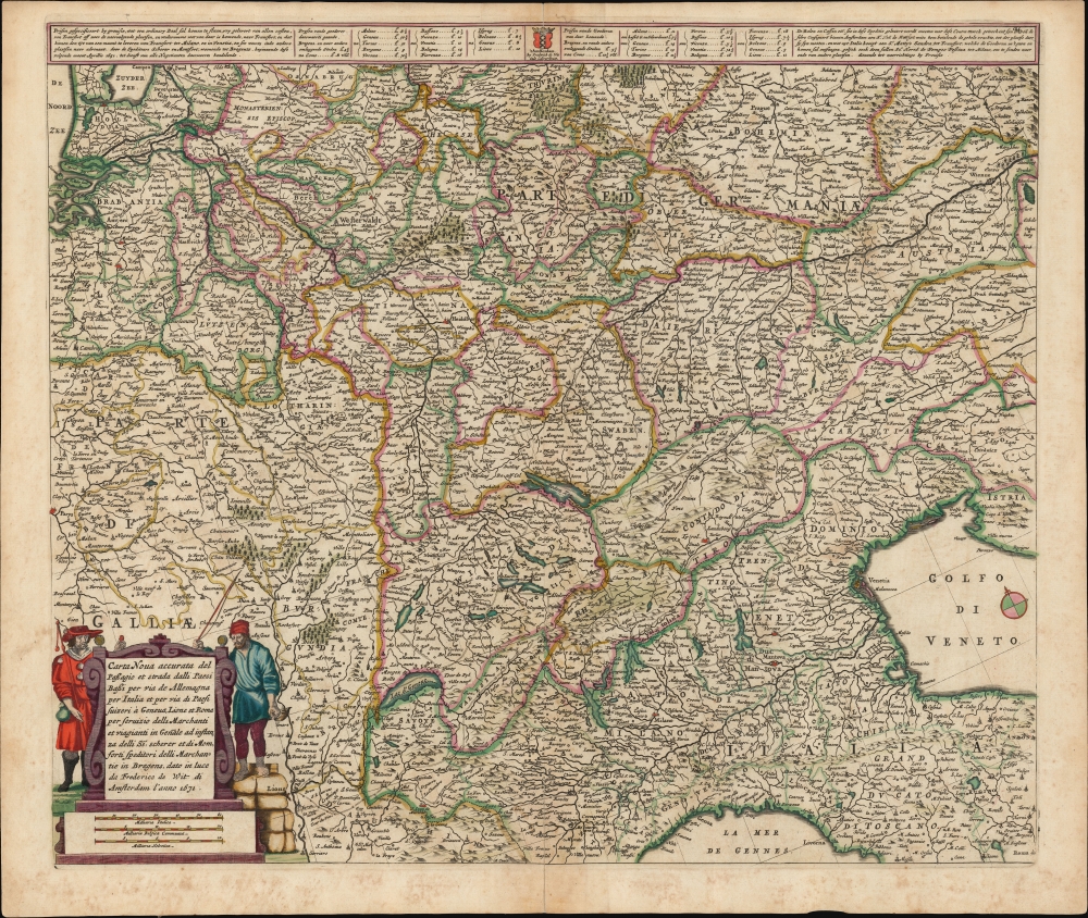
Carta Noua accurata del Passagio et strada dalli Paesi Bassi per via de Allemagna per Italia et per via di Paesi svizeri à Geneva, Lione et Roma per servizio delli Marchanti et viagianti in Genāle ad instanza delli Ss. scherer et sdi Momforti speditori delli Marchantie in Bregens. Dato in luce da Frederico de Wit di Amsterdam l'anno 1671.
1671 (dated) 18.25 x 21.25 in (46.355 x 53.975 cm) 1 : 2250000
1671 (dated) 18.25 x 21.25 in (46.355 x 53.975 cm) 1 : 2250000
Description
This is a scarce road map engraved by Cornelis Danckerts in 1651, embellished and completed by Frederic De Wit for its most attractive edition, printed in 1671. It illustrates the land routes throughout the Holy Roman Empire connecting the Netherlands, France, Germany, Italy, Switzerland, Austria and Bohemia. It is a remarkable instance of a map commissioned by a specific mercantile concern, in this case the shippers Scherer and Montefort of Bregenz, on the Boden Zee in modern-day Austria. Maps depicting roads, particularly at this level of detail and at this scale, are unusual for this period; this one provides a unique glimpse on the business of transporting goods, and of travel in general, in the seventeenth century.
The scallop shell was an icon specifically used by pilgrims en route to Santiago de Compostela, but De Wit here is likely applying the symbology to all pilgrims, Saint James being the patron saint of pilgrims. Indeed, since Saint James was also patron for travelers in general, the image of the Compostela pilgrim here could be read very universally referring to 'the brotherhood of the road.'
A Commercial Map
Danckerts' map was intended to show the routes, via the roads of Germany and Switzerland, connecting the Netherlands to Geneva, Lyon, and Rome 'for the use of merchants and general travelers, at the request of Messrs. Scherer and Montefort, merchant shippers in Bregenz.' It was commissioned by the Bregenz shippers as an advertisement for their April 1651 shipping rates. The work includes those rates between the major cities, and specifies consignment procedures. The intended audience for the map was broad if specifically mercantile. While most textual content and shipping instructions are in Dutch, the cartouche is in Italian: thus both extremes of the route are covered.The Content
The map's unusual orientation to the north-northeast was chosen to allow the mapmaker to fit the desired routes at the largest scale that could be printed to a single folio sheet. This embraces the longest stretch from Amsterdam at the upper left, to Rome in the extreme lower right. Near the center, at the south end of the Boden Zee, is Bergenz, the Swabian town in which the shippers Scherer and Montfort were established. Their position placed them at a potential hub of the roads networking the Holy Roman Empire. The roads can be seen reaching east to Vienna, west to Lyon, and north to Antwerp and Amsterdam. The southern limit to the roads depicted is actually not Rome, but Parma; this likely represented not the absence of roads to the south overall, but the limit of Imperial roads.Travelers of Early Modern Europe
The present state of the map (state four) is the first to feature the completed decorative cartouche. In all earlier issues, the cartouche was unadorned, although it contained identical text to the present example, with the difference that it contained the imprint not of De Wit, but of Danckerts. In the present 1671 state, the cartouche is flanked by two figures representing the typical travelers. On the right, the humbly-dressed man standing atop bales of cargo is a waggoneer, his trade marked by horn and his coachman's whip. To the left, a man wears scallop shell emblems, carries a staff, wears a broad hat, and has a calabash on his belt - the emblems of a pilgrim. This was no passing fashion: dating back to the middle ages, no fewer than four Popes specified the required elements of pilgrim's dress. Not only were these practical (carry water, wear a broad hat against the sun, bring a staff for support and defense), but it was also important for pilgrims to mark their religious undertaking, and thus avoid being mistaken for highwaymen.The scallop shell was an icon specifically used by pilgrims en route to Santiago de Compostela, but De Wit here is likely applying the symbology to all pilgrims, Saint James being the patron saint of pilgrims. Indeed, since Saint James was also patron for travelers in general, the image of the Compostela pilgrim here could be read very universally referring to 'the brotherhood of the road.'
The Most Complete Version Geographically
In addition to the fine cartouche, De Wit's 1671 issue of the map is the most 'finished' variant. Earlier states lacked many cities included here, especially points in Italy south of the Po River, and in France south of the Seine. De Wit's map also adds topographical elements lacking in earlier issues. The goal was to refine a specially-ordered map with a narrow audience, to make it more consistent De Wit's widely commercial atlas maps. De Wit likely acquired the copperplate at auction following 1666 death of Dancker Danckerts. He began adding it to his atlases immediately, removing the Danckerts imprint and adding that of his own shop on the Calverstraet.Publication History and Census
The map was engraved by Cornelis Danckerts no later than March of 1651. The states of the map we identify are as follows:- (1651) Top center under the Amsterdam arms, ''t Amsterdam, by Corn. Danckertz.'; imprint in cartouche reads 'dato in luce da Cornelio Dancherts di Amsterdam l'anno 1651.'
- (1661) In cartouche, 'Dancker Danckerts excudit is added.
- (1666) cartouche retains Cornelis' imprint; Dancker's imprint is removed. At top center, Danckert's imprint is replaced with 'by Frederick de Wit inde Calverstraet.'
- (1671) Figures added to cartouche, Danckert's imprint replaced with De Wit's, and the date changed to 1671.
- (c. 1720) Covens and Mortier acquire and alter the plate further; the price and advertising matter at top are replaced with French and Dutch titles, and the cartouche text is altered to replace references to Scherer and Montfort with the Covens and Mortier imprint.
CartographerS
Frederik de Wit (1629 - 1706) was a Dutch Golden Age cartographer active in the second half of the 17th and the early 18th centuries. De Wit was born of middle class Protestant stock in the western Netherlandish town of Gouda. He relocated to Amsterdam sometime before 1648, where he worked under Willem Blaeu. His first attributed engraved map, a plan of Haarlem for Antonius Sanderus' Flandria Illustrata, was issued around this time. He struck out on his own in 1654. The first chart that De Wit personally both drew and engraved was most likely his 1659 map of Denmark, REGNI DANIÆ Accuratissima delineatio Perfeckte Kaerte van ‘t CONJNCKRYCK DENEMARCKEN. His great wall map of the world and most famous work, Nova Totius Terrarum Orbis Tabula appeared one year later. Following the publication of his wall map De Wit quickly rose in prominence as a both cartographer and engraver. He married Maria van der Way in 1661 and through her became a citizen of Amsterdam in 1662. Around this time he also published his first major atlas, a composite production ranging in size from 17 to over 150 maps and charts. Other atlases and individual maps followed. In 1689 De Wit was granted a 15 year Privilege by the Dutch States General. (An early copyright that protected the recipient's rights to print and publish.) He was recognized with the honorific 'Good Citizen' in 1694. De Wit died in 1706 after which his wife Maria continued publishing his maps until about 1710. De Wit's son, Franciscus, had no interest in the map trade, instead choosing to prosper as a stockfish merchant. On her own retirement, Maria sold most De Wit maps and plates at a public auction. Most were acquired by Pieter Mortier and laid the groundwork for the 1721 rise of Covens and Mortier, the largest Dutch cartographic publishing house of the 18th century. More by this mapmaker...
The Danckerts family (fl. 1628 - 1717) were a Dutch engraving and cartographic publishing firm active in Amsterdam during the latter half of the 17th and early 18th centuries. The firm was founded by Cornelis Dankerts II (1603-1656) and his brother Dancker Danckerts (1614-16?). Cornelius and Dancker published few maps, but did pass the business on to Cornelius' son Justus Danckerts (1635 - 1701) and grandsons Theodorus Danckerts (1663-1727) and Cornelius Danckerts III (1664-1717). The firm was most active in this period between 1680 and 1700 when a number of atlases and maps appeared bearing either the Justus Danckerts or Theodorus Danckerts imprint. At the time, it was in vogue in Amsterdam to leave maps undated, which makes Danckerts maps particularly difficult to ascribe. Similarly, there is a considerable corpus of maps signed as Cornelius Danckerts. When dated we can correctly attribute these to either Cornelius II or Cornelius III, though, typically, most are undated and consequently difficult to attach to the correct Danckerts family member. The Danckerts family is well known for its highly detailed and graphic engraving style. In addition to numerous atlas maps, they also produced a number of spectacular Dutch wall maps. In the early 18th century, the Danckerts map plates were purchased by R. and J. Ottens, who reprinted many of them under their own imprint. (Ref: Keuning, J., "Cornelis Danckerts and his "Niew Aerdsh Pleyn"", Imago Mundi, Vol. 12 (1955), pp. 136-139.) Learn More...
Condition
Very good. Mended centerfold splits at top and bottom with some scuffing; few filled wormholes. Else an attractive, full-margined example with fine original color.
References
OCLC 1055767582.