1725 Homann Map of the Turkish Empire
ImperiumTurcicum-homann-1725$850.00

Title
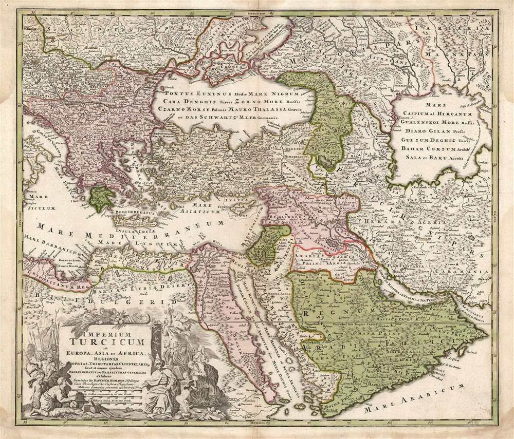
Imperium Turcicum in Europa, Asia et Africa, Regiones Proprias, Tributarias, Clientelares et Sicut et Omnes Praefecturas Generales exhibens.
1725 (undated) 19 x 22 in (48.26 x 55.88 cm) 1 : 10400000
1725 (undated) 19 x 22 in (48.26 x 55.88 cm) 1 : 10400000
Description
This is a handsome example of the J. B. Homann 1725 map of the Turkish Empire in Europe, Asia and Africa. It shows the extent of the Ottoman Empire encompassing \the Arabian Peninsula, as well as the coastal parts of the empire in North Africa and Egypt. The border with the Persia is shown in the east, along with a considerable part of what is today Iran and Central Asia. The empire's contentious border in Europe, abutting Hungary, Transylvania, and Poland, is also shown. The area north of the Black Sea shows both Tatar territories and those of Muscovy on the Turkish frontier.
The present example is (absent the discovery of further states) the second, with the erased Steinberger imprint.
A Polemical Cartouche
The cartouche, staged around a massive plinth bearing the map's title and scales, portrays the Turkish Empire in a blatantly negative light: unsurprising given the map's 18th century, Catholic source, and the long history of war between the west and east. Seated to the right of the plinth is the Ottoman Sultan; incense burners are set around him, and he treads a crucifix underfoot. Behind him, his courtiers make obeisance. In the background, a horned and winged figure presents a group of Ottomans with a turbaned statue - meant to be an idol representing Mohammed, showing a gross misunderstanding, as well as a blasphemous denigration of the role of the Prophet in Islam. On the other side of the cartouche, a crowd of Turkish soldiers drive forward two miserable prisoners to grovel before the Sultan (whose hand gestures them down.)Cantelli's Corrections Apparent
Most maps of the eastern parts of this region produced in the 16th and 17th centuries followed the model of Claudius Ptolemy in showing the Caspian Sea as oval-shaped, widest on its east-west axis with the ancient Oxus, or Amu Darya river, flowing into its southeast quarter. The first map to correct this was that of Adam Olearius (1603 - 1671), whose 1647 map much more accurately mapped the Caspian's western shore, and was first to diverge from the Ptolemaic oval form. Cantelli's 1679 map of the Persian Empire adopted Olearius, suggesting the eastern extent of the Caspian as shown here may actually be the shores of the Aral Sea. The Turkic tribal population surrounding the Caspian and Aral regions were notoriously aggressive to outsiders, and Europeans would remain ignorant of the true form of the Caspian until well into the 18th century. It is very possible that the early, wide depiction of the Caspian represented a conflation of the Caspian and the Aral Seas.The Persian Gulf
The terminology for the Persian Gulf used here - 'Golfo di Bassora' and 'Golfo d'Elcatif' - also betrays this region's source as the Italian Cantelli; likewise the naming of Bahrain both a city on the mainland, 'Bahruin,' and an island, 'Baeren I.' Cantelli's influence can also be seen in Homann's depiction of the Maeotian Swamp north of the Black Sea (this also appeared in earlier maps, for example those of Sanson, but the shape here reveals Cantelli as the source.)Publication History and Census
We identify several different versions of this map. One, as early as 1702 but probably closer to 1714 lacks the Imperial privilege, and bears the imprint in the cartouche of the engraver, J. C. Steinberger. It is notable geographically for its enlarged Caspian Sea, following the Cantelli model. A further state of this plate, at a minimum, exists, probably printed between 1725 and 1730 after the death of Homann but before the establishment of Homann's Heirs. It shows reengraving, particularly of the cartouche, to the extent of the erasure of the Steinberger imprint (traces of which can be seen.) In 1737 Homann Heirs engraved an entirely new plate, using the same title (including the imprint of the elder Homann, who never lived to see the map.) While the elements within the cartouche are the same, the execution of them is quite different; geographically, the map is entirely new, being derived from the work of De l'Isle and J. M. Hase. It is dated '1737' in the upper margin.The present example is (absent the discovery of further states) the second, with the erased Steinberger imprint.
Cartographer
Johann Baptist Homann (March 20, 1664 - July 1, 1724) was the most prominent and prolific map publisher of the 18th century. Homann was born in Oberkammlach, a small town near Kammlach, Bavaria, Germany. As a young man, Homann studied in a Jesuit school and nursed ambitions of becoming a Dominican priest. Nonetheless, he converted to Protestantism in 1687, when he was 23. It is not clear where he mastered engraving, but we believe it may have been in Amsterdam. Homann's earliest work we have identified is about 1689, and already exhibits a high degree of mastery. Around 1691, Homann moved to Nuremberg and registered as a notary. By this time, he was already making maps, and very good ones at that. He produced a map of the environs of Nürnberg in 1691/92, which suggests he was already a master engraver. Around 1693, Homann briefly relocated to Vienna, where he lived and studied printing and copper plate engraving until 1695. Until 1702, he worked in Nuremberg in the map trade under Jacob von Sandrart (1630 - 1708) and then David Funck (1642 - 1709). Afterward, he returned to Nuremberg, where, in 1702, he founded the commercial publishing firm that would bear his name. In the next five years, Homann produced hundreds of maps and developed a distinctive style characterized by heavy, detailed engraving, elaborate allegorical cartouche work, and vivid hand color. Due to the lower cost of printing in Germany, the Homann firm could undercut the dominant French and Dutch publishing houses while matching their diversity and quality. Despite copious output, Homann did not release his first major atlas until the 33-map Neuer Atlas of 1707, followed by a 60-map edition of 1710. By 1715, Homann's rising star caught the attention of the Holy Roman Emperor Charles VI, who appointed him Imperial Cartographer. In the same year, he was also appointed a member of the Royal Academy of Sciences in Berlin. Homann's prestigious title came with several significant advantages, including access to the most up-to-date cartographic information as well as the 'Privilege'. The Privilege was a type of early copyright offered to very few by the Holy Roman Emperor. Though less sophisticated than modern copyright legislation, the Privilege offered limited protection for several years. Most all J. B. Homann maps printed between 1715 and 1730 bear the inscription 'Cum Priviligio' or some variation. Following Homann's death in 1724, the firm's map plates and management passed to his son, Johann Christoph Homann (1703 - 1730). J. C. Homann, perhaps realizing that he would not long survive his father, stipulated in his will that the company would be inherited by his two head managers, Johann Georg Ebersberger (1695 - 1760) and Johann Michael Franz (1700 - 1761), and that it would publish only under the name 'Homann Heirs'. This designation, in various forms (Homannsche Heirs, Heritiers de Homann, Lat Homannianos Herod, Homannschen Erben, etc.) appears on maps from about 1731 onwards. The firm continued to publish maps in ever-diminishing quantities until the death of its last owner, Christoph Franz Fembo (1781 - 1848). More by this mapmaker...
Source
Homann, J. B. and Homann, J. C., Neuer Atlas bestehend in einig curieusen Astronomischen Kuppren und vielen auserlesenen accuratensten Land-Charten über die Gantze Welt, (Nuremberg: Homann), 1728.
Homann's Neuer Atlas bestehend in einig curieusen Astronomischen Kuppren und vielen auserlesenen accuratensten Land-Charten über die Gantze Welt was first publihsed in 1707 with 33 maps. A second edition followed in 1710 with 60 maps. Subsequent editions followed until about 1730. The title page notes proudly that the atlas features measurements based on the 'Copernican principle of the moving sky', a truly state-of-the-art innovation for the period. Regardless of editions, collations of the atlas are inconsistent, with some examples having less, while others have more maps - a consequence of the fact that the map sheets were delivered loose, to be bound at the buyer's discretion, and so some buyers chose to omit maps they did not consider relevant, or add others they did. Between editions, the constituent maps, particularly of European regions, were regularly updated to reflect the most recent political events. The atlas continued to be published by Homann's son, J. C. Homann (1703 - 1730), and then by Homann Heirs. Most examples also feature a fine allegorical frontispiece with the title Atlas Novus Terrarum Orbis Imperia, regna et Status, which was used for multiple Homann atlases, including the Neuer Atlas and the Atlas Minor.
Condition
Very good. Some toning and waterstaining to margins. Fine original color.
References
OCLC 21791307. Rumsey 12499.202 (first state).