This item has been sold, but you can get on the Waitlist to be notified if another example becomes available, or purchase a digital scan.
1796 Carey Map of India
India-carey-1796$200.00

Title
Map of Hindostan or India.
1796 (undated) 16 x 17 in (40.64 x 43.18 cm) 1 : 10264320
1796 (undated) 16 x 17 in (40.64 x 43.18 cm) 1 : 10264320
Description
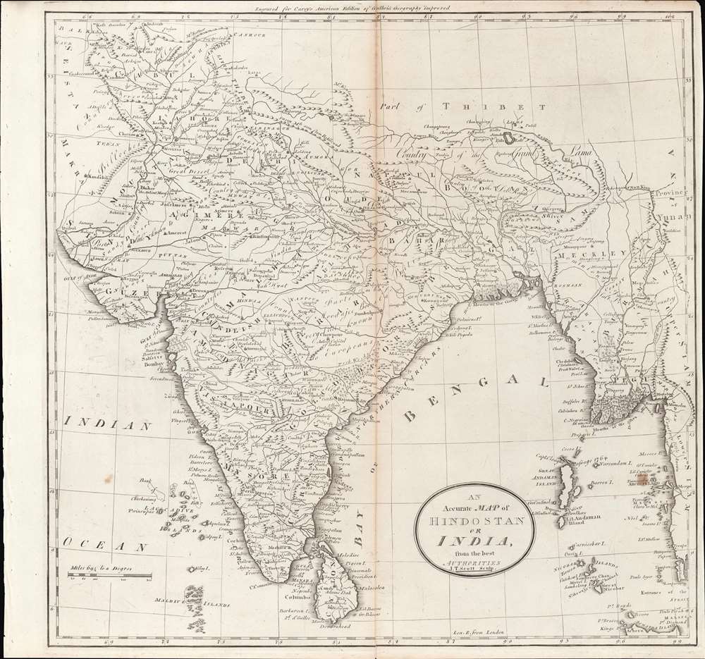
This is a rare c. 1796 map of South Asia from Carey's General Atlas, the first atlas published in the new American Republic. It shows the Indian subcontinent at a period of rapid transition towards the hegemony of the British East India Company (EIC).
The map does not show political divisions, which were maddeningly complex given the various confederations, alliances, and protectorates of the time, but does mention local rulers and states, such as 'Moodajee Boosla' (ruler of Berar) and 'Hoklar and Sindia,' important players in the Maratha Confederation. Notes point to areas 'very little known to Europeans' as well as other areas of note, such as the 'Heads of the Ganges and Burrampooter [Brahmaputra] or Sanpoo Rivers.'
Soon after this map was made, the EIC would rapidly gain control (directly or indirectly) over much of southern India, mostly at the expense of the Maratha Confederacy, which itself had greatly weakened and largely replaced the once-mighty Mughal Empire. In the north, what remained of the Mughal Empire was also pressed from the north by the Afghan Durrani Empire and the Sikhs. Other kingdoms such as Mysore and Hyderabad also were major factors in the contest for control of the Indian subcontinent.
Although initially just one actor among many, the British profited tremendously from this complicated political landscape and increasingly became interested in territorial annexation. By the 1830s, British ambitions turned towards northern India, where the industrialized military might of the company's forces allowed it to gain control in a short period of time. However, the company's growing power provoked resentments which became clear in the 1857 Mutiny and the dissolution of the EIC the following year.
A Closer Look
The map covers the entire Indian subcontinent as well as portions of Afghanistan, the Himalayas, and Burma. At far right are the borders of China and Siam, and at far left are Seistan (Sistan) and Makran, territories on the frontiers between India, Persia, and Afghanistan. As with many European maps of this era, small islands in the Maldive, Laccadive, Andaman, and Nicobar Island chains are exaggerated in size, likely due to their importance for navigators.The map does not show political divisions, which were maddeningly complex given the various confederations, alliances, and protectorates of the time, but does mention local rulers and states, such as 'Moodajee Boosla' (ruler of Berar) and 'Hoklar and Sindia,' important players in the Maratha Confederation. Notes point to areas 'very little known to Europeans' as well as other areas of note, such as the 'Heads of the Ganges and Burrampooter [Brahmaputra] or Sanpoo Rivers.'
Company Rule in India
Until the mid-18th century, the British East India Company (EIC) was like the East India Companies of other European powers in that it mostly operated in coastal ports and did not seek to control large portions of territory. That changed when the company expanded its interests in Bengal from a 'factory' (trading post) to gaining the right to collect taxes, followed by de facto and eventually de jure rule over Bengal and Bihar. The Battle of Plassey in 1757, an oft-forgotten turning point in world history, gave the British the upper-hand over their competitors in India (particularly the French) and set a precedent of exploiting tensions between local Indian states to expand the domains of the EIC.Soon after this map was made, the EIC would rapidly gain control (directly or indirectly) over much of southern India, mostly at the expense of the Maratha Confederacy, which itself had greatly weakened and largely replaced the once-mighty Mughal Empire. In the north, what remained of the Mughal Empire was also pressed from the north by the Afghan Durrani Empire and the Sikhs. Other kingdoms such as Mysore and Hyderabad also were major factors in the contest for control of the Indian subcontinent.
Although initially just one actor among many, the British profited tremendously from this complicated political landscape and increasingly became interested in territorial annexation. By the 1830s, British ambitions turned towards northern India, where the industrialized military might of the company's forces allowed it to gain control in a short period of time. However, the company's growing power provoked resentments which became clear in the 1857 Mutiny and the dissolution of the EIC the following year.
India and America
The context of the new American Republic in which Carey's Atlas was published had important connections with developments in India. To begin with, the Boston Tea Party was motivated primarily by special privileges (tax exemptions) granted to the EIC that were not available to American traders. Moreover, Britain was forced to eventually grant independence to its American colonies in part because of its need to focus on a growing worldwide conflict with the French, including in India. American independence also caused a shift in British imperial strategy, often seen as the start of the 'Second British Empire,' that was more focused on Asia, including India.Publication History and Census
This map is likely from an early edition of Carey's General Atlas (sometimes subtitled American Edition of Guthrie's Geography improved), multiple editions of which were printed between 1795 and 1818. The present map is from the 1796 edition.CartographerS
Matthew Carey (January 28, 1760 - September 16, 1839) was a Dublin born publisher who established himself in Philadelphia in the late 18th and early 19th century. A young man of socially progressive views, Carey's first known publication, produced when he was but 17 years old, was a pamphlet criticizing dueling. Another pamphlet, issued in the same year, attacked the Irish penal code. Shortly afterwards, in 1779, legal issues, possibly arising from his liberal political activism, forced Carey to flee to Paris. In Paris, Carey had the good fortune to befriend the visiting American diplomat and founding father, Benjamin Franklin (1706 - 1790). As an Irishman chafing under the rule of England, Carey sympathized with and admired the American revolutionary. The liberally minded pair struck up a lifelong friendship and Carey was hired to work at Franklin's press in Passy, France. A year later, Carey returned to Ireland and resumed his politically provocative publishing career with The Freemans's Journal and The Volunteer's Journal. It didn't take long for political pressure to once again force Carey from Ireland - this time to America (1784). Although largely without funds, Carey convinced Gilbert du Motier, Marquis de Lafayette (1757 - 1834), who he knew from Franklin's Paris circle, to lend him funds to establish a new publishing concern in Philadelphia. Despite this loan, Carey's firm remained under financed and opened on a shoestring budget. It was most likely his limited budget that led Carey to some of his most important publishing innovations. At the time cartographic publishing was dominated by large printing houses in London and Paris where most, if not all, of the work was completed in house. Without the finances to emulate this large publishing houses, Carey was forced to outsource much of his publishing work. This set the stage for subsequent American publishers who, in order to compete effectively with European firms, relied on an often bewildering network of alliances and collaborations. Carey was also a master of republishing many of his own maps in multiple different atlases and formats to maximize their profitability. His most important work is without a doubt the 1795 issue of the American Atlas the first atlas to be published in America. Carey died in 1839 but was succeeded by his son Henry Charles Carey (1793 - 1879) who, in partnership with his brother-in-law Isaac Lea (1792 - 1886), published numerous important maps and atlases under the Carey and Lea, Lea Brothers, and Lea and Blanchard imprints. More by this mapmaker...
William Guthrie (1708 - March 9, 1770) was a Scottish historian, journalist, and writer. Born in Brechin, he studied at Aberdeen University with the idea of becoming a parochial schoolmaster. Instead, in 1730, he elected to settle in London and try his hand at literature. He covered parliamentary debates f or the Gentleman's Magazine and soon earned a reputation for being a political writer. He published several scholarly works, including a History of England from the Invasion of Julius Caesar to 1688 in four volumes, and, most notably, his Geographical Historical, and Commercial Grammar. Learn More...
Source
Carey, M., Carey's General Atlas, (Philadelphia: Carey) 1796.
Condition
Good. Central fold line visible. Some wear along fold line and edges.
References
Rumsey P683-21.