This item has been sold, but you can get on the Waitlist to be notified if another example becomes available, or purchase a digital scan.
1692 / 1696 Coronelli Map of India
India-coronelli-1692$375.00

Title
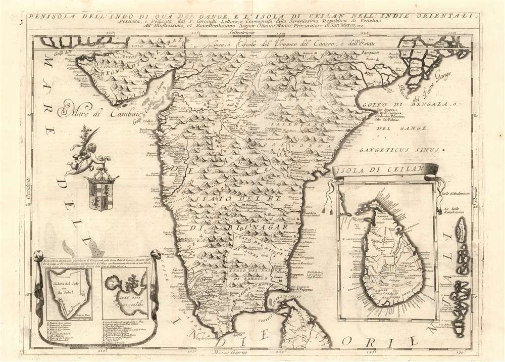
Penisola dell'Indo di qua del Gange, e L'Isola di Ceilan Nell'Indie Orientali.
1692 (undated) 17.75 x 24 in (45.085 x 60.96 cm) 1 : 4600000
1692 (undated) 17.75 x 24 in (45.085 x 60.96 cm) 1 : 4600000
Description
This is Vincenzo Maria Coronelli's large 1692 map of the Indian peninsula, presenting detail not appearing on any prior map.. Many of Coronelli's maps, even most of them, were derived from his globes - notably his 1688 42-inch terrestrial globe. However, the details here do not refer to his printed gores. Coronelli intended his initial atlases - his Atlante Veneto and Corso Geografico Universale - to be extensions of Blaeu's great atlas. Thus it makes sense that in the first volume of his work, Coronelli focused on peninsular India, a region neglected by Blaeu. While Blaeu had produced a map of the Mogul Empire based on the 1619 Baffin map, the full extent of India south of the Moguls was included only in Blaeu's general map of the East Indies. Coronelli was not the only mapmaker after Blaeu to address the region, but he was the first to present it in so grand a format.
Moreover, further to the south in Malabar (inexplicably named 'Regno di Madagascar') there is a meticulously detailed system of rivers with named towns well inland from the coast. Again, this does not appear on any other map of the 17th century, and we have not seen this information reproduced on any since.
...'Pleasing to the Artist's eye'...
Susan Gole sniffs disapprovingly at Coronelli's map: 'Coronelli published two very decorative maps of the subcontinent, which are more pleasing to the artist's eye than the geographer's...' and indeed the map, as is typical of the work of Coronelli's shop, is beautifully engraved. The coastline of the peninsula recognizably follows the late 16t century cartography of Linschoten. The interior topography differs sharply from the Dutch model: where Dutch maps placed a sharp spine of mountains neatly bisecting the Peninsula, Coronelli follows Sanson and Cantelli in scattering mountains more liberally. The size, number, and pictorial quality of the mountains seems to disguise the paucity of fine interior detail.A Neglected Map with Surprising Detail
We do not agree with Gole's disappointment. The entire west coast of the map, and areas just inland, show features which do not appear on any earlier printed maps, and very few to follow. In the province of Decan, a string of settlements running inland to the fortress of Visapur is shown, continuing again to the southwest towards Goa. The appearance of a close stringing of named cities, such as this, indicates a specific travelers' report. This instance does not appear on any earlier map, and it does not appear on Coronelli's other printed maps or globes. This strongly suggests the exclusive receipt of fresh information. Its next appearance on a map, to our knowledge, is on the 1719 Guillaume De l'Isle map Carte des Cotes de Malabar et de Coromandel.Moreover, further to the south in Malabar (inexplicably named 'Regno di Madagascar') there is a meticulously detailed system of rivers with named towns well inland from the coast. Again, this does not appear on any other map of the 17th century, and we have not seen this information reproduced on any since.
Sources?
The map includes no direct reference to specific geographical sources, much less for the unique features mentioned above. Manonmani Restif-Filliozat, in her 2019, The Jesuit Contribution to the Geographical Knowledge of India in the Eighteenth Century, explored the neglected field of Jesuit geographers and their transfer of knowledge to De l'Isle and d'Anville but did not reveal similar activity in the seventeenth century. The striking similarities between the Decan coast of Coronelli's map with that on the otherwise dissimilar 1719 De l'Isle suggests a relationship between the cartographers' sources. Coronelli's connections with French Jesuits were very well established and - with respect to the Americas and the Far East, well understood. It is entirely possible that here, too, Coronelli had access to a yet-unidentified Jesuit geographical source. The presence of such unique features suggests further scrutiny may unveil additional singular details. The importance of this map must be reassessed.The Scope and General Content of the Map
Coronelli's map focuses on India south of Guzarat and the mouth of the Ganges, and spanning from the mouth of the Indus River to the Ganges delta. The eastern extreme of the map embraces the Andaman Islands. In the oceans to the left and right are inset detail maps. One depicts the island of Ceylon (Sri Lanka) and the other both the Bay of Trincomalee or Cotiari, and the fortifications on the Isoletta del Sole (since the Second World War known as Great Sober Island). Off the coast, between Goa and Bombay, a putto bears a coat of arms - almost certainly that of the dedicatee, Ottavio Manin. (Manin, the Procurator of St. Mark, was one of the most powerful men in Venice, and Coronelli dedicated several maps to him.)Publication History and Census
The map was engraved for inclusion in Coronelli's 1692 Corso Geografico Universale, and was thereafter included in his Isolario, generally included as part of his Atlante Veneto. There are only seven examples of the separate map listed in OCLC. Coronelli's Isolario is, however, well represented in institutional collections.Cartographer
Vincenzo Maria Coronelli (August 16, 1650 - December 9, 1718) was an important 17th-century cartographer and globe maker based in Venice. Coronelli was born the fifth child of a Venetian tailor. Unlikely to inherit his father's business, he instead apprenticed in Ravenna to a woodcut artist. Around 1663, Coronelli joined the Franciscan Order and, in 1671, entered the Venetian convent of Saint Maria Gloriosa dei Frari. Coronelli excelled in the fields of cosmography, mathematics, and geography. Although his works include the phenomenal Atlante Veneto and Corso Geografico, Coronelli is best known for his globes. In 1678, Coronelli was commissioned to make his first major globes by Ranuccio II Farnese, Duke of Parma. Each superbly engraved globe was five feet in diameter. Louis IV of France, having heard of the magnificent Parma globes, invited Coronelli to Paris, where from 1681-83 he constructed an even more impressive pair of globes measuring over 12 feet in diameter and weighing 2 tons each. The globes earned him the patronage of Louis XIV and privileged access to French cartographic information from Jesuit sources in the New World, particularly Louisiana. Coronelli returned to Venice and continued to publish globes, maps, and atlases, which were admired all over Europe for their beauty, accuracy, and detail. He had a particular fascination for the Great Lakes region, and his early maps of this area were unsurpassed in accuracy for nearly 100 years after their initial publication. He is also well known for his groundbreaking publication of the first accurate map depicting the sources of the Blue Nile. At the height of his career, Coronelli founded the world's first geographical society, the Accademia Cosmografica degli Argonauti, and was awarded the official title Cosmographer of the Republic of Venice. In 1699, in recognition of his extraordinary accomplishment and scholarship, Coronelli was also appointed Father General of the Franciscan Order. The great cartographer and globe maker died in Venice at the age of 68. His extraordinary globes can be seen today at the Bibliothèque Nationale François Mitterrand in Paris, Biblioteca Marciana in Venice, the National Library of Austria, the Globe Museum in Vienna, the Library of Stift Melk, the Special Collections Library of Texas Tech University, as well as lesser works in Trier, Prague, London, and Washington D.C. Coronelli's work is notable for its distinctive style, which is characterized by the high-quality white paper, dark intense impressions, detailed renderings of topographical features in profile, and numerous cartographic innovations. More by this mapmaker...
Source
Coronelli, V., Isolario dell' Atlante Veneto, (Venice: A spese dell' Autore) 1697.
The Isolario dell' Atlante Veneto, also titled Isolario Descrittione Geografico-Historia, is the second part of the Jesuit Minorite friar, geographer, and globe maker Vincenzo Maria Coronelli's multi-volume Atlante Veneto. The Isolario was compiled in Venice and published in 1696-97. The work consists of two parts which, as the title suggests, focus primarily on islands. The first part covers the Mediterranean, Italy, and the Adriatic, while the second part details Britain and Europe, Africa, Japan and Asia, and the West Indies. Like some of his other works, Coronelli published the Isolario 'A spese dell' Autore' [At the Expense of the Author].
Condition
Very good. Faint offsetting, else excellent.
References
OCLC 733642548. Gole,S., Early Maps of India, 23 b. Rumsey 11391.107.