This item has been sold, but you can get on the Waitlist to be notified if another example becomes available, or purchase a digital scan.
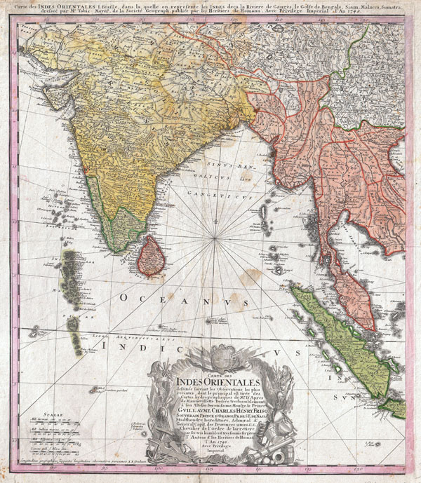
1748 Homann Heirs Map of India and Southeast Asia
India-hmhr-1748$200.00

Title
Carte des Indes orientales I. feuille, dans la quelle on represente les Indes deca la Riviere de Ganges, le Golfe de Bengale, Siam, Malacca, Sumatra dressee par Mr. de Tobie Mayer de la Societe Geograph.
1748 (dated) 20.5 x 17.5 in (52.07 x 44.45 cm)
1748 (dated) 20.5 x 17.5 in (52.07 x 44.45 cm)
Description
An attractive example of the western sheet of the Homann Heirs 1748 map of India and Southeast Asia. Details the subcontinent as well as much of Southeast Asia, including modern day Burma, Thailand, Laos, Malaysia, Singapore and Sumatra. Extends north to include Delhi (Delly) and Agra as well as parts of Tibet. The apocryphal Lake of Chiamay, a cartographic error common in many early maps of this region, appears in vestigial form near Assam. Portuguese Goa is highlighted. Drawn by Tobias Meyer for the Homann Heirs in 1748.
Cartographer
Homann Heirs (1730 - 1848) were a map publishing house based in Nuremberg, Germany, in the middle to late 18th century. After the great mapmaker Johann Baptist Homann's (1664 - 1724) death, management of the firm passed to his son Johann Christoph Homann (1703 - 1730). J. C. Homann, perhaps realizing that he would not long survive his father, stipulated in his will that the company would be inherited by his two head managers, Johann Georg Ebersberger (1695 - 1760) and Johann Michael Franz (1700 - 1761), and that it would publish only under the name 'Homann Heirs'. This designation, in various forms (Homannsche Heirs, Heritiers de Homann, Lat Homannianos Herod, Homannschen Erben, etc..) appears on maps from about 1731 onwards. The firm continued to publish maps in ever diminishing quantities until the death of its last owner, Christoph Franz Fembo (1781 - 1848). More by this mapmaker...
Condition
Good condition. Minor verso repairs along some of the original fold lines. Minor spotting and overall toning. Blank on verso.
References
National Library of Australia, MAP RM 2526.