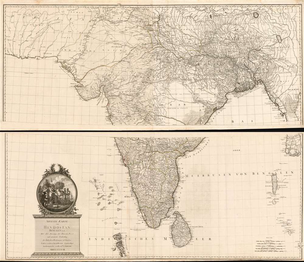
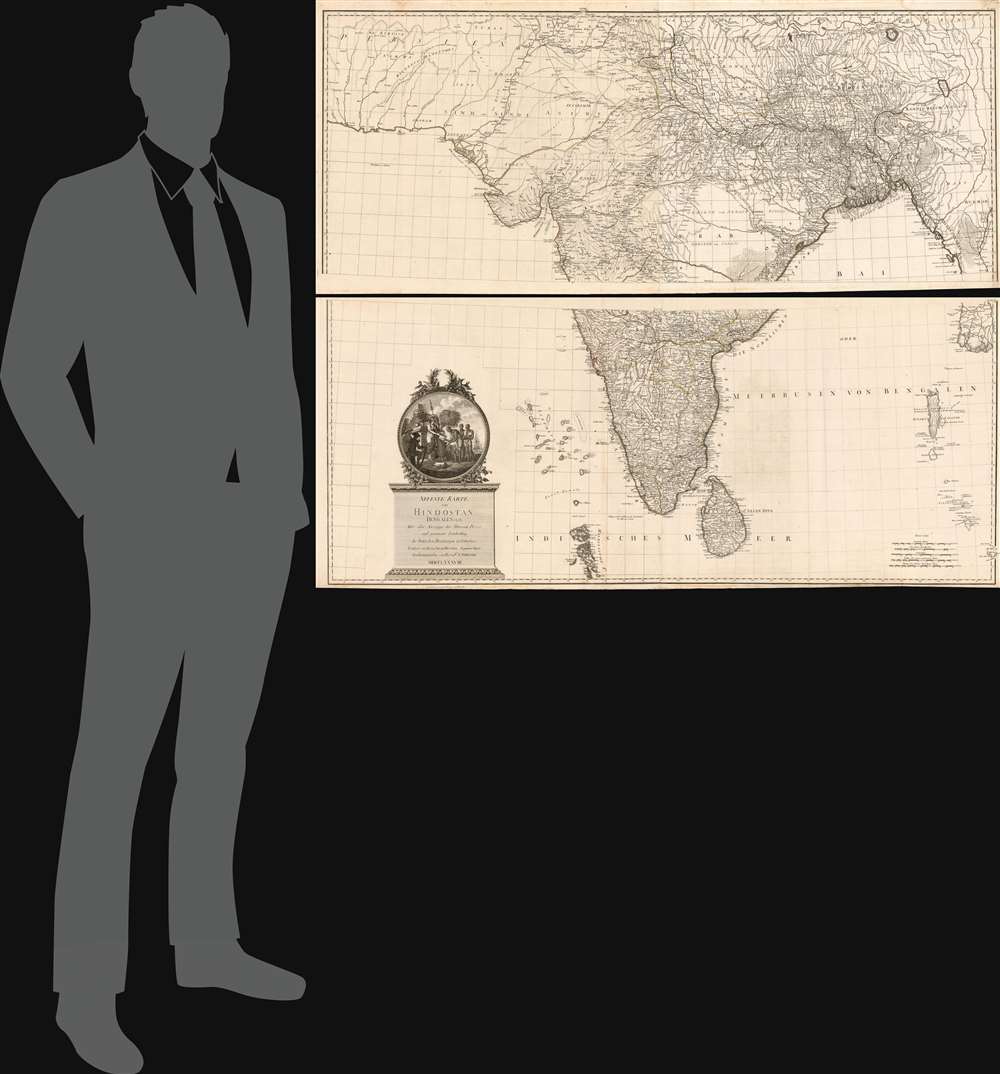
1788 Schräembl / Rennell map of India
India-schraembl-1788$1,000.00

Title
Neueste Karte von Hindostan Bengalen etc. etc. Mit der Anzeige der Strassen, Paesse, und genauester Eintheitung der britischen Besilzungen in Ostindien Verfasst von Herrn Jakob Rennell Ingenieur Major Neu herausgegeben von Herrn F.A. Schraembl. MDCCLXXXVIII.
1788 (dated) 46.75 x 56.25 in (118.745 x 142.875 cm) 1 : 2600000
1788 (dated) 46.75 x 56.25 in (118.745 x 142.875 cm) 1 : 2600000
Description
This is Franz Anton Schrämbl's 1788 map of India. This scarce, magnificently-engraved map is a faithful rendition of James Rennell's masterful 1782 Map of Hindoostan, the finest 18th century map of the subcontinent, capturing the best surveys of India available during the period in which the British East India Company held sway. Rennell's work, based on the first scientific surveys of India, presented the region in a matchless degree of detail. By adopting this map as his source, Schrämbl was choosing the absolute state-of-the-art of India mapping. One of the first Austrian world atlases, Schrämbl's Allgemeiner Grosser Atlas presented the works of the best cartographers of the day: D'Anville, Kitchin, the Berlin Academy of Sciences and the St. Petersburg Academy of Sciences all shared the pages of this monumental work with Rennell.
A Vital Tool of Colonialism
The map produced by the EIC utilized the best techniques of trigonometrical, military, and topological surveying available. The unprecedented detail was much sought after, as rival European powers - at this point, primarily the British and the French - vied over land claims in India, dividing the region and extracting revenue. Maps of this quality were essential not only for military affairs, but also for administration. Rennell's map, which was the first map of India based on physical surveys rather than anecdotes, would have been considered essential.The Cartouche
Schrämbl's map is faithful not only to the cartography but to the iconography as well: the beautiful cartouche is a close copy. With a pedestal of British Victory behind her, a helmeted and armed Britannia is depicted in the process of bestowing upon Hindu Brahmins a book, as Sepoys, (Indian soldiers in service to Britain,) look on. The book is labeled Shaster, a transliteration of 'Shastra, a Sanskrit word meaning 'precepts' or 'rules' - a glimpse of what would often be the British patriarchal justification for their rule in India as it passed from the EIC to the crown.Publication History and Census
Schrämbl executed this masterful edition of Rennell's Map of Hindoostan in 1788, and included the map's four sheets - joined in pairs, as here - in his 1800 Allgemeiner Grosser Atlas in 1800. OCLC shows separate map catalogued in only ten institutional collections; the complete atlas is shown only in three, the Staatsbibliothek Zu Berlin, the Institut Fuer Laender Bunde, and the Universiteit Leiden.CartographerS
Franz Anton Schrämbl (Schraembl; 1751 - December 13, 1803) was a Vienna-based cartographer working in the later part of the 18th century. Schrämbl was born in Vienna. He became director of the normal school in Troppau but soon quit to set up a bookshop in Vienna. In 1787, with fellow Austrian Franz Johann Joseph von Reilly (1766 - 1820), he founded a publishing firm. He began his great work, the Allgemeiner Grosser Atlas, in the same year. This ambitious large format atlas was to be based upon only the most up-to-date cartographic information available, among them cartographers J. B. B. D'Anville (1697 - 1782) and James Rennel (1742 - 1830), and explorers such as James Cook (1728 - 1779), Charles Roberts (1739 - 1825), and others. The atlas was published in 1800 and became the first Austrian commercial world atlas. The work experienced minimal circulation, possibly due to its high cost. The low sales nearly drove Schrämbl into insolvency, but he recovered through diversification into literature and art books. When Franz Anton died in 1803, his widow Johanna and her brother, the engraver Karl Robert Schindelmayer (1769 - 1839), assumed control of the firm. In 1825, his son, Eduard Schrämbl, took over. More by this mapmaker...
James Rennell (December 3, 1742 - March 29, 1830) was an English geographer, historian and seminal oceanographer, known as 'the Father of Indian Geography'. He would become, in 1830, one of the founders of the Royal Geographical Society in London. Rennell was born near Chudleigh in Devon, England. At 14 he joined the British Navy as a midshipman and served in the Seven Years' War. During his time in the Navy he mastered marine surveying; when his ship, HMS Grafton, saw service in India, he began lending his services to the East India company, accompanying hydrographer Alexander Dalrymple and drawing charts between 1759 and 1764. Following the Seven Years' War, seeing no prospect of advancement in the Navy he left the navy and joined the British East India company's sea service, where he continued survey work. Eventually he would be commissioned with the Bengal Engineers, and his surveys in India proper began in earnest. He would become surveyor-general for the EIC in Bengal, remaining in service until 1777. He would retire from active duty with the rank of Major in the Bengal Engineers. From London, he published extensively: his 1779 Bengal Atlas, and his 1783 map of India set the standard for the mapping of the subcontinent. He set his career to paper in the 1788 book Memoir of a map of Hindoostan. Learn More...
Source
Schraembl, K. A., Allgemeiner Grosser Atlas, (Vienna: Phil. Jos. Schalbacher) 1800.
The Allgemeiner Grosser Atlas, alternatively titled Allgemeiner Grosser Schrämblischer Atlass, is considered the first Austrian commercial Atlas. It is a massive elephant folio atlas published in 1800 by Franz Anton Schrämbl (Schraembl; 1751 - 1803). The atlas drew from the best and most up-to-date cartographic information available, including the works of J. B. B. D'Anville (1697 - 1782) and James Rennel (1742 - 1830), and explorers such as James Cook (1728 - 1779), and Charles Roberts (1739 - 1825), among many others. It was published in Vienna by Phillip Joseph Schalbacher. The atlas was large and expensive, and as such, was of minimal commercial success and had a low circulate - leading to its considerable rarity today. It is believed that the atlas's slow sales and high production costs drove Schrämbl into insolvency by the time of his death in 1803.
Condition
Very good. A few minor marginal mends; margin reinstated to one corner. Measurements represent the total dimensions of the map, as if joined. Currently unjoined, as issued, can be joined as a wall map upon request for an additional fee.
References
Rumsey 12498.158. OCLC 165429431.