This item has been sold, but you can get on the Waitlist to be notified if another example becomes available, or purchase a digital scan.
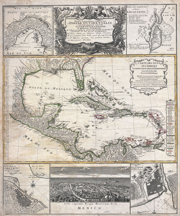
1737 Homann Heirs / D'Anville Map of Florida and the West Indies
IndiaeOccidentalis-homann-1734$750.00

Title
Mappa geographica, complectens I. Indiae Occidentalis partem mediam circum Panamensem II. Ipsumq. isthmum III. Ichnographiam praecipuorum locorum & portuum ad has terras pertinentium. / Carte des Isles de L'Amerique et Deplusieurs Pays de Terre Ferme situes su devant de ces Isles & autour de Golfe de Mexique.
1731 (dated, but probably a later printing) 23 x 19.5 in (58.42 x 49.53 cm)
1731 (dated, but probably a later printing) 23 x 19.5 in (58.42 x 49.53 cm)
Description
A wonderful example of J. B. Homann's spectacular map of the West Indies. Consists of maps based upon the admirable work of D'Anville complied into a single sheet. The primary map, attributed to D'Anville's work of 1731, depicts the West Indies from Mexico to the Lesser Antilles including the totality of Florida, parts of Carolina, and parts of northern South America. Southern Florida, in an attempted rendering of the Everglades, is shown as a series of lakes and islands connected by narrow canals. New Orleans and the mouths of the Mississippi are shown with relative accuracy as are Mexico and the West India Islands. Territories are color coded according the colonial powers that ruled them. The smaller maps include, from the top left, the Bay and Isthmus of Panama. In the upper right quadrant there is an excellent depiction of the port and harbor of St. Augustine, Florida. This is one of the earliest obtainable depictions of a harbor in Florida. The lower left quadrant features an inset plan of the city and harbor of Veracruz, Mexico. The lower right quadrant offers a similar plan of the city and harbor of San-Domingo. The bottom center features a splendid view of Mexico City, Mexico. The top center is adorned by a marvelous floral title cartouche depicting two Amerindians wearing elaborate feather headdresses and holding serrated spears. One of Homann's more interesting maps of the Americas.
CartographerS
Johann Baptist Homann (March 20, 1664 - July 1, 1724) was the most prominent and prolific map publisher of the 18th century. Homann was born in Oberkammlach, a small town near Kammlach, Bavaria, Germany. As a young man, Homann studied in a Jesuit school and nursed ambitions of becoming a Dominican priest. Nonetheless, he converted to Protestantism in 1687, when he was 23. It is not clear where he mastered engraving, but we believe it may have been in Amsterdam. Homann's earliest work we have identified is about 1689, and already exhibits a high degree of mastery. Around 1691, Homann moved to Nuremberg and registered as a notary. By this time, he was already making maps, and very good ones at that. He produced a map of the environs of Nürnberg in 1691/92, which suggests he was already a master engraver. Around 1693, Homann briefly relocated to Vienna, where he lived and studied printing and copper plate engraving until 1695. Until 1702, he worked in Nuremberg in the map trade under Jacob von Sandrart (1630 - 1708) and then David Funck (1642 - 1709). Afterward, he returned to Nuremberg, where, in 1702, he founded the commercial publishing firm that would bear his name. In the next five years, Homann produced hundreds of maps and developed a distinctive style characterized by heavy, detailed engraving, elaborate allegorical cartouche work, and vivid hand color. Due to the lower cost of printing in Germany, the Homann firm could undercut the dominant French and Dutch publishing houses while matching their diversity and quality. Despite copious output, Homann did not release his first major atlas until the 33-map Neuer Atlas of 1707, followed by a 60-map edition of 1710. By 1715, Homann's rising star caught the attention of the Holy Roman Emperor Charles VI, who appointed him Imperial Cartographer. In the same year, he was also appointed a member of the Royal Academy of Sciences in Berlin. Homann's prestigious title came with several significant advantages, including access to the most up-to-date cartographic information as well as the 'Privilege'. The Privilege was a type of early copyright offered to very few by the Holy Roman Emperor. Though less sophisticated than modern copyright legislation, the Privilege offered limited protection for several years. Most all J. B. Homann maps printed between 1715 and 1730 bear the inscription 'Cum Priviligio' or some variation. Following Homann's death in 1724, the firm's map plates and management passed to his son, Johann Christoph Homann (1703 - 1730). J. C. Homann, perhaps realizing that he would not long survive his father, stipulated in his will that the company would be inherited by his two head managers, Johann Georg Ebersberger (1695 - 1760) and Johann Michael Franz (1700 - 1761), and that it would publish only under the name 'Homann Heirs'. This designation, in various forms (Homannsche Heirs, Heritiers de Homann, Lat Homannianos Herod, Homannschen Erben, etc.) appears on maps from about 1731 onwards. The firm continued to publish maps in ever-diminishing quantities until the death of its last owner, Christoph Franz Fembo (1781 - 1848). More by this mapmaker...
Jean Baptiste Bourguignon d'Anville (1697 - 1782) was perhaps the most important and prolific cartographer of the 18th century. D'Anville's passion for cartography manifested during his school years when he amused himself by composing maps for Latin texts. There is a preserved manuscript dating to 1712, Graecia Vetus, which may be his earliest surviving map - he was only 15 when he drew it. He would retain an interest in the cartography of antiquity throughout his long career and published numerous atlases to focusing on the ancient world. At twenty-two D'Anville, sponsored by the Duke of Orleans, was appointed Geographer to the King of France. As both a cartographer and a geographer, he instituted a reform in the general practice of cartography. Unlike most period cartographers, D'Anville did not rely exclusively on earlier maps to inform his work, rather he based his maps on intense study and research. His maps were thus the most accurate and comprehensive of his period - truly the first modern maps. Thomas Basset and Philip Porter write: "It was because of D'Anville's resolve to depict only those features which could be proven to be true that his maps are often said to represent a scientific reformation in cartography." (The Journal of African History, Vol. 32, No. 3 (1991), pp. 367-413). In 1754, when D'Anville turned 57 and had reached the height of his career, he was elected to the Academie des Inscriptions. Later, at 76, following the death of Philippe Buache, D'Anville was appointed to both of the coveted positions Buache held: Premier Geographe du Roi, and Adjoint-Geographer of the Academie des Sciences. During his long career D'Anville published some 211 maps as well as 78 treatises on geography. D'Anville's vast reference library, consisting of over 9000 volumes, was acquired by the French government in 1779 and became the basis of the Depot Geographique - though D'Anville retained physical possession his death in 1782. Remarkably almost all of D'Anville's maps were produced by his own hand. His published maps, most of which were engraved by Guillaume de la Haye, are known to be near exact reproductions of D'Anville' manuscripts. The borders as well as the decorative cartouche work present on many of his maps were produced by his brother Hubert-Francois Bourguignon Gravelot. The work of D'Anville thus marked a transitional point in the history of cartography and opened the way to the maps of English cartographers Cary, Thomson and Pinkerton in the early 19th century. Learn More...
Condition
Very good condition. Minor water stain on left side, center. Original centerfold. Else clean.
References
Kapp, Kit S., 'The Early Maps of Panama up to 1865', Map Collectors Circle, Issue 73, no. 58. Lowery, Woodbury, The Lowery Collection: A Descriptive List of Maps of the Spanish Possessions within the Present Limits of the United States, 1502-1820, 360.