This item has been sold, but you can get on the Waitlist to be notified if another example becomes available, or purchase a digital scan.
1884 Imray Blueback Nautical Map of the Indian Ocean w/ extensive voyages noted
IndianOcean-imray-1884$375.00


Title
Indian Ocean.
1884 (dated) 31.5 x 53.25 in (80.01 x 135.255 cm) 1 : 788530
1884 (dated) 31.5 x 53.25 in (80.01 x 135.255 cm) 1 : 788530
Description
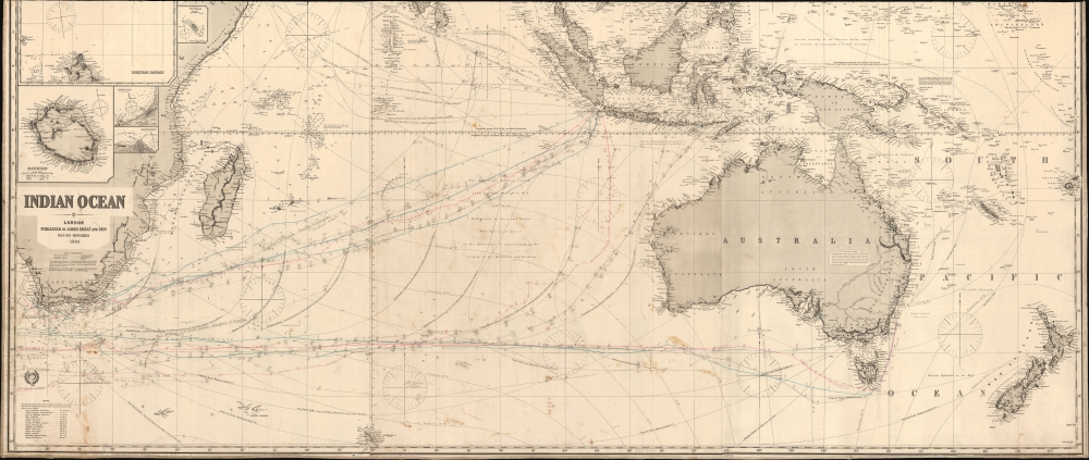
This is an 1884 James Imray blueback nautical map illustrating the Indian Ocean, as well as Cape Horn, the East Indies, Australia, and New Zealand. This was the essential chart of navigation to China and the East Indies in the late 19th century. The piece is most fascinating for its detailed manuscript records of multiple voyages, from New York, Cardiff, and Liverpool to Hong Kong, Manila, Sydney, and Bombay.
Voyages Recorded
We see manuscript tracks of at least 17 voyages around the Cape of Good Hope to points east ranging from Hong Kong to Sydney. A few are labeled, for example: the 1884 voyage of the McNear for Sydney under Captain J. N. Frost; and the McNear from Bombay to Liverpool; the 1893 voyage of the Celeste-Bumill (sp?) from Rio to Manila. Another series of voyages, to Hong Kong, seem related to the fortunes of the prominent Tucker Family of Wiscasset, Maine (their archives are preserved at the Bowdoin College Library). Most of the other voyages are harder to isolate or are unlabeled. The annotator has also noted strong gales, storms, and even a hurricane southwest of Australia.Blueback Charts
Blueback nautical charts began appearing in London in the late 18th century. Bluebacks, as they came to be called, were privately published large format nautical charts known for their distinctive blue paper backing. The backing, a commonly available blue manila paper traditionally used by publishers to wrap unbound pamphlets, was adopted as a practical way to reinforce the low-quality paper used by private chart publishers in an effort to cut costs. That being said, not all blueback charts are literally backed with blue paper, some are unbacked or backed with linen. Moreover, as blueback charts which were typically composed of multiple sheets, they were designed in a modular fashion, so that multiple charts could be joined to created truly massive custom maps suited for specific voyages. The earliest known blueback charts include a 1760 chart issued by Mount and Page, and a 1787 chart issued by Robert Sayer. The tradition took off in the early 19th century, when British publishers like John Hamilton Moore, Robert Blachford, James Imray, William Heather, John William Norie, Charles Wilson, David Steel, R. H. Laurie, and John Hobbs, among others, rose to dominate the chart trade. Bluebacks became so popular that the convention was embraced by chartmakers outside of England, including Americans Edmund March Blunt and George Eldridge, as well as Scandinavian, French, German, Russian, and Spanish chartmakers. Blueback charts remained popular until the late 19th century, when government subsidized organizations like the British Admiralty Hydrographic Office and the United States Coast Survey, began issuing their own superior charts on high quality paper that did not require reinforcement.Publication History and Census
This map was compiled and printed by James Imray and Sons in London in 1884. We see a few examples in institutional collections. The map occasionally appears on the market priced between 3000 - 9000 USD. However, we have priced this example accordingly given the loss along the top margin. However, we believe that the extensive manuscript annotation makes it more interesting than most other examples in superficially better condition.Cartographer
James Imray (May 16, 1803 - November 15, 1870) was a Scottish hydrographer and stationer active in London during the middle to latter part of the 19th century. Imray is best known as a the largest and most prominent producer of blue-back charts, a kind of nautical chart popular from about 1750 to 1920 and named for its distinctive blue paper backing (although not all charts that may be called "blue-backs" actually have a blue backing). Unlike government charts issued by the British Admiralty, U.S. Coast Survey, and other similar organizations, Imray's charts were a private profit based venture and not generally the result of unique survey work. Rather, Imray's charts were judicious and beautiful composites based upon pre-existing charts (some dating to the 17th century) and new information gleaned from governmental as well as commercial pilots and navigators. Imray was born in Spitalfields, England, the eldest son of a Jacobite dyer also named James. Imray did not follow his father profession, instead apprenticing to William Lukyn, a stationer. He established himself as a bookseller and bookbinder at 116 Minories Street, where he shared offices with the nautical chart publisher Robert Blanchford. In 1836 Imray signed on as a full partner in Blanchford's enterprise, christening themselves Blanchford & Imray. At this time the Blanchford firm lagged far behind competing chart publishers Norie and Laruie, nevertheless, with the injection of Imray's marketing savvy the firm began a long rise. James Imray bought out Blanchford's share in 1846, becoming the sole proprietor of the chart house, publishing under the imprint of James Imray. Relocating in 1850 to larger offices at 102 Minories, Imray was well on track to become the most prominent chart publisher in London. In 1854, when Imray's 25 year old son, James Frederick Imray, joined as a full partner, the firm again changed its imprint, this time to James Imray and Son. The elder Imray was a master of marketing and was quick to respond to trade shifts and historic events. Many of his most successful charts were targeted to specific trade routes, for example, he issued charts entitled "Cotton Ports of Georgia" and "Rice Ports of India". Other charts emerged quickly following such events as the 1849 California Gold Rush. Imray's rise also coincided with the development of governmental mapping organizations such as the Admiralty and the U.S. Coast Survey, whose work he appropriated and rebranded in practical format familiar to navigators. Imray's death in 1870 marked a major transition in the firm's output and began its decline. Though Imray's son, James Frederick, excelled at authoring pilot books he had little experience with charts and issued few new publications. Most James Frederick Imray publications issued from 1870 to 1899 were either revisions of earlier maps prepared by his father or copies of British Admiralty charts. Charts from this period are recognizable as being less decorative than the elder Imray's charts following the stylistic conventions established by the Admiralty. The Admiralty itself at the same time began to rise in prominence, issuing its own official charts that were both cheaper and more up to date than those offered by private enterprises. By the end of the century the firm was well in decline and, in 1899 "James Imray and Son" amalgamated with the similarly suffering "Norie and Wilson", which was itself acquired by Laurie in 1904. Today it continues to publish maritime charts as "Imray, Laurie, Norie and Wilson". More by this mapmaker...
Condition
Average. Missing about 4 inches from top of sheet. Soiling. Extensive annotations regarding countless voyages throughout.
References
New Bedford Whaling Museum, 00.222.327.